
-
 2476 Hits
-
 72.08% Score
-
 2 Votes
|
|
Route |
|---|---|
|
|
46.56187°N / 13.15119°E |
|
|
Hiking |
|
|
Summer, Fall |
|
|
Half a day |
|
|
Medium hard hike up |
|
|
Overview
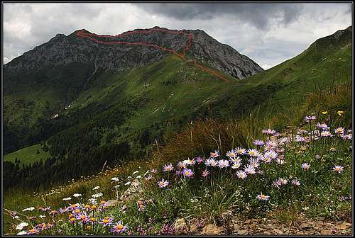
The normal (lower) and the route by the E ridge
The majority of visitors, coming from the south-east, from Forca di Lanza, 1831 m, will ascend Monte Zermula by the broad path, crossing the southern slopes of the mountain. It's comfortable, quick and well beaten, because in the World War I it was the main supply path for Italian positions on the mountain. Those who come on top over the N face, will descend there too. But if your ambition is only to hike up from the east, why not choosing the second path in order not to repeat the same path on the ascent and descent?
Just below the east ridge of Monte Zermula, so approximately 100 to 200 meters higher than the broad usual path, there is a narrow, but also marked path, called also 'Sentiero delle Trincee' ('The Path of Trenches'). The majority of positions during the World War I was just on the main ridge or a few meters below it. There are caves, dug through the crest rocks, gun nests, trenches and all that needed a path to supply those positions. Altogether the higher path is no longer than the usual approach, you will need for ascent perhaps 5 or ten minutes more. It goes more directly, but does also a few small descents, following the ridge line. It is much more narrow, requiring on a few places some care, but altogether not problematic at all. The panorama is the same or better - you are higher and you can occasionally go on the main ridge to have a look over the north walls. And from this path you can examine more remains from the World War I than from the normal ascent route. It does not matter which of the two paths you choose for the ascent and which one for the descent.
Getting There
As for the normal east ascent you start the tour on Passo del Cason di Lanza, 1552 m. Till above Forca di Lanza (saddle), 1831 m, both routes go by the same path, till there it's less than 1 hour. If you come from Paularo, you can also reach Forca di Lanza in 1 hour from the parking place at Casera Pizzul, 1532 m (southern approach).
Route Description
Above Forca di Lanza
From Passo del Cason di Lanza go south by the trail No. 442a. In good 15 minutes through the woods you will reach the nice grassy basin being situated among Zuc della Guardia (east), Monte Pizzul (south) and Monte Zermula (west). Proceed by the right, western slopes and ascend comfortably to Forca di Lanza. Good 45 minutes till here.
On Forca di Lanza you turn right. The path 442 ascends over the first grassy step slopes, above which the paths are branching. If not careful, you will see only the left, broader path, which soon starts crossing the slopes. That's the normal ascent route.
For the East ridge route you continue by the right path, which continues up by a nice grassy ridge. It gets more and more steep, the path starts ascending in turns over grassy and rocky slopes and so you gain the altitude to almost reach the east ridge of Monte Zermula. The path does not go just on the ridge, but starts crossing the slopes below it. Soon you see the first fortifications from the World War I. After that, the picture doesn't change much. The path goes by comfortable ledges and on some places by more narrow passages, all the time towards the left below the ridge. You can explore a few caves to have a look on the other side of the mountain, or you can ascend the main ridge. After passing the elevation 2129 m, the path descends a bit, then it hits the ridge again. There are a few passages where some care is needed. When almost hitting the ridge, you see the inscription "ferrata" on the rock. If you follow the cable some 2 meters, you will see where the N face ferrata comes up on the ridge. Now you are already very close to the summit. You may go by the ridge or continue just below it, then you hit the normal ascent path and in a few turns you are on top.
In average people will need 2 h 10 min from the parking place on the summit of Monte Zermula. By the Swiss Hiking Scale the tour would be graded T3 (in comparison with the normal route which is a solid T2).
Essential Gear
Only hiking gear: good shoes and poles.