
|
|
Route |
|---|---|
|
|
38.58633°N / 106.3205°W |
|
|
Download GPX » View Route on Map |
|
|
Summer |
|
|
Overview
Colorado’s Mount Aetna dominates views on the east side and to the north of Monarch Pass. The peak’s prominent feature is the south-facing “Grand Couloir.” A ridge connects Aetna to Taylor Mountain on the east.
If you are looking for a climb un-cluttered by a matrix of cairns and braided trails, scrambling up Aetna by the southeast ridge is your mountain.
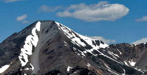
Mount Aetna from Monarch Pass Summit
Mount Aetna ranks number 127 in elevation among peaks in Colorado; number 74 among thirteeners.
Other guidebooks (e.g. Garratt & Martin; Borneman) recommend ascending by the ridge between Aetna and Taylor. When I climbed Aetna at the end of June 2017, that route was still deep in snow, and I didn’t bring my axe.
A SummitPost article describes a similar climb as the “South Ridge,” but with an initial approach from the Grand Couloir.
Getting There
Take US 50 west from Poncha Springs to the town of Garfield. There is a trailhead and parking about 100 feet west of the snowmobile tour shop. If you don’t have a high-clearance 4WD vehicle, park there. If you do have 4WD, drive approximately on FS 230 approximately 1.2 miles to the junction of FS 230C. It is not a difficult 4WD road. There is limited parking near the junction with FS 230C, close to the marked trail to Boss Lake.
The starting hiking elevation from US 50 is 9,680 feet; from FS 230, it is 10,430 feet.
Don’t bother trying to drive up FS 230C, even though it looks passable at the junction. The road is blocked by a large downed tree at 10,700 feet. There is no room turn around, so you will have to back down. Moss and grass growing on the roadbed suggests nobody has tried to drive it for years.
If you still use USGS 7.5’ quad maps, see Garfield. The Latitude 40° map Salida Buena Vista Colorado Trails, 2012 edition, and the National Geographic Salida, St. Elmo, Mount Shavano, 2008 edition appear to be accurate. The Latitude 40° version shows more of the roads off FS 230, but you may need a magnifier!Route
Starting from the junction with FS 230, hike up FS 230C. The road is easy to follow, passing the ruins of two cabins at about 11,200. The road deteriorates quickly above the cabins, and there are a number of side branches to the east. Stay left, bypassing Hoffman Park, and continue on a faint road to the mine at 12,000 feet. Scramble on dirt for about 400 feet vertical above the mine to rock on the ridge. From there, simply follow the ridge to the summit. The rock is broken all the way, but relatively solid. Test hand and foot holds if they seem questionable. There are definitely some Class 3 sections, particularly when approaching the summit. On the map, the route looks like this.
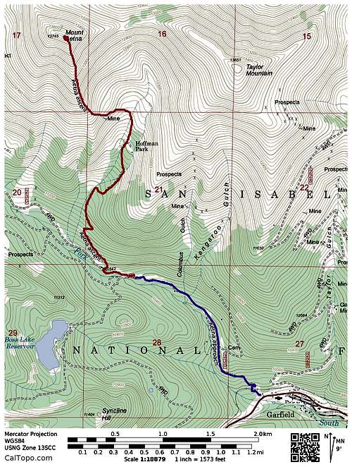
Route Map
On the ground, the route looks like this.
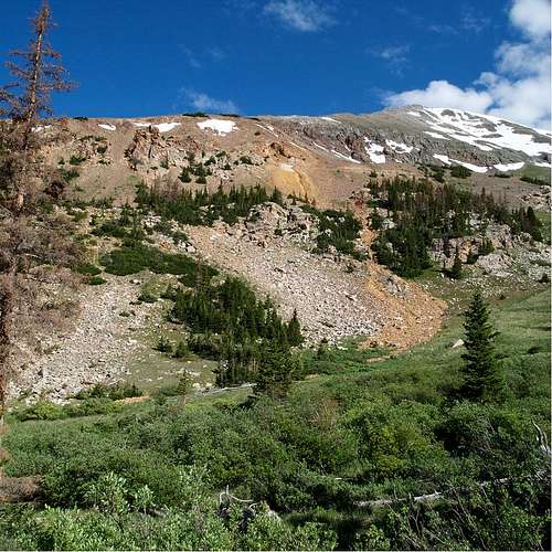
Summit Ridge Above the Mine
After starting the ridge, I saw few traces of human activity. There were three unmarked vertical stakes, perhaps leftovers from mining days. The one curious piece of litter I found was a beer can, with two bullet holes, at about 12,700 feet. The can was 12-ounce, early pull-tab top, dated to 1963. Someone had to have humped the can and a loaded gun up there. Given the age of the can, consumption of dubious beer can be excused.
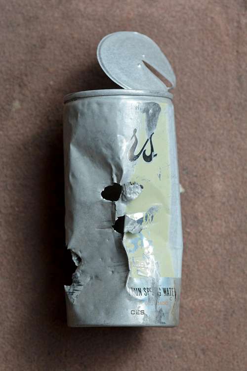
Shot-up Coors Can at 12,700 Feet
The one-way distance from the junction of FS 230 and 230C is 2.4 miles, gaining 3300 vertical feet. Starting from Monarch adds about 1.2 miles and 800 vertical feet, for a total of 3.7 miles and 4100 vertical feet.
One variant — only mentioned to caution against it — is a vague ridge dropping east off the summit to treeline at 12,000. I used it as my descent. It is steeper than the southeast ridge ascent, with loose rock all the way.