Japanese Route, August 2, 2009
Mount Alberta was one of many ideas on a long list of objectives I knew I might get on some day. Most folks know I am not into goal setting versus just getting out and climbing whatever I am thinking about at the time. On a last minute whim,
Jason Wilcox and I decided to give Mount Alberta a go. Only beta I had read about Mount Alberta, outside of the short description in the “book of lies”, was Bruce’s trip report on Summitpost and Everett’s article in the Canadian Alpine Journal. To read both of these accounts in one sitting,
I wondered if my nonchalant attitude towards Mount Alberta was in error. Long thought of as an oversized scramble by me, I was amazed at the time and difficulty it seemed to pose to certain parties.
In retrospect I would have to say that as long as the weather is on your side, it is basically an oversized scramble!
We crossed the river no worries. This
crossing might be one of the most mellow I have ever made really, so it just depends on what you are use to. Left our wet runners on the other side and proceeded directly up the hill past one of the more outstanding waterfalls in all of the Canadian Rockies. The water hits a huge wall which diverts it directly down with tremendous force. Continue up a somewhat flooded trail (wet in July) up to a boulder field that is best traversed via the left side. Cross a fast flowing creek here and continue up several hills to below the col of
Mount Woolley and Diadem Peak.
Turn left and hike up
endless amounts of scree to the left shoulder of Mount Woolley. Mount Alberta along with the North and South Twins will come into full view. Descend a considerable distance skirting glacier ice to the hut below. Our plan was to bivy on Mount Alberta versus using the hut and this seems to be the general practice (except for Bruce who seemed to have camped one night on the approach to the hut, camped at the hut and bivyed even a third night on the mountain before starting their climb). However we got to the hut and a rain and hail storm started to form, so we ate an early dinner and decided to do the climb
hut to hut even though it would make for a long day.
One of the main reasons hut to hut is not a first choice for the climb is that you
lose well over a 1000’ (if not closer to 2000’) from the hut before you start to re-ascend again.
(my altimeter read 12,350’ accumulated gain for the entire trip!) The main advantage of hut to hut though is that you can cover this ground with light packs. We took off at 4:AM the next morning and had decent light by the time we hit the far eastern corner of the mountain.
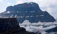
The ascent is for the most part fairly uneventful. We never quite saw the
“elephant asses” or located the standard bivy, but knew exactly where we needed to gain the ridge. The most fun of the entire day was taking an off route version prompted by a photo of Everett’s that took us up an ice choked gully (the traditional approach would go way right of this gully and serves as the best descent) and onto an
exposed “horseshoe shaped” ledge! Circumventing that ledge solo took a little courage, but was like a ride at Disney World, only free admission.
The scrambling after the ledge continued uneventful for quite a few kilometers of loose irritating side stepping scree, always staying below the snow bands as we moved northwest. Although never really noticing the “elephant asses”, one of these features actually has a very
aesthetic arch window cut out of it. The Japanese Route starts to the left of this arch. We saw a piton station (I think Everett and Doug might have put it there) out right and followed this gully instead. That meant a little tougher run out first pitch (I had three pieces of gear with me total outside of a few pitons). Everett called it 5.9, but it is not that hard. I had to build a piton station at 60m, but of course we took our gear out, so if you follow this version you will have to have a hammer and pitons. This whole line is much more direct than the original start of the Japanese route. The 2nd pitch goes real easy up to a small water fall. Then I traversed left (3rd pitch) through the water and caught up to the top of the third or fourth pitch of the Japanese route. From there it is easy to follow the route as it continues rightward and up to an obvious notch in the ridge. Of course we climbed in boots. The rock is a choss fest to say the least. Not dropping rock on your belayer is always of primary concern.
The crux, if there was one, was crossing the snow-ice gully up high on the 2nd to last face pitch before exiting onto the summit ridge. To avoid putting on our crampons
(which we never used), we placed an ice screw and used our alpine axes to scurry over to the other side at a slung block. The rock improved on the last two pitches a bit. I was the first onto the summit ridge and sat in a very cool notch as I brought the 2nd up and was amazed at how still it was at 11,000’! Once we were both on the ridge, we left a rope and soloed across the ridge to the one rappel mentioned in all the beta (although it could be easily down climbed). Left a rope there and continued to the summit.
We spent less than 1.5 hrs on the ridge getting to the summit and only 1 hour on return.
An umbrella is still there or has been replaced many times I assume. It was still functional as well. No summit register to speak of (we left a new one) and according to the hut register, we were the first party to summit Mount Alberta in 2009 (August 2).
We quickly descended as storm clouds started rolling in.
We simul rapped whilst coiling the ropes out which would be the most efficient method of dealing with the low angled face. We made it back to the hut in 20 hours from when we left. On return the sky was lit up with lightning. It rained as soon as we shut the hut door.
The next morning took no time to get out really and the river at
1:PM or so was no worry to cross.
Comments
No comments posted yet.