
-
 4178 Hits
-
 74.92% Score
-
 5 Votes
|
|
Route |
|---|---|
|
|
48.43635°N / 113.36899°W |
|
|
Hiking, Mountaineering |
|
|
A long day |
|
|
Class 3 |
|
|
Moderate |
|
|
Mount Ellsworth is in the far left side of the above photo. The triangle shaped red point is the unnamed point where the descent to the saddle below Ellsworth begins.
Behind Ellsworth is Grizzly Mountain. On the far right is Mount Rockwell. Some of the peaks in the Nyack region are seen in the center of the photo.
Layout designed for best viewing on a "1024 x 768" screen.
An enjoyable day with incredible views along the Continental Divide, into the Nyack area and Two Medicine Peaks
In his guidebook, Edwards writes of climbing Ellsworth from the Appistoki Basin below Mount Henry’s 2,000 foot face. That route description is provided in the Mount Ellsworth main page.
Please see the main page for Red tape, Weather, Gear Recommendations and other important factoids that are not provided here.
If I were to do this route again I would strongly consider accessing Ellsworth via Medicine Peak and Mount Henry rather than climbing up through the Appistoki Creek Drainage.
The goal is to get to Point 8650 where both routes converge.
Point 8650 can be approached from both Mount Henry and Appistoki Peak. Consider the Scenic Point Ridge Walk for the following reasons: 1) more scenic, 2) has less loose scree therefore is a potentially less tiring route, and 3) there is much less off tail elevation gain. Generally the only significant elevation gained is from the saddle below Medicine Peak to its summit. This is about 1,000 feet on pretty descent footing. From there on out it basically is a ridge walk with a brief and enjoyable climb along the arete prior to summiting Mount Henry.
The only draw back is a slight increase in mileage and perhaps a slightly longer trip time but the round trip distance from trailhead to summit to trailhead still could be less than 10 hours for those who are used to climbing in Glacier National Park.
Route Overview:
 Medicine and Henry from near the Scenic Point Trail
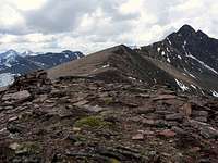 Medicine Peak to Mount Henry, vantana photo
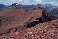 Point 8650 from Henry
 Ellsworth from near Point 8650
 Summit Cliffs from saddle
 Summit Ridge
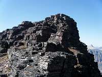 Summit Cliffs
This climb is featured in Edwards’ “Routes Among The Peaks” on pages 315-316 in A Climber’s Guide to Glacier National Park. Edwards states in his guidebook that the trip should take about 10 hours. It also crosses unnamed peaks and allows access for other peaks in the area such as accessing Mt. Ellsworth on an extended spur route. Mount Henry sits at the head of Appistoki Creek and has an imposing face that rises over 1,700 feet above the valley floor. Total elevation gained from the trailhead is 3,867 to the summit of Mt. Henry.
Special Considerations: The rock in Glacier Park is widely varied and it is not unusual to find several different types of rock on any given route. Know your rocks and be certain of your safety. J. Gordon Edwards has an excellent section in his guidebook on rock and climbing safety. Be safe and know your limitations as well as those who are climbing with you. Also refer to the following links for further details: GNP Rock and Grading System and the GMS Climbing Guidelines.
Route Description:
Follow the Scenic Point trail to its highest point at approximately 7,400 feet in elevation; from this point walk along the east side of the point labeled on the topo maps as 7643. Walk to the saddle below Medicine Peak and climb through the solid scree slopes to the dark red colored rocks (argillite) below Medicine Peak. Side hilling to the climber’s right is an effective way to gain elevation. Keep gaining that elevation and soon the summit cairn of Medicine will be seen of cliffs along the wall will force vertical scrambling. There is a U.S. Geological Survey marker located (on the Appistoki Valley side) about 3 feet from the cairn.From Medicine Peak continue southwest along the ridge. Climbers can easily bypass the first few minor elevation annoyances along the ridge if desired. Within a short time climbers will be presented with the final false summit which is most easily avoided all together by walking around its south side. Stay near the ridge and the platform to begin the Arete Route will be located. For those who prefer not to climb over the arete the scree gully awaits you! It is from this same platform that the gully route begins. See the
The Arete Route involves some easy Class 4 climbing across the generally level arete. The route has solid hand and foot holds throughout the brief 40 foot wide crossing of the arete. After crossing the arete a Class 3 scramble through a “scree free” gully leads to the final shelf below the true summit. This is also the location where the gully scree route is rejoined.
There are a number of options to reach the actual summit from the shelf. None of them have to be more difficult than class 3. At the summit enjoy views into the Nyack area and up to Flinsch and Rising Wolf.
A PVC register is located in the summit cairn.
From Henry continue traversing to the north through the argylite domes to Point 8650. From 8650 continue along the ridge to the northwest to the next point and then drop down into the basin below Ellsworth. The cliffs on the north side of Ellsworth are impressive. The scree field to the east of Ellsworth is less than impressive and looked loose and unstable. The scree field would be loads of fun to descend but not a lot of fun to climb so stay on the right (North) side of the scree field while climbing to the ridge below Ellsworth. The intermitted sets of cliffs and easy class 3 scrambling provide a brief interlude to strolling along the open ridges. This portion of the climb is brief.
The view along the Continental Divide is amazing as are the spires on the north side of Buttercup Park.
Then walk up the ridge to the final summit cliffs which present enjoyable class 3 scrambling that is certainly too short in length for most climber’s liking. There is a summit cairn. I did not look for a register the views were just too good!
Return Options:
1) Continue to Never Laughs Mountain2) Retrace route
3) Retrace route to Point 8650 and then descend to summit Appistoki Peak and use Appistoki Creek to reach the Scenic Point Trail
4) Continue along the Continental Divide to Firebrand Pass and then to Lubec Lake Trailhead. This would be a long day but is not significantly challenging.
When to Climb:
 One of the spectacular views from Ellsworth
It is possible to complete this route during most months of the year. When the route is snow free obviously depends upon how much snowfall the area gets.
Spring as well as early summer snow fall (even as late as the middle of June) also is unpredictable and it would be best to have alternative routes and areas as a back-up. It would be necessary to ski/snowshoe to this route after the roads close. Roads in the Two Medicine area typically open by the first week of June.
Go to Plan Your Visit road conditions, road repairs and delay schedules as well as estimated opening information.
Obviously it will take more work to get to these peaks in the winter. Also know that it will take rescuers just as long so be prepared.
The arete route on Mount Henry will be snow free before the gully route so if you climb early in the season expect to climb along the arete.
External Links:
Two Medicine Trail MapGlacier Map