
-
 20697 Hits
-
 89.39% Score
-
 29 Votes
|
|
Mountain/Rock |
|---|---|
|
|
51.41686°N / 116.27347°W |
|
|
9763 ft / 2976 m |
|
|
Overview
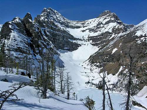
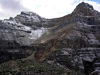
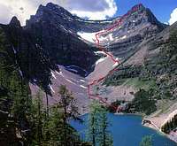
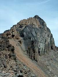
Mount Niblock is one of two peaks that dominates the view west of Lake Agnes. The other being Mount Whyte Mount Niblock is named after a CP rail offical who visted the area in 1886. This route sees a lot of traffic each year. It's a great way to spend a day in the mountains with a pleasant approach and then some good sweating up the ridge to the summit. This route and many others are well described in the guidebook Scrambles in the Canadian Rockies by Alan Kane. Pages 229-230. Elevation gain from the trailhead 1,260 metres
Getting There
You will have to get yourself to Lake Louise. From Calgary take the Trans Canada (1) west through Canmore, Banff, then Drive to Lake Louise along the #1. After driving by the Samson Mall area continue along the road up towards the Chateau. Park in the large parkinglot with the hundreds of people. Note you should get there early: while the parking lot is big it can fill up. Secondly you will avoid some of the crowd that forms in the first part of the route. The trail head is found along the lake to the right. When you reach the fork in the trail take the left which is signed to Lake Agnes. From here follow the obvious trail that winds its way gently to Lake Agnes then continues up, to the right winding its way through the scree to the summit. Depending on the weather there can be a couple of slippery sections (for which you should use caution) but nothing in the way of great difficulty. This is an excellent day of hiking/scrambling.
Red Tape
You will need a Parks pass. This can be picked up as you enter the Park on the highway near Banff. Rates for Parks Canada as of July 1, 2006: Wilderness Backcountry: $9/night Wilderness Pass: $63/year Reservation Fee: $12/group Park Entry: $16/group/day $109/year Call the Banff Information Center for current news (403) 762-4256. This is a day trip.
When To Climb
Safest July to September. Can be done earlier with crampons and ice axe. Some of the snow patches remain in and just below the col till late in the summer and should be avoided by those without experience or proper footwear. If the weather is good you should be able to follow the route without problems. Check with the Rangers.
Camping
There is no camping allowed in this area. But there are many campsites in the Lake Louise area. One place that is recommended is the ACC/Hostel in Lake Louise. This place has a small cosy restaurant with good food as well as kitchen facilities and lots of room for approx 36$ Canadian a night. While this is twice as much as the ACC lodge in Canmore it is still a bargain when compared to the cost of hotels in the area. No camping is allowed on the mountain or in the Lake Agnes area. For Lake Louise Area camping spots call (403) 762-3600.
Mountain Conditions
Check with the Rangers in Lake Louise. You can sign in and out (probably wise to do so.. but remember to sign out!) Beware of the the weather conditions and dress accordingly. If the weather turns trails can ice up and people can get into trouble because they went up in nice weather then the route iced up in the snow or rain and made the route dicey for the descent. Excellent scramble. www.weatheroffice.com or (403) 762-2088 for weather conditions. Banff Warden Office (403) 762-4506 for route info. Lake Louise Warden Office (403) 522-3866