Overview
I thought this might be a good mountain to add for a couple of reasons: it was the first mountain Sir Edmund Hillary climbed, and when I wanted to do some research on the Mueller hut tramp, I couldn't find much info.
So about the mountain, it is on the sealy range, relatively low in altitude 1933m and is not so much a climb as a fairly easy rock scramble to the summit. It is situated above Mueller Hut and has great panaramic views of the area.
It is more a tramp than a mountain climb, so If you are after a night in the mountains without wanting to drag all that mountaineering gear around, this is a good one to do :) Though there are apparrantly some good practice climbing spots from the Annette Plateau - I didn't get out there in Feb 05, but am planning on having a look and climb there in Feb 06, so I'll report back on Annette plateau then :)
Getting There
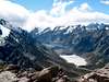
Begin fom Mt cook village. Take the track to the Sealy tarns which you can begin from either the White Horse Hill camping area or the the Hermatige Hotel. The track ventures out to Kea point which overlooks Mueller glacier and has some great views with Mt Sefton looming overhead. It is about a 15min side trip to get here to Kea point, but easy walking and worth the views. From there, the track heads up to the sealy tarns and is a bit of a knee-bender at times on the way up (and a great quads work out on the way back down!). This is a nice spot to have some morning tea and take a few pictures of the village below, Mt Cook up the Hooker valley, Mt Sefton, or just anything you want to snap your camera at really. From the tarns there is pretty much no track, but orange and black poles mark the route (when you can see them, we came down in thick cloud and snow, yes in feb!!, and couldn't see the poles anyway)
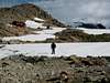
The route then swings north and is a rock scramble up to the ridge, where you come face to face with Mt Sefton (3151m) overlooking the Mueller Glacier. As you near the top of the ridge, the last part is a scramble up rocky scree or snow if it hasn't melted - this bit is fairly steep so an ice axe may be useful here if there is snow. From the top of the ridge, rock cairns mark the route south for about a 15-20 min walk to Mueller Hut. The Hut itself has an interesting history on how it was built and wiped out a couple of times by avelanches...there is info at the hut on all this (don't worry about avelanches now though, it is in a fairly safe position).
You can't miss Mt Ollivier, it is right behind the hut. It is a fairly easy scramble up to the summit, about 40mins - 1 hr. In good weather, the views are great!! from the hut you can see the peaks of the main divide dominated by Mt Cook. You can also hear plenty of avelanche action going on in the Mt Sefton direction which is pretty cool.
Red Tape
As with most of NZ there is very little to no red tape. You don't need to book in advance for this one like the great walks. The hut is $20 per night and just book in at the DOC up near the Hermatige hotel. Camping is allowed up there also (plenty of nice flat snow feilds to pitch the tent on) and doesn't cost anything I think (though if I'm wrong please correct me). Oh, and there are plenty of those inquisitive Kea up there, so don't leave anything lying around outside or they will destroy it!! Kea are basically mountain parrots, kind of stocky looking with short wings, but they are pretty cool :)
When To Climb
Pretty much all year round I think, though winter would be more difficult. There is snow there most of the year - we were there in Feb and there was still plenty of it . The route up past the Sealy tarns may be a bit hairy in winter if you put a foot wrong and go through the ice - there would be plenty of small cravasses to sprain an ankle or break a leg in as there is a bit of rock hoping to do up to the ridge. If this is covered over with snow/ice in winter, then there may be some thin parts you would go right through. An ice axe would be advisable in winter too!!!
Camping
The Hut is $20 (as discussed above) but you can also camp there - lots of flat snow feilds to pitch the tent on. I don't think the camping costs you anything, though I could be mistaken. There is also a Hut Warden at the hut during the summer months.


Rick B - Jan 21, 2006 10:57 pm - Voted 10/10
Untitled CommentGoogle Earth, combined with my DOC map, says that Mt. Ollivier is located at (170.06261, -43.72527).
http://www.summitpost.org/mountains/gmap.pl?lat=170.06475&lon=-43.72472&z=3
If you enter these coordinates on your page, it will show up on the interactive map.
gimpilator - Nov 29, 2015 1:18 pm - Hasn't voted
Re: Untitled CommentI second that. Please add the coordinates to this page.