
|
|
Route |
|---|---|
|
|
36.68870°N / 81.5327°W |
|
|
Download GPX » View Route on Map |
|
|
Hiking |
|
|
Spring, Summer, Fall, Winter |
|
|
Half a day |
|
|
Class 1 |
|
|
Overview
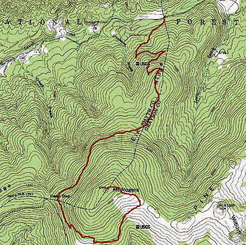
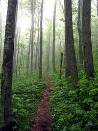
The Mount Rogers Trail is a very scenic, if not circuitous, route to the summit of Mount Rogers. While the straight line distance from trailhead to summit is only 2.2 miles, the actual trail mileage is a little over 6 miles. It's a beautiful hike through a dense Spruce-fir forest the whole way.
The Class 1 trail starts at VA-603, almost directly north of the summit and it circumnavigates the peak as it ascends the mountain, much like a spiral staircase. I do not recommend trail cutting. Apart from the environmental impact, the terrain is not very friendly for bushwhacking, with thick brush and a considerable number of fallen trees in some areas.
Experienced hikers will consider the route to be very easy. Less experienced hikers who come to climb the state highpoint should not have any difficulty either, provided that you are fit enough to hike the distance. The lower half of the trail is very gentle. The upper half gets a lot rockier and may be slippery if wet. The trail is well maintained and well marked though.
Trailhead Elevation: 3800 ft
Net Elevation Gain to summit: ~2500 ft
Distance: 12.5 miles round trip
Getting There
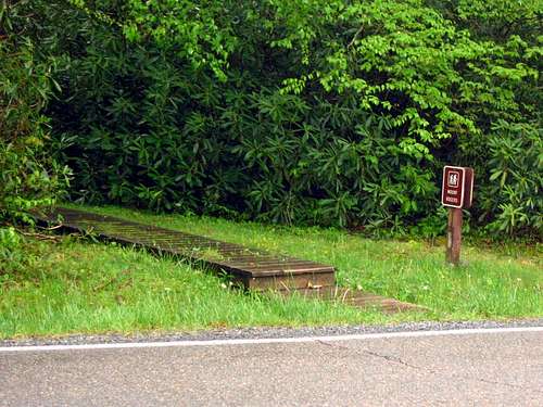
The trailhead is located on VA-603 between Konnarock and Troutdale, VA, almost due north of Mount Rogers. There is a small trailhead sign on the south side of the road. There is also a green sign right there that marks the boundary of Smyth and Grayson Counties. Parking for 7-8 cars is available on the north side of the road.
Route Description
The trail is very well marked the entire way and begins with 100ft of boardwalk, presumably to protect the grounds at the start. The trail heads in a southwesterly direction on a very moderate incline before cutting back to the east. The are 4 gentle switchbacks total.
At approx 2 miles you will reach the apex of Elk Ridge, where you'll cross the Lewis Fork spur trail. Continue straight on the Mount Rogers Trail in a southwesterly direction as it circles around the west side of the summit in a counter clockwise direction.
At approx 4 miles (at Deep Gap), the Mount Rogers Trail joins the Appalachian Trail (AT). Follow the AT south (to the left), then east, and then finally northeast until the AT splits off from the Mount Rogers Trail near the Thomas Knob shelter. Follow the Mount Rogers spur trail west towards the summit for another 1/2 mile.
Blazes and Trail Signs
Trees are marked with blue blazes along the Mount Rogers Trail until it joins the AT, at which point the blazes turn white. The blazes become blue again after the Mount Rogers spur trail splits from the AT and turns towards the summit. Be sure to follow the blue blazes at the trail split.
The trail intersections are also well marked with trail signs.

|
|

|

|
Camping Beta
Camping beta along the Mount Rogers Trail:
- Near Trailhead: Grindstone Campground, on VA-603, 0.25 mile west of the trailhead (fee camping)
- 2 miles: Lewis Fork campsite, intersection of the Mount Rogers Trail and the Lewis Fork spur trail (free)
- 3.5 miles: Campsite at 4900' elevation along the Mount Rogers Trail, before Deep Gap (free)
- 6 miles: Thomas Knob shelter, west of the summit along the Appalachian Trail, just off of the Mount Rogers Trail (free but give priority to AT hikers)