
|
|
Mountain/Rock |
|---|---|
|
|
66.29000°N / 65.25°W |
|
|
6076 ft / 1852 m |
|
|
Overview
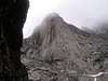
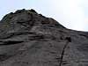
Mt. Tirokwa is one of the lesser known peaks in the park... though amongst rock climbers and big wall climbers alike it is well known. Tirokwa's western headwall is a 850m wall of smoothened granite that like Thor and Asgard has proven irresistable over the years to climbers. There are several routes to the top consisting of between 10 and 15 pitches of class VI climbing... some of the most challenging climbs in the country. Two of Tirokwa's other faces offer up 700 m walls so this peak offers a lot to those who love 'big wall' climbing.
Like Asgard and Thor it was first climbed in the 1950's by an Arctic Institute of North America party that pioneered many of the first routes in the park. Similar to many of the other big peaks in the park Tirokwa has regular rockfalls throughout the day so falling rock is a serious concern.
Tirokwa is located to south of Thor and Breidablik-Baldr... just where the Akshayuk Pass opens up in the long straight corridor of mythical peaks is where this peak can be found.
There exists mixed mountaineering and rock climbing routes to the top via Tirokwa's northern face... though at this time there is no route information for such routes. Tirokwa has been climbed by people simply seeking to reach the top, but they never documented their paths. This still remains a daunting task even for seasoned climbers, but for those simply seeking the summit there are other paths and other ways to experience this place.
If one is looking for a true wilderness experience this is also the place... because Tirokwa is located above the Arctic Circle it experiences 24 hours of daylight in the summer and 24 hours of darkness in the winter. It is possible to wander for days without encountering another soul or seeing any traces of humanity... there are few places like this left on earth... sadly.
Like all of the big peaks Tirokwa is located in 19700 square kilometer Auyuittuq National Park on baffin Island. A place very popular amongst climbers and trekkers during the brief but furious Arctic summer. For more info. on Auyuittuq check the pages of Mt. Thor or Mt. Asgard.
*** All photos used with permission from Neil Monteith and Colin Salias
 |  |  |  |  |
Getting There
This is most assuredly the most difficult part far and away, the costs involved can be somewhat prohibitive. Tour groups offer 15 day packages which can run in excess of $5000 CDN easily (especially in the winter)... but closer to $2500-3500 for most expeditions. The trick is to arrange a flight into Pangnirtung, quite often by way of Churchill Manitoba or Montreal.
To say that Auyuittuq is off the beaten path is more than a small understatement. It is incredibly remote. From Pangnirtung one must take a 30km boat ride (or if the fjord is frozen one must use a snowmobile) to the park entrance at the head of the Akshayuk Pass (which was once known as the Pangnirtung Pass). The route cuts across the Cumberland Peninsula and is the main travel route year round, though most especially in winter.
The park entrance is located here at the head of the valley and here is located the one and only Ranger Station in the entire park. The Weasel And Owl rivers flow through the valley, and one has to ford the river as well as several runoff streams as you make your way along the valley floor.
The trail is marked by ‘Inukshuks’ which are man shaped cairns that are placed at distant but regular intervals so one doesn’t lose their way… though that is kind of hard to do. As the route only follows the valley to its terminus.
Like Thor and Breidablick-Baldr, Tirokwa is located on the Akshayuk Pass it is simply on the Eastern side not the Western side and is about 15km from the park entrance and about 10km south of Baldr and 5km south of Thor. Tirokwa is located just where the pass opens up and straightens out to grant one access to peaks like Breidablik-Baldr, Thor and Asgard.
Tirokwa is perhpas the third most popular peak in the park for big wall climbing after Asgard and Thor (of course). Its 850 m headwall has drawn many climbers to try and conquer this mighty precipice. Tirokwa stands in the second tier with Freya for its popularity with big wall climbers.
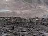
The lower slopes of Tirokwa are a maze of treacherous loose scree which makes for somewhat of a nightmarish approach to Tirokwa. It can take a full half day to negotiate this slope of loose rock just to gain access to the Tirokwa headwall.
There exists other less challenging routes to the top of Tirokwa that involve a mix of mountaineering and rock climbing skills for those wishing to simply get to the top of this peak. There is no real information out there however at this time for any routes other than the rock climbing ones so if I can find them I'll add them later on.
 |  |  |
Red Tape
Yes permits are required, they can be purchased for either $15 a day or an annual permit can be purchased for $100 at the Parks Visitor Information Center in Pangnirtung. For more info. you can call 1 867 473 8828 or try nunavut_info@pc.gc.ca. There are no real seasonal closures to speak of... though very few would want to visit the area in the dead of winter as temperatures hover for weeks on end around -40 degrees celsius or colder. Winter expeditions head up usually in late March or April when winter begins to loosen its icy grip just a little.
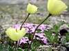
Its asked that you stick to walking across rock, sand or snow especially if wildflowers and other rare Arctic plants are out and that you leave the local animals alone. Please also be sure to pack in what you pack out... this is raw unspoiled wilderness at its finest... please respect that
When To Climb
The best time for climbing is the summer months between mid June to mid August though one can stretch the season earlier in June or later into the first week of September if the weather holds.
The greatest obstacle to overcome in any other season is winter itself and of course the usual logistical difficulties.. such as arranging transportation, local guides etc. this can all be compunded infinitely by the return of storms to the area. I haven't heard whether there have been early spring climbs or not though I believe it is possible though the costs and logistics would be more than a little prohibitive
 |
Camping
Camping is allowed. The only official site is near the entrance to the Akshayuk Valley near Overlord Mountain. The other sites are officially termed random sites which means camp where you find a good spot. Preferably not too close to the Weasel or Owl rivers and somewhere sheltered as the wind is known to really whip down through the valley. There is a small hut locted near the base of the mountain which can sleep 2-4 people. There are huts located near Mt. Thor and at the park entrance near Mt. Overlord.
Since the Peak is located right near Windy Lake you can use the hut located there as it might be safer than camping at the base of Tirokwa because of the prevalence of regular and very serious rockfalls.
Mountain Conditions
The only phone number to call for up to date conditions is the one already provided in the red tape section, and the web address provided should also yield relatively accurate weather conditions. The other web site you could try is the Parks Canada website which is www.pc.gc.ca/auyuittuq. The phone number provided is for the Park superintendent so it should be relatively easy to discover the weather conditions from there.
Failing all of this you could try www.theweathernetwork.com and type in Iqaluit it will give you up to the hour weather conditions.