
-
 16318 Hits
-
 73.12% Score
-
 4 Votes
|
|
Mountain/Rock |
|---|---|
|
|
38.26356°N / 122.22089°W |
|
|
Napa |
|
|
Hiking |
|
|
Spring, Summer, Fall, Winter |
|
|
1638 ft / 499 m |
|
|
Overview
Sugarloaf Mountain is the highest point in Skyline Wilderness Park, which sits just outside the southeast corner of the city of Napa. Though there are higher peaks within the Napa valley, few are quite so convenient as Sugarloaf. The climb also offers a significant elevation gain (1,526 feet when starting from an elevation of 112 feet at the trailhead).There are a host of activities going on at the base of the park, including archery, frisbee golf, a high ropes course, and more. Horseback riding is also permitted. Unfortunately, no dogs are allowed. There is an elaborate network of trails within the park, many of which are fit for mountain biking as well as hiking.
There is essentially one route up Sugarloaf Mountain, though it is possible to take a more circuitous approach and go up the "back side." To ascend via the primary route, park at the main lot for Skyline Wilderness Park. Begin via the Lake Marie Trail, which is essentially a jeep road that serves as the main artery for the entire park. The broad, gradual rise of Sugarloaf Mountain will loom straight ahead as you begin the hike. Most of the other trails, which are well maintained single tracks, branch off of the Lake Marie Trail. Approximately 1.5 miles in to the Lake Marie Trail, you will see an outhouse on your left, along with a sign for the Thatchers Rim Rock Trail. Signage is very clear and the trails are obvious. The Thatchers Rim Rock trail will proceed for another 1.8 miles to the summit of Sugarloaf Mountain. The trail then descends down the "back side" of the mountain and eventually reconnects with the Lake Marie Trail. Thus, it's possible to do the hike as a loop. If you choose the loop version, you will pass by the small but quaint Lake Marie.

The total round-trip distance is approximately 6.55 miles if you go with the standard out and back route. Total elevation gain for the trip is roughly 2,000 feet. It is possible to jog the bottom two thirds of this hike. However, a few steep grades and loose gravel make trail running, particularly downhill, a little difficult toward the top.
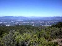
Just before the summit, you will be treated to some truly panoramic views of the Napa Valley. On a clear day, I would guess that you could eye the Golden Gate Bridge to the south and perhaps Mount Shasta far to the north, especially if you bring a pair of binoculars. The summit itself is ensconced in trees and brush; the best views come just a tenth of a mile beforehand.
Deer are commonly seen on the trail, as well as wild turkey and hawks. There is a warning sign at the trailhead to look out for wild boars, though I have never heard of anyone having an encounter with one. Do keep a look out for snakes.
Getting There
Skyline Wilderness Park is exceptionally easy to access. From the intersection of Imola Avenue and Soscol Avenue/Highway 121, proceed East on Imola Avenue. After a little over a mile, you will see the entrance to Skyline Wilderness Park on the right side of the road.If you're using an automobile navigation system, use the address of 2201 Imola Avenue, Napa, CA 94559 as your destination.
Parking is abundant.
There are apparently free access points in to Skyline Wilderness Park. However, I am not certain whether these are sanctioned or if they constitute freeloading.
Red Tape
There is a $5 fee to use the park. Hours of operation are 8:00 a.m. to 7:00 p.m.Camping
Overnight camping is prohibited.When to Climb
Sugarloaf Mountain can be climbed year round. The ideal times are in the spring and fall, when temperatures are more mild.If you opt to climb in the summer, get an early start and bring lots of water, as the heat can be oppressive and you pass through several stretches without any tree cover. On the average Napa summer day, if you get to the top before 9:30 you may be treated to a view from above the fog inversion.
In the winter, it's not inconceivable that the top may get the occasional dusting of snow. However, if you're looking for snow near the Napa area, the much higher Mount Saint Helena to the north of Sugarloaf is a better bet.
External Links
The website for Skyline Wilderness Park has a lot of useful information, including a full park map with every trail plotted.http://www.skylinepark.org