Intro.
Above the mountain village of Cercedilla, the seven peaks of Siete Picos domain the lanscape. And easy and beautiful trek will take us to the highest of all them, and will deserve one day of our lives.
The ´Siete Picos´ (Seven Peaks) massif is located in the Sierra de Guadarrama (Guadarrama Mountain Range) and easily accedable by car from Madrid (Spain´s capital) in an hour. The actual massif is formed by six peaks, from east to west:
- Seventh Peak, 2.138 m.
- Sixth Peak, 2.117 m.
- Fifth Peak, 2.107 m.
- Fourth Peak, 2.088 m.
- Third Peak, 2.094 m.
- Second Peak, 2.089 m.
And together with Majalasna Peak, 1.933 m., form the Siete Picos massif. Majalasna is a just a little SW from the Second Peak.
The Guadarrama Mountain Range is part of the Sistema Central (Central Mountain Range) that divides Spain in two.
The best way to approach Siete Picos is from ´Puerto de Navacerrada´ (Navacerrada Road Pass), 1.860 m, another optional way to approach Siete Picos would be from the mountain village of Cercedilla, 1.200 m.
By Car:
- Puerto de Navacerrada is about an hour drive NW from Madrid. You could either leave Madrid by the A6 freeway to the city of Villalba (exit 37) and once there take the M-601 highway for 20 km to Puerto de Navacerrada, or take from Madrid the M-607 highway to Colmenar Viejo, and continue to Cerceda and then to Navacerrada where we should join the M-601 highway to Puerto de Navacerrada. The best scenic way would be the second option.
- To get to Cercedilla take the A6 freeway from Madrid and right after passing the Villalba exit, you should take the N-VI Pto. de Guadarrama exit, follow the N-VI to Guadarrama and as soon as we pass the last red light take the road M-622 to the right that goes to Los Molinos and Cercedilla. Just up the road from Cercedillas´ railway station there is mountain road that ends, after 5 km, in Las Dehesas, that is where we would leave the vehicle.
By Public Transportation:
Trains to Cercedilla leave from Atocha (Madrid Central Railway Station) every hour. Trains to Puerto de Navacerrada leave from Cercedilla every hour or two. Buses to Cercedilla leave from Moncloa (Madrid) every half hour. Buses to Puerto de Navacerrada leave from Moncloa every hour. Buses from Madrid stop by the Cercedilla railway station.
From the railway station walk up the road and when it turns right, take the road straight on for 5 km. to Las Dehesas.
If going by car and would like to climb all of the seven peaks, is better to leave the car in Cercedilla and take the train to ´Puerto de Navacerrada´, that way once the peaks are climbed it would be a nice option to go down to Cercedilla through the Fuenfria Valley.
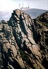
Above the west side of ´Puerto de Navacerrada´ there is a ski trail named ¨Pista del Telegrafo´, going up on the left side of this ski trail to reach its highest point. From there follow wide path through treeless hill to reach group of rocks in order to pass them on the right side avoiding an obvius path going leftwards; will leave us close to a beautiful meadow on the left. From that point the tree covered hill is easily seen. Walk to the foot of it, and follow up any of the trails marked with cairns. Not to follow from foot of hill the marked path with yellow and white signs going leftwards. Passing by the last pines of this side of the mountain and reaching a rocking area to go left to rigth on a sundy path. Keeping on the trail, soon the rocky pile of the seventh peak is in our sight. Climbing to the highest of the seventh peak is easy and worthwhile, on a clear day the view in all directions is very espectacular. To this point 1h.15min. from ´Puerto de Navacerrada´, and it is an easy task to follow the trail and scramble to the other five peaks in the way. The sixth is the lowest from the summit ridge and its top can be hiked easily, the trail around the north side of the the sixth can be confusing. it descends diagonally rightwards to get to the foot of the peak, at this point turns left to reach the fifth. The trail now leaves the large rock of this peak to the left. A little after two rare pines we would came onto two trails, the most hiked one going rightwards directly to ´Collado Ventoso´ (Windy Col), and the one going leftwards passes on the south side of the large rocks that give shape to the Fourth. Keeping up the trail we would be passing soon on the right side of the third peak and the ´Devil´s Window´ situated on its north side. From the Second-Third peaks col, hike up the second and scramble the last bit. Around two hours after start we would have another beatiful sight in all directions. Now we have several different options an all of them star from 2nd.-3rd. peaks col. If we want to climb Majalasna Peak descend to the peak looking SW that rises above a beautiful meadow, from there take the trail going south through the forest to reach ´Navarrulaque´ and ¨Los Miradores de los Poetas¨. To get to Cercedilla we could walk down the mountain road or hike down the ¨Vereda Alta´ trail from ¨Mirador de Luis Rosales´. This is the most recomended option.
The other options start from ¨Collado Ventoso´, 20 min hiking down from 2nd.-3rd. peaks col, looking North, first over rocks and then through forest. Taking the ´Schmid´ trail going Eastwards, marked with yellow circles painted on trees, will leave us 1h. 15min. later back in ´Puerto de Navacerrada´.
Taking the ´Schmid´ trail going SW, marked with yellow circles painted on trees. It is a steep trail, not to confuse with the ´Alevines´ one going left, and it is important to pay attention. 15 min later reaching spring and cross graved road to follow trail, again steep, to reach again road to follow it to ´Las Dehesas´ (1h. 20min.) and in another hour to Cercedilla.

 25324 Hits
 84.27% Score
 18 Votes


Diego Sahagún - Nov 3, 2004 2:26 pm - Hasn't voted
Untitled CommentThere is a possible shelter to the left of the trail between 6th and 5th peaks. It's very rudimentary and is formed by a big rock as roof and others as walls. It's big but has not walls on the front and could let the rain pass through a window between rocks in the S side. The worst thing about this vivy is that faces north although it could be useful in a sudden storm not to get too much wet.
Diego Sahagún - Dec 4, 2007 8:20 am - Hasn't voted
Puerto de Navacerradahttp://www.puertonavacerrada.biz/pueblo/crono/cronolog.htm
Diego Sahagún - Apr 30, 2009 6:46 am - Hasn't voted
AEMET weather forecast for Sierras de Guadarrama and Somosierrahttp://www.aemet.es/es/eltiempo/prediccion/montana?w=&p=mad2
Diego Sahagún - May 21, 2010 8:12 am - Hasn't voted
Lavado de cara para el Puerto de Navacerradahttp://www.elfarodelguadarrama.com/noticia/24311/Comarca/lavado-cara-puerto-navacerrada.html