
|
|
Mountain/Rock |
|---|---|
|
|
38.30710°N / 119.6913°W |
|
|
10641 ft / 3243 m |
|
|
Overview
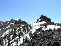
Night Cap Peak is located on the northern boundary of the Emigrant Wilderness Area, not far from CA Hwy 108 and the Sonora Pass. There are some dramatic cliffs and spires along the summit ridge that, from a distance, give the appearance of a night cap. That is likely how the peak got its name.
As a climbing destination Night Cap Peak is best suited for peakbagging, as it is comprised of volcanic rock and therefore not safe for technical rock climbing. It is mostly a slog to the summit, but a worthwhile hike nonetheless. There are rewarding views of the Emigrant Wilderness Area towards Big Sam, Kennedy Peak and Lake, Relief Peak and Reservoir and Granite Dome.
Note that for some reason the summit log was placed on the peaklet just west of the true summit.
Getting There
From Sonora, go east on Highway 108 for 55 miles to the Kennedy Meadows turnoff on the South side of the highway, six miles east of Dardanelle. Turn right and follow the road a mile to the well-signed parking area. Day hikers can park .5 mile farther down the road near the Kennedy Meadows Resort.

Route Descriptions
There are 3 potential routes to the summit, as described below.
1) Standard Route
The standard route follows Night Cap Trail from the west. This is a small use trail that starts about 0.2 miles from the Kennedy Meadow trailhead near the resort's water tank. The trail is seldom used and not very obvious. There is sometimes a trail sign, but it is missing more often than not.
Follow the trail to its apex around 8,000ft. Leave the trail when it starts to decend toward Kennedy Lake and follow the ridgeline to the summit. (Approx 8 miles round trip.)
2) From the South
There is a gully and stream that flows down the south side of the peak to the Kennedy Lake Trail, abut 1/4 mile from the Night Cap Trail split. This route might serve as a good descent route. It can also be used to ascend the peak but it is almost entirely sand and scree, with some slightly larger talus on the upper part of the route. As you near the summit, aim for the saddle between the true summit and the peaklet to the west. (Approx 11 miles RT from Kennedy Lake.)
3) From the East
For the more adventurous, you can attmept the peak from the east. Starting at Chipmonk Flat, follow the stream north for 3 miles and ascend the saddle on the southeast side of Night Cap Peak. This route is entirely off trail and some Class 3 climbing is required to gain the saddle. The southeast side of the summit above the saddle looks unclimbable. From the saddle, the easiest route may be to traverse the talus field towards the west peaklet and gain the ridge from the western saddle. (Approx 7 miles RT.)
Red Tape
No permits are needed to hike the Night Cap Peak trail. Wilderness permits are required for anyone staying overnight in the Emigrant Wilderness.
Permits can also be obtained from any Stanislaus National Forest Ranger Office. Only one permit is needed for continuous trips passing through more than one wilderness area. Only one permit is needed per group up to 15 people.
When To Climb
Highway 108 usually opens at Memorial day and closes the first major storm in October. Check road conditions before departing. I needed my crampons and ice axe. Hike the southern side for less snow and less exposure.
Camping
There are plenty of places to camp near Night Cap Peak.
There are 2 fee campgrounds at Kennedy Meadows; Bakers and Deadmans campgrounds. These are the closest campgrounds if taking the standard route from the west.
Primitive camping is also available on the way to the summit.
If you wish to attempt the peak from the east, you can camp at Chipmonk Flat on Hwy 108. There are several no-fee campsites here. Permits are not required to camp, but you may need a campfire permit depending on the level of the fire conditions.
There are numerous additonal campgrounds along Hwy 108. Permits are not required as the land immediately adjacent to Hwy 108 is not in a designated wilderness area.
Mountain Conditions
Contact Stanislaus National Forest, Summit Ranger District for mountain information. (209) 965-3434
The following links provide additional information on local conditions.
Hwy 108 road conditions.
Conditions Page of the Stansislaus National Forest.
External Links
- Emigrant Wilderness web site
Emigrant Wilderness web site: USDA Forest Service, Stanislaus National Forest - Kennedy Meadows Resort
Kennedy Meadows web site provides directions to the trailhead and rates for cabins and pack (horse) trips.
fedak - Feb 17, 2005 1:48 pm - Hasn't voted
Untitled CommentThe Night Cap trail (which diverges from the main trail shortly after the Kennedy Meadows Resort) is described in detail in Ben Schifrin's "Emigrant Wilderness and Northwestern Yosemite".
The trail does not go to the peak itself and tops out well short of the ridgetop before decending towards Kennedy Lake. Ascending to the ridge from the apex of the trail will put you about 3/4 mile west of the highpoint at the east end of the ridge.