
|
|
Mountain/Rock |
|---|---|
|
|
38.43476°N / 119.57023°W |
|
|
Alpine |
|
|
Hiking |
|
|
Summer, Fall |
|
|
10571 ft / 3222 m |
|
|
Overview
Tucked away on a north end of the ridge it shares with Lost Cannon Peak 11,099’, Fish Valley Peak is an oft forgotten summit. It has a prominence of approximately 350’ and has excellent summit views.
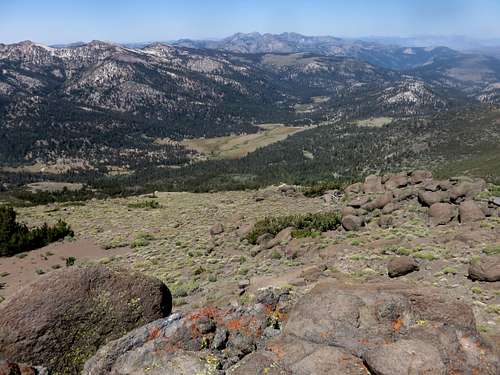
Fish Valley seen from Fish Valley Peak
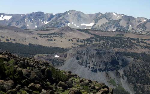
White Mountain ridge from Fish Valley Peak
There is only one reasonable approach, which is from the south from the Silver Creek Meadows. This is the same approach commonly used for Lost Cannon Peak and Wells Peak 10,833’. This means that to reach the summit, you have to go to a higher elevation than the summit. This is why Fish Valley Peak is often combined with Wells Peak and/or Lost Cannon Peak.
Despite being overshadowed by its neighbors, Fish Valley Peak is a respectable peak, and a worthy destination.
Because it is approached via the south, Fish Valley Peak, along with its neighbors Wells Peak and Lost Cannon Peak, can generally be hiked starting in late June/early July through October. This of course depends on the snow levels. But the approach from the south allows early summer hikes. I recommend September or early October.
Getting There
Take Highway 395 and go west at the junction with Highway 108. The entrance to the trailhead is at the Marine Corps Mountain Warfare Training Center (MCMWTC). This is about four miles west of Highway 395, and 10 miles east of Sonora Pass. The MCMWTC is not a military base, per say because the area is shared with the U.S. Forest Service and hiking in the mountains behind the MCMWTC is open to the public.
Take the dirt road heading towards the mountains. After about 1 ½ miles up the road, head left at a junction and continue up the road another two miles. Then take a left towards the Silver Creek Meadows, which is a mile from the turn-off. This is a good dirt road. 4WD and higher clearance is useful, but not required to reach the trailhead.
Route Information
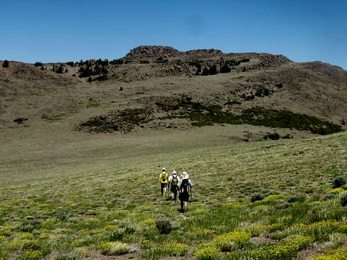
Heading up towards Fish Valley Peak
A trail heads steeply up the slope from the trailhead. After about 2 ¼ miles, an open area is reached. Wells Peak is on the left. Head up to the saddle. The next summit is Point 10,973’. It is advisable to go up and over this summit. That is reached about 3 ½ miles from the trailhead. Fish Valley Peak is a little under 2 miles away. Once on the summit of Point 10,973’, descend steeply down and go up and over another hill. Fish Valley Peak is in your sights. It is odd to summit a peak after going up and over a higher summit. But this is the shortest, most straight-forward route.
The elevation gain one-way is about 3,100’. You have to gain elevation on the way back, but if you head to the left side of Point 10,973’, you can avoid over 250’ of gain on the way back, making for a total gain of about 4,000’ if just hiking Point 10,973’ and Fish Valley Peak. The total distance is about 10 ¾ miles. If adding Wells Peak, it is another 630’ of elevation gain and a mile of hiking distance.
Red Tape
No permit is required to hike in the mountains behind the MCMWTC. You will see an armed guard at the entrance, and you may have to present you I.D. Some people camp at the trailhead which has no amenities besides a row of porta-potties.
hgrapid - Aug 19, 2016 2:32 pm - Hasn't voted
Re: Wrong nameWhoops, I got it right in the photos and most of the text. It was just a brain fart I suppose. Thanks for the catch!