
-
 16734 Hits
-
 87.76% Score
-
 25 Votes
|
|
Mountain/Rock |
|---|---|
|
|
38.33730°N / 119.951°W |
|
|
6083 ft / 1854 m |
|
|
Overview
 |
 |
Getting There
The summit can be reached in several ways:(1) By following a 4WD road across the Middle Fork at Donnell Powerhouse, up along Shoofly Creek to Bummers Flat (I did not make up these names, honest!). From Bummers Flat an old pack trail leads past Dome Rock. Cross country through slabs and brush from there to the summit of Broad Dome.
(2) From the Donnell Dam, thrash across the base of Weeping Wall and up through brush, slabs and cliff bands to the top.
(3) Starting out of the boat, ascend any of the incredible routes on Atlantis Wall. To date there are four known routes on the wall -- from east to west, they are:
Falcons of Neptune (IV, 5.11c)
Moonshadows (IV, 5.11a)
Potter's Route (IV, 5.10)
Sirens of the Stanislaus (V, 5.10 C2)
Approach:
Travel east on Highway 108 from the town of Strawberry for about 4 miles. Turn left (south) onto Beardsley Road. Follow this for about 1 mile to the second dirt road on the right. Turn right here (USFS 5N06) and follow this road for about 2.1 miles to a large flat area where the road forks. To approach via Dome Rock, (option 1 above) take the left hand fork. To approach the climbs on Atlantis Wall, follow the right hand road, USFS road 5N09X. Drive this deteriorating, high-clearance adventure for about 8.5 miles to where it ends at a locked gate. This is where the fun starts.
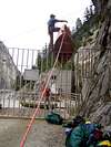
Unload your canoe and gear, and pass them through the gate. From here, transport these loads of equipment for about 0.3 miles to a second high steel gate. Hoist the boat over the gate, pass the gear through, and walk out onto the dam. Still interested?
If the reservoir is spilling, it is possible to launch the canoe directly into the water from the top of the dam. Otherwise, use your ropes to lower the boat and your gear approximately 30-45 feet to the spillway, and launch from here. Atlantis is the huge wall rising directly out of the water on the north side of the reservoir.
Warning: Donnell Reservoir is nearly 300 feet deep at high water, and in most places the rock walls drop sheer into the deeps. What this means is that there is seldom a shoreline, nor a lake bottom, handy as a "safety net" in the event of a boating mishap.
Furthermore, the reservoir regularly is blasted by upcanyon winds during the day as the lowlands heat up. Gales of up to 40 mph are not at all uncommon, turning the surface of the water into a whitecapped maelstrom with 3-foot swells. This is one of the few approaches in the United States that involves Class 2 whitewater without an accompanying river current. PFDs are mandatory and should be worn at all times.
Before you head into this area, take a good look in the mirror. If after reading about this place you are still interested, you have no one to blame but yourself. In that case I recommend you check yourself into an institution for some quality therapy time. If on the other hand common sense gets the better of you, great. Go climb something a little less adventurous, and a little more crowded, like Mt. Dickey in Alaska or Mt. Waddington in the Canadian Coast Range.
 |  |  |  |  |
Red Tape
Given the obstacles to reach this place, there is refreshingly little red tape. Access across the dam is not prohibited, wilderness permits are not required. A USFS fire permit (good for a calendar year) is required to build fires, and is available at no charge at the USFS Ranger Station in Pinecrest. Campfires are subject to the usual restrictions during fire season. Fishing is permitted with a California fishing license.When To Climb
The summit can be reached any time of year when the roads are passable. Many of the dirt roads are closed at locked gates during the winter storms.Climbing on Atlantis Wall is subject to closure from January 15 through July 31 to protect nesting Perigrine Falcons. Please respect these closures to help out these incredible creatures.
Camping and other issues
Undeveloped camping is free at the end of the road. No water or toilet facilities are available.The nearest supplies (including climbers' chalk) are available at the General Store in Strawberry. This is also the location of the nearest reliable telephone.
In the event of an emergency, the nearest pay telephone (which works sporadically) is located near Cow Creek, 1.3 miles east of Beardsley Road. Drive Highway East 108 until 200 yards past Leland Creek Road, and turn right at the phone symbol.
The nearest cellular telephone reception is approximately 6 miles back up the road from the dam, at a microwave reflector tower located where the penstock from the dam begins its dramatic descent to the Donnell Powerhouse at the head of Beardsley Reservoir.
 |  |
External Links
- Sonora Pass Climbing
Web page dealing with climbing in the Sonora Pass area, including new routes, with useful links to highway conditions, weather, reservoir levels and other useful information.
brutus of wyde - Oct 4, 2005 11:26 am - Hasn't voted
Untitled CommentThanks, Munge. Added to the page.
mungeclimber - Oct 2, 2005 11:55 pm - Hasn't voted
Untitled CommentAs of 10/1/05 there is cellular reception, barely, at the first Microwave tower a few miles from 108 down the road toward the reservoir.
brutus of wyde - Oct 4, 2005 11:26 am - Hasn't voted
Untitled CommentThanks, Munge. Added to the page.