

|
|
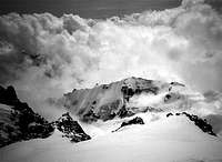
Mountain/Rock |
|---|---|
|
|
42.67000°N / 44.51000°E |
|
|
14320 ft / 4365 m |
|
|
Overview
Ortsveri is a mountain standing in the shadow of its much higher neigbour, Mt Kazbek. Being almost 800 m lower than Kazbek, it seems not an obvious climbing goal. However. Ortsveri is frequenly visited as acclimatization climb by climbers who want to climb Kazbek.
The bedrock is volcanic (mostly Trachyte to Andesite) and the ridge of the Ortsveri is the remnant of the flank of a large volcano, of which the top was situated around the current cone of the Kazbek. The Gergeti valley -and glacier- nowadays seperate the two mountains.
It is uncertain when the mountain was first climbed, but nowadays the top is frequently visited which is, given the relative ease of the standard route, no surprise. The normal route is rated 2 (Russian grade), but a variety of routes from up to 4 are possible from the north west snow and ice face. Due to the instability of the the volcanic bedrock, rockclimbing is not recommended and even dangerous here
The standard route starts at the lower section of the Maili Plateau, where the Gergeti Glacier curves to the north. from there the route leades up over the snowy and icy north-west face (max ~40 deg) to the ridge. Be aware of crevasses! From there, following the ridge to the top normally poses no difficulties. The route is entirely over snow and corresponding equipment is required. The whole climb from the refuge (see below) to the top and back will take approximately. 4-5 hrs. Though an easy climb, standard mountain hazards as bad visibility, heavy snowfall or strong winds remain possible, so stay alert.
 |  |
Getting There
From the town of Kazbegi, down in the valley, a well marked trail leads up to the Trinity curch and beyond in the direction of the hut "Meteostation", a former Sovjet meteorological observation station. Folow the trail to the front of the glacier. Next, trek the glacier and cross it diagonally (direction WNW) to the foot of the Kazbek. This direction will lead you between two large crevasse fields. However, at this low altitude most crevasses are easily spotted and should pose no problems. At the south foot of the Kazbek, you can see the hut lying above you overlooking the glacier. There is a trail from the glacier to the hut that starts directly below it. For details concerning the hut look below. From there you can start your climb following the glacier to the lower Maili Plateau. You can traverse the Glacier to the foot of Ortsveri at more than one point, depending on the degree of snow covering and the time of the day (severe rockfall during daylight, so stay away from the cliffs after sunrise! esspecially the sun facing ridges).The Starting town of Kazbek can be reached easily from Tbilisi following the Georgian Military Highway. There is a Taxi-bus service between Tbilisi and Kazbegi. Kazbegi has a good Hotel and many families who rent rooms. Kazbegi can also be reached from Russia following the road between Vladikavkaz and Kazbegi. However, for this route you have to cross the border from Russia into Georgia. According to another SP member this border may be closed for foreigners to cross. The current quite frozen relationship between Georgia and Russia will certainly complicate matters more. Get yourself up-to-date on the current situation before you intend to approach this region from Russia. The Lonely Planet Thorn Three is a good place to ask . You can find the site in the "Links" section of this page.
The are several Georgain organisations offering mountain guides for this region. I think you can also find a guide downtown in Kazbegi, but it may cost you some research to find one and the degree of experience of a local guide can be doubtful. If an organisation has a decent website and had some years to mature, you will most likely get experienced and good guides.
 |
Red Tape
All Georgian peaks are fee-free, and that of course includes Ortsveri.When To Climb
 Panorama
The climbing season runs from mid-spring to mid-autumn, but july and august are the best months. Winter climbs are possible but only recommended if you are an experienced climber.
Camping
Camping is allowed anywhere. Sleeping in this hut is $ 10,- a person for which you can expect a bed, streaming water (during daytime) and cooking facilities (bring your own fuel!). Camping in the vicinity of the hut is allowed. You may be charged if you want to use the facilities of the hut. Note that outside the main season the hut may be closed. The key is kept down in Kazbegi. Ask around there before you start.Mountain Conditions
For more information you can also visit the Kazbek page on summitpost. For a regional weather forecast from the Russian Meteorological Office:Weather Forecast for the Caucasus
Maps
Maps are available at Geoland in Tbilisi, the Capital of GeorgiaPurtseladze St. N3, Tbilisi , Georgia , 380008
Tel: 921191, 921494
Fax: 921494
E-mail: info@geoland.ge
geoland.ge
Thanks to Thin Air.
Safety
The recent war and the frozen relationship between Georgia and Russia has not done been beneficial for general safety in the Caucasus. Monitor the situation before you go. Robberies have been reported in Savaneti (North-west Georgia), but The Kazbegi region is seems to be largely devoid of crime. Except for a single valley bordering Chechnnya, all places in Georgia are free for climbers to visit. To be sure, check the latest information by contacting your government for the latest travel advice for Georgia.External Links
- Kazbek page on Summitpost by Alexclimb
This link shows you more information about Ortsveri's giant neighbour Kazbek. It also gives some information regarding the climbing history of the region.
- Weather forecast from the Russion Meteorological Survey
This is page provides a 1 day weather forecast for the Caucasus region. It is provided by the Russion Meteorological Survey and posted by elbrus.org.
- The Lonely Planet Thorn Tree
Here you can ask for information about bordercrossing and safety in the Russian-Georgian region.