
|
|
Mountain/Rock |
|---|---|
|
|
43.18654°N / 42.74595°E |
|
|
Mountaineering |
|
|
13093 ft / 3991 m |
|
|
Overview
Djan Tugan is a beautiful pointed peak in the Adil Su valley in the Caucasus. From far away it looks very difficult, but there is a quite easy route up via a couloir, which is a 2B Russian gradeIt is a one of the more popular peaks in the area, probably number two after Gumachi. The difficulties climbing the peak is 1). Some very nasty crevasses en route. 2). Potential objective dangers on the way to the peak and also the last part on the climb. 3). The normal camp spot before attacking is on a snow field full of hidden crevasses. Be very careful here. We saw the result of a bad accident up there.
 |  |  |  |  |
Getting There
Most people arrive in Mineralniye Vody when going to the Caucasus. From there the most convenient mode of transport is of course to go by pre-rented mini buses, but there are also good bus connections from Min Vody, to the main valleys of the Caucasus. If going by bus, opt for one heading for Terskol or Elbrus Village. Sometimes you have to change buses on the way.Many people also hitch hike from Min Vody. Sometimes it's a free ride, but more commonly you end up going in a mini-bus where you have to pay a small fee.
When in the main valley of Elbrus, jump your transport at Camp Adil Su. There is a small camp ground, hotel, bar, shop and restaurant there. You can also put excess gear in the restaurant's "gear room for a small fee.
Walk on a steep asphalt road for 4 km. At the end of the asphalt there are some good restaurants and shops. Useful for last minute shopping.
Take a left at the junction and continue along a dirt track. After another 4 km you'll hit the entrance of Adil Su National Park, where you have to register. From here on, it's normal trekking along nice streams to the base camp of Djan Tugan.
If you don't have a map for the area, ask for routes at the base camp. The officials staying there knows where the crevasses en route are dangerous.
Walk up the valley on the left hand side of the base camp and continue until you hit the glacier. You better stay in the middle of it as the right hand side/Djan Tugan side is dangerous due to rock and ice fall.
Walk towards the gap in between a small peak and Djan Tugan to the pass. The way up to the pass is steep, icy and there are some huge crevasses just before the steepest section starts. When on the pass, walk towards the foot of Djan Tugan. There is a big snow field here which is good for an attack camp. Be very careful here!
There are crevasses also on the field itself.

A map of the area. It may be a bit hard to read. Large version here!
Red Tape
The fee of entering Adil Su National Park is at the time writing € 0.6/day and it's payable in Russian rubles at the entrance of the park.You have to have "Adil Su" written on your visa invitation to Russia or the military will not let you pass the checkpoint in Adil Su Border area. The army checkpoint is located roughly a km after the entrance of the park.
There are no peak fees.
 |  |  |  |  |
When To Climb
The general climbing season is May to September, but the peaks are climbed at all times of the year. Winter or off-season climbs reduce the rock fall and crevasse danger which is a potentially a hazard on the approach to the mountains.The couloir on the normal route is hazardous when it's sunny. Mini-avalanches and falling rocks are common.
 |  |  |  |  |
Camping
Camping is allowed everywhere in the natural park. No fees. There are basic huts in the base camp, but they are in general used for either the rangers or persons who for one or the other reason need to stay inside a hut, i.e. have had an accident or are in a bad condition somehow.The base camp at the foot of the snow fields and glaciers is grassy and there are fresh water around. What´s a bit intimidating is the piles of garbage which just lays there waiting to be picked up and brought down by the park authorities.
 |
Mountain Conditions
The locals in the area seems to be very updated on the conditions higher up in the valleys and the administrative people staying in base camp have all the information you need about the conditions on the mountain. You can also ask at the Park Head Quarters and at the army check point on the walk in to the peak. |  |  |  |  |
Routes
The normal route starts at the snow field on the mountain's east side. Negotiate the rocky little step and continue up the snowslopes. Usually there are snow on the whole ridge, but you may have to climb some rock on the way. There is a snowy shoulder which is quite wide until it gets steeper and you enter the couloir.The final part to the summit is a constant 60-65 degree climb on snow or ice. I was recommended to stay on the right hand side on this section.
The North-West ridge route is a harder route at 3B, which includes mixed climbing and some airy sections. The acess to this route starts directly from the base camp. Walk straight up the little tung of snow and continue past the huge boulders where the snow tung is almost connecting to the glacier behind the "base camp ridge" in the north.
There are some other routes on the mountain, the most difficult is a steep and hard 4B. The south face is supposed to be a nice rock climb.
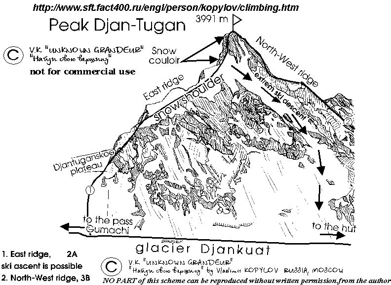
A simple sketch of the routes of Djan Tugan
 |  |  |  |
Safety in the Caucasus
The Adil Su valley is very safe and is under strict control of the army. You are very close to the Georgian border and don't stray to far south. You will end up in hassle if caught or even seen by people "from the other side".The Book
Kopylov, the person who really knows the mountains of the Caucasus has written a book called Forbidden Mountains - The most beautiful Mountains of Russia and Central Asia.Gear Shop
There's a great gear shop very close to the turn off to the Adil Su valley. It's located along the main road in the Terskol Valley. I think it's called "AlpIndustria".You can find basically everything you'll need here to very affordable prices.
Corax - Feb 6, 2006 9:04 am - Hasn't voted
Untitled CommentHi Michael!
This photo? It's not mine.
I would say it could be from the summit. The whole peak and the surrounding areas were very snowy when I was around, so it looks different, but I would say it can be shot from the summit.
Thanks for the feedback.
I'll have a look at the Kirpich page now.
michaelhaifa - Jan 17, 2006 12:02 pm - Voted 10/10
Untitled CommentHello, Corax
First of all wish you a good luck in 2006.
On your Djantugan page (which is truly fantastic) you have a picture with a climber wearing a yellow helmet, with Elbrus seen on the background. Caption says that it is a view from the summit. Judging by proximity of mountains around it is likely view from the slope of Djantugan but not from the summit.
By the way I completed my Kirpich page and you might have some suggestions how to improve it.
Take Care!
Michael
Corax - Feb 6, 2006 9:04 am - Hasn't voted
Untitled CommentHi Michael!
This photo? It's not mine.
I would say it could be from the summit. The whole peak and the surrounding areas were very snowy when I was around, so it looks different, but I would say it can be shot from the summit.
Thanks for the feedback.
I'll have a look at the Kirpich page now.
kola - Jan 8, 2008 5:22 am - Voted 10/10
no more snow in the couloirOn the 4th Aug 2007 there wasn't any snow in the couloir, so the final part was just rocks...quite unstable rocks. The left part seemed easier, and we succesfully followed it to the top. It's good to have a 60m rope for abseiling. There are some webbings around rock blocks, spaced about 30m form each other, but the webbings are old, and blocks unstable, so one should pay attention and check before loading. and another thing for all of russian border zone caucasus: if you don't have the valleys mentioned in your visa or invitation, you should go to HQ of border guards in Nalchik and get the permission there. I'll write all the deatils of this procedure sometime this week. It's easy if you know what to do, where to go and prepare some papers at home.
Corax - Jan 13, 2008 6:41 pm - Hasn't voted
Re: no more snow in the couloirThanks for the input. When you have added the rest of the details, I'll put the info on the page.
Jaco - Jul 4, 2019 11:49 am - Voted 9/10
Re: no more snow in the couloirHi Corax. Thanks allot for all the info. My father and I are heading for the Valley in the last week of August and this post sure helps allot. The only problem is that I cant seem to access the link to the route descriptions. Also not for Djan Tugan. Can you possibly help me here?
Corax - Jul 8, 2019 2:42 am - Hasn't voted
Re: no more snow in the couloirSorry for the dead links. I have pointed them to the right sources. You should now be able to access the simple route sketch and a page with more info about the Caucasus.
Jaco - Jul 9, 2019 1:59 pm - Voted 9/10
Re: no more snow in the couloirThank you Corax, really appreciate it.