
-
 13848 Hits
-
 83.1% Score
-
 16 Votes
|
|
Mountain/Rock |
|---|---|
|
|
64.00000°N / 21°W |
|
|
Hiking, Mountaineering |
|
|
Summer |
|
|
1808 ft / 551 m |
|
|
Overview
 View of the Hvitá from Summit
Ingólfsfjall - - pronounced something like “IN-koalfs-fyatl” - - is one of the large blocks of rock that rise out of nowhere in southwest Iceland. Though it’s not very high, it’s noteworthy because it dominates a relatively low region and therefore gives you 360º views of the country.
Two large rivers, the Hvitá (White River, pronounced “KVEET-ow”) and Sog (“soak”) flow together beneath Ingólfsfjall. There they take a new name (Ölfusá, “ULL-foos-ow”), and then form an estuary a bit below the town of Selfoss and out to the ocean.
The mountain is named after Ingólf Arnarson, the first settler of Iceland. He spent his third winter in Iceland at a camp below the mountain. The area where he must have camped is well-watered and grassy, and looks like a good place to bunker down for the winter - - unlike most of the rest of the country.
Fun fact: if you take the East Route (see link), you'll cross a confluence point, at exactly 64º N, 21º W.
Getting There

Access is easy if you’re staying in Reykjavík or nearby areas. The trailhead is just north of Selfoss on a stretch where Highway 35 and Highway 36 merge. If you’re coming from Keflavík airport or from Reykjavík on the Ring Road (Hringrutan, Highway 1), turn left on Highway 35 just before Selfoss. If you enter the town or cross the bridge, you’ve gone too far. If coming from Þingvellir National Park, a major tourist site, you’ll take Highway 36 down the east side of the lake (Þingvallavatn) south to Highway 35. Ingólfsfjall will be clearly visible on your right.
 Moss Campion
Perhaps a kilometer or two south of the intersection of highways 35 and 36 you need to look for a small road (Highway 350) just south of the bridge over the Sog river. (From the Ring Road, this will appear less than a kilometer north of a scenic pullout.) Highway 350 goes off into nowhere, but there’s also a driveway there that goes to the farm of Alvíðra. That farm is now a research station for some institute, and they’ve set aside parking for a few cars at a trailhead (see the East Route for a description of the trail). There’s a diagram of the trails and the East Route in the parking lot, though it’s not all that helpful.
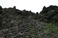 Looking up the Chute
If you want to know more about the geology of the mountain, there’s a good display at a road turnout just south of the farm on Highway 35.
Red Tape
 Summit Marker
As far as I can tell there is no red tape in Iceland, nor anyone who would enforce it if there were.