
|
|
Mountain/Rock |
|---|---|
|
|
38.95470°N / 120.1498°W |
|
|
El Dorado |
|
|
Hiking |
|
|
Spring, Summer, Fall, Winter |
|
|
9234 ft / 2815 m |
|
|
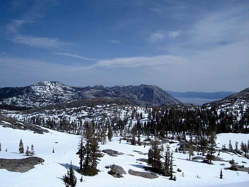
Overview
Phipps Peak is located west of Lake Tahoe, a short distance from Emerald Bay. Its close proximity to Highway 89 allows for year around access. The peak provides fantastic views of the Desolation Wilderness. The great views from the summit can be had for minimal time and effort.The summit can be reached via easy class 1 terrain from several trailheads on Highway 89. The peak can easily be hiked in a day. Several backcountry camping opportunities exist in the area for those looking for a longer trip.
Phipps Peak is on the TAHOE OGUL PEAK LIST.
 Phipps Peak
Getting There
| Trailhead | Route | Difficulty | Elevation Gain | One Way Distance |
|---|---|---|---|---|
| Bayview Campground | Trail | Class 1 | 2400ft | 8.5 miles |
| Eagle Falls | Trail | Class 1 | 2600 ft | 8.5 miles |
| Eagle Falls | Cross Country | Class 1 | 2600 ft | 3.5 miles |
| Meeks Bay | Trail | Class 1 | 3000 ft | 11 miles |
BAYVIEW CAMPGROUND (38.945° N, 120.010° W): Located on the west side of Highway 89, approximately 5 miles north of Camp Richardson. Follow the trail west past Granite Lake and across the saddle between Maggies Peaks. After 2.8 miles the trail converges with the Eagle Falls trail. Continue west for another 2.2 miles where the trail meets the PCT by Middle Velma Lake. Head north on the PCT for 1.2 miles to the junction with the Phipps Pass trail. Head west on the Phipps Pass trail to approximately 8800 feet. At this point you must leave the trail and head for the summit.
EAGLE FALLS (TRAIL) (38.955° N, 120.110° W): Located on the west side of Highway 89, approximately 6.5 miles north of Camp Richardson. Follow the trail west past Eagle Lake. After 2.6 miles the trail converges with the Bayview Campground trail. Continue west for another 2.2 miles where the trail meets the PCT by Middle Velma Lake. Head north on the PCT for 1.2 miles to the junction with the Phipps Pass trail. Head west on the Phipps Pass trail to approximately 8800 feet. At this point you must leave the trail and head for the summit.
EAGLE FALLS (CROSS COUNTRY) (38.955° N, 120.110° W): Located on the west side of Highway 89, approximately 6.5 miles north of Camp Richardson. Follow the trail west to Eagle Lake. Follow a use trail around the west shore of the lake. Continue up the canyon until approximately 7400 feet. Turn north and follow the draw to approximately 8500 feet. Head directly towards the summit from this point.
MEEKS BAY (38.037° N, 120.126° W): Located on the west side of Highway 89, approximately 2.5 miles south of Tahoma. Follow the trail south, reaching Lake Genevieve after 5.5 miles. Continue south until Phipps Pass is reached after another 4.6 miles. Leave the trail and head directly towards the summit from here.
 Falls Above Eagle Lake
Red Tape
Permits are required for day and overnight use in the Desolation Wilderness. Day permits are free and can be self issued at the trailhead. Overnight permits require a fee and must be picked up at one of the following locations:PACIFIC RANGER DISTRICT
Located four miles east of Pollock Pines on Highway 50. 7887 Highway 50, Pollock Pines, CA 95726. Phone: (530)644-6048. Winter: Weekdays only. Monday through Saturday as of late April. Summer: 7 days a week, 8:00 a.m. to 4:30 p.m. through October.
LAKE TAHOE VISITOR'S CENTER
Located three miles north of the Highway 50/89 junction at South Lake Tahoe, on Highway 89. Phone: (530)543-2674. Open summer only.
LAKE TAHOE BASIN MANAGEMENT UNIT
Located two miles east of the Highway 50/89 junction in South Lake Tahoe on Highway 50. From the highway turn right on Al Tahoe Blvd. and then turn right at first signal. 35 College Drive, South Lake Tahoe, CA 96150. Phone: (530)543-2600
For more information regarding permits, click HERE.
When To Climb
Highway 89 is open year around allowing all season access to peak. While the Eagle Falls parking the lot is not plowed in the winter, the large turn out next to Highway 89 is. The peak is generally snow free from July through September. The area is popular with hikers, snowshoers, skiers, and tourist: do not expect solitude in any season.Camping
Developed campgrounds can be found at Meeks Bay, D.L. Bliss State Park, Emerald Bay State Park, and Bayview. Fees and facilities vary.The area also offers excellent backcountry camping opportunities with its many lakes. Eagle Lake lies in a special management area, please camp in the designated sites only.
Mountain Conditions
The Desolation Wilderness is subject to a variety of weather conditions, including heavy snowfall in the winter. Weather forcast can be found HERE.The avalanche advisory can be found HERE.
fedak - Aug 11, 2009 9:24 pm - Hasn't voted
AdditionsThe summit is a quarter mile from the nearest point in the TYT (with a final 350ft of elevation gain) If you are heading up the TYT from Velma Lakes, you will be able to see the summit and make a judgement call as to when to head up. It is not necessary to go all the way to Phipps Pass. The cross-country leg is easy class 2 (mostly a mixture of broken slabs and talus) The summit block itself is a 15ft class 2 (or very easy class 3) talus/rock scramble. Nitpick: The cross country route from Eagle Lake, by definition, is class 2 rather than class 1.