
|
|
Mountain/Rock |
|---|---|
|
|
56.61233°N / 4.85192°W |
|
|
Hiking, Mountaineering, Scrambling, Skiing |
|
|
Spring, Summer, Fall, Winter |
|
|
3635 ft / 1108 m |
|
|
Overview
 Creise from the summit of Meall a'Bhuiridh
 Meall a'Bhuiridh from the north
Meall a’Bhuiridh (pronounced Mowl a vooree) is located within the northern area of the Black Mount Hills Range. The Black Mount Range runs from Loch Tulla and Loch Dochart in the south to the River Etive and the Kingshouse Hotel, at the start of Glencoe, in the north.
Meall a’Bhuiridh (translation: Hill of the Roaring Stag) stands at a height of 1108m/3635ft and is the highest peak within the Black Mount Range. This peak is classified as a Munro and is number 45 in the Munro heights table.
Meall a’Bhuiridh can be climbed from the south via Stob Ghabhar in a route over the entire range known as the Clachlet traverse (2 days or a very long day) or from the north via a route that follows the eyesore of the chairlifts and tows of the Glencoe Ski Centre (approx 4-6 hours).
It should be noted that if you intend to cross Meall a’Bhuiridh’s western ridge that connects to Creise(1100m) and Clach Leathad(1098m) to add these summits to your day, that this ridge is steeper and narrower than indicated on the maps and crampons are essential in winter as this section is prone to bad icing.
During the skiing season you could ascend/descend via the chairlifts, however I would advise going when the skiing season is over and when there is still plenty of snow on the slopes, giving you the pleasure of an entire ski slope to yourself. Whether you are an actual skier or a trainee tobogganist in waterproofs like me, you will enjoy the descent.
Glencoe Ski Centre
 Top section of the peak/ski centre
Glencoe ski centre opened in 1960 and was the first commercial ski-ing operation in Scotland. Today, it is probably not as frequented as it has been in the past with the opening of newer and more up to date operations, but the open corrie above Coire Pollach still holds an excellent amount of snow into the middle of Spring if the snow has been heavy enough over the winter months. The start of Glencoe ski centre is only 1km away from the A82 road and from there a serious of ski lifts and tows will take you to within 5 minutes walk of the summit cairn.
Getting There
 Looking over the Black Mount
CAR
From Glasgow take the A82 road via Loch Lomond northbound direct to Glencoe ski centre at the start of Glencoe. Glencoe can also be accessed from Stirling, Perth or Edinburgh by joining the A85 road and following this until joining the A82 northbound.
RAIL
From Glasgow Queen Street station take the West Highland Railway line to Bridge of Orchy. From here, you could hike towards the south of the Blackmount or hike/hitch/catch bus the remainder to the Kingshouse in Glencoe. Train timetables are available here
BUS A bus service runs daily from Buchanan Street bus station in Glasgow to Fort William, via Glencoe, and then to the Isle of Skye. A full timetable is available here
Red Tape
There is no red tape in Scotland due to the Land Reform (Scotland) Act 2003 which incorporated the Scottish Outdoor Access Code. This code, which commenced on the 9th of February 2005, has established statutory rights of access to land and inland water for outdoor recreation.
The Land Reform(Scotland) Act 2003
Scottish Outdoor Access Code
The following aspects should be taken into consideration when you are in the Scottish countryside;
- Seek local advice in regard to deer stalking or grouse shooting activities
- Ensure that all gates are closed behind you
- During the lambing season (March to May) ensure that all dogs are kept on a lead
- Please refrain from feeding or annoying any animals
- Limited parking space is available at the start of many routes, please ensure that you are not blocking a road and/or entrance
- Parking is provided at the start of some routes by the local farmers, it is polite to ask if you can use this facility
- Try to refrain from crossing fields with animals and/or crops if an alternative route is available
- Ensure that you treat the local environment with care by leaving it as you found it and by taking any litter home with you
- Any camp fires should be carefully watched and only used away from dense forest areas
Accommodation
 Early stage of a mountain stream.
 Creise and Stob a'Ghlais Choire
The two best possible places to base yourself if attempting this peak, which are dependant on your chosen route are; Bridge of Orchy and Glencoe.
Bridge of Orchy
There are two hotels in Bridge of Orchy. There is the Inveroran Hotel at the foot of Loch Tulla and there is the Bridge of Orchy hotel Wild camping is permitted by any of these two hotels.
There is also a bunkhouse Bridge of Orchy bunkhouse
Glencoe There are two hotels in Glencoe. Clachaig Inn and Kings House hotel. Only the latter hotel allows wild camping within their grounds as long as you are well behaved and to be honest has an excellent spot for this.
There is also the following campsites/hostels
Glencoe Independent Hostel
Red Squirrel Campsite
Invercoe lodges and campsite
Glencoe Youth Hostel
Books and Maps
 Extract Harvey's Map:Glencoe. Red=Ascent/Descent, Blue=Optional extra peak
Books
The Central Highlands by Peter Hodgkiss Scottish Hill and Mountain Names by Peter Drummond The Munros by Cameron McNeish The Munro Almanac by Cameron McNeish Scottish Mountains on Ski by Malcolm Slesser The Scottish Peaks by W. A. Poucher
Maps
Harvey Superwalker Map: Glencoe OS Explorer Map sheet: 384 Glen Coe & Glen Etive OS Landranger Map sheet: 41 Fort William & Glen Coe OS 1:25 000 scale sheet 94: Glen Coe, Rannoch Moor & Crianlarich
Mountain & Weather Conditions
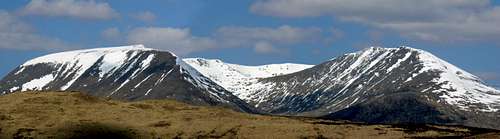 Clach Leathad + Meall a'Bhuiridh from the south
The weather conditions in the Black Mount can alter rapidly and you should ensure you are fully prepared for all weather eventualities. If you experience a sudden deterioration in the weather conditions and you have any doubts about continuing then please, just turn back.
Mountain forecast
Avalanche forecast
General weather forecast
External Links
General
Visit Scotland
Discover Scotland
Undiscovered Scotland
The West Highland Way
Walk the Highlands
The Scottish Mountaineering Club
Munro Magic
Glencoe ski centre
Discover Glencoe & Loch Leven
Buachaille.com
Travel
Train timetable
Bus timetable
Inverness Airport
BAA Glasgow Airport
Glasgow Prestwick Airport
BAA Edinburgh Airport
Accommodation
Inveroran Hotel
Bridge of Orchy hotel
Clachaig Inn
Kings House hotel
Bridge of Orchy bunkhouse
Glencoe Independent Hostel
Red Squirrel Campsite
Invercoe lodges and campsite
Glencoe Youth Hostel
Mountain & Weather Conditions
Mountain forecast
Avalanche forecast
General weather forecast