
|
|
Area/Range |
|---|---|
|
|
56.54851°N / 4.80171°W |
|
|
Hiking, Mountaineering, Ice Climbing, Scrambling, Skiing |
|
|
Spring, Summer, Fall, Winter |
|
|
Overview
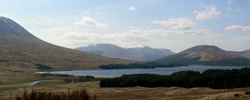
Loch Tulla
The Black Mount range is located in the Central Highlands of Scotland. It runs between Glen Orchy in the south, and between Glen Etive at the start of Glencoe in the north.
For anyone who has driven north along the A82 road, the will undoubtedly have been drawn to the plethora of peaks on show on their left after passing by Loch Tulla, especially when seen in full winter conditions. The peaks of the Black Mount continue from here in an unbroken line all the way to the start of Glencoe.
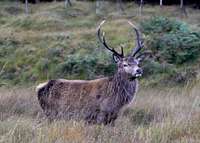
This range is the main area for red deer within the Central Highlands. Throughout the years it has always been this way and the estates have always ran deer stalking activities during the hunting season. This is no better shown, than by the name of one of the peaks; Meall a’Bhuiridh. Hill of the Roaring Stag. This must have been so named by the old Scots who’s clans worked the land here and watched the stags fighting for dominance during the mating seasons.
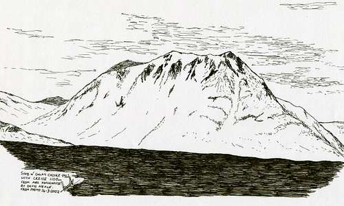
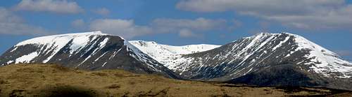 Clach Leathad & Meall a'Bhuiridh
The Black Mount range gets its name originally from the name of the forest, The Black Mount Forest. After large amounts of deforestation over the years the name of the range has become synonymous with the peaks instead. It’s a shame that it now looks so bare, I can only imagine what it must have once looked like covered in a plethora of trees that included the Scots pine which is now so sparse.
The geology of the area is mainly of Cruachan granite however, mica-schist, quartzite and gneiss are also found within the area.
The peaks of the Black Mount offer so many different opportunities for the hiker/climber throughout all the seasons. The peaks are varied and there are lots of different routes of ascent available. The most famous of these being the Clachlet traverse, an entire traverse through the range from Stob Ghabhar in the south to Sron na Criese in the north.
Getting There
CAR
Inveroran
From Glasgow take the A82 road ,via Loch Lomond, until reaching Crianlarich.
From Perth or Edinburgh take the A84 road on the outskirts of Stirling, via Callander, to Lochearnhead. Continue straight on as the road now becomes the A85 until reaching Crianlarich.
From Crianlarich, continue northbound along the A82 through Tyndrum until reaching Bridge of Orchy. Turn left directly after the Bridge of Orchy hotel onto the A8005 road. Follow this road for roughly 3 miles until reaching the Inveroran Hotel. Continue on until reaching the parking for the Victoria Bridge viewpoint at the foot of Loch Tulla.
Glencoe
Route as above however, continue straight on at Bridge of Orchy along the A82 until reaching Glencoe Ski Centre.
RAIL
From Glasgow Queen Street station take the West Highland Railway line to Bridge of Orchy. From here, you could hike towards the south of the Black Mount or hike/hitch/catch bus the remainder of the way to the Kingshouse hotel in Glencoe. Train timetables are available here
BUS
A bus service runs daily from Buchanan Street bus station in Glasgow to Fort William, via Glencoe, and then to the Isle of Skye. A full timetable is available here
Access

Snow topped Creise
There is no red tape in Scotland due to the Land Reform (Scotland) Act 2003 which incorporated the Scottish Outdoor Access Code. This code, which commenced on the 9th of February 2005, has established statutory rights of access to land and inland water for outdoor recreation.
The Land Reform(Scotland) Act 2003
Scottish Outdoor Access Code
The following aspects should be taken into consideration when you are in the Scottish countryside;
- Seek local advice in regard to deer stalking or grouse shooting activities (more details in next section)
- Ensure that all gates are closed behind you
- During the lambing season (March to May) ensure that all dogs are kept on a lead
- Please refrain from feeding or annoying any animals
- Limited parking space is available at the start of many routes, please ensure that you are not blocking a road and/or entrance
- Parking is provided at the start of some routes by the local farmers, it is polite to ask if you can use this facility
- Try to refrain from crossing fields with animals and/or crops if an alternative route is available
- Ensure that you treat the local environment with care by leaving it as you found it and by taking any litter home with you
- Any camp fires should be carefully watched and only used away from dense forest areas
- Natural waste should be done in a hole and then buried when wild camping
Deer Stalking
Deer stalking is the term used in Scotland to describe deer hunting. Due to the large numbers of deer it is necessary to cull sections of the deer during the year in order to control their over population. This activity also ensures the preservation of certain plant life within Scotland and contributes to the local economies in the areas that this takes place.
The stag stalking season runs from the 1st of July until the 20th of October. The deer hind season runs from the 21st of October until the 15th of February. The majority of estates however, have the peak times of their stalking activities between the months of August and October.
When on the hills during these times walkers can help to avoid disturbing the deer by:
1. Checking with the estate or appropriate Hillphone service.
2. Find out about stalking activities before you go.
3. On the day, follow any advice on locally posted signs about preferred routes.
4. Keep to established tracks where they exist.
5. On the hill, keep to the ridges and avoid cutting through corries especially when descending as this will disturb the deer less.
It should be noted that no deer stalking takes place on Sundays.
Information and contact numbers for planned deer stalking activities within the area can be found at Hill Phones
Deer Stalking Scotland
The Peaks

Meall a'Bhuiridh

Creise & Stob a'Ghlais Choire

Clach Leathad's east face

Stob a'Choire Odhair

Beinn Toaig

Stob Ghabhar

Rannoch Moor
Meall a’Bhuiridh
Meall a’Bhuiridh (translation: Hill of the Roaring Stag) stands at a height of 1108m/3635ft and is the highest peak within the Black Mount Range. This peak is classified as a Munro and is number 45 in the Munro heights table. The site of the first commercial ski-ing operation in Scotland has caused this peak to be badly scarred, however it is still one of the finest peaks in the range.
Creise
Criese ( pronounced Kraaysh) stands at a height of 1100m/3609ft and is number 50 in the Munro Tables. Located in the north eastern tip of the Black Mount range, Criese is the highest point of a 3km ridge that travels from Sron na Criese to Clach Leathad. The northern spur Sron na Criese is best seen from the Kingshouse hotel and this viewpoint gives an almost vertical look to it, especially when covered in snow.
Stob a‘Ghlais Choire
Stob a‘Ghlais Choire (translation: Peak of the Grey Corrie) stands at a height of 996m/3268ft and is a Munro Top. Located in the north of the range it is mostly hidden from view by Sron na Criese however, it is possible to catch a glimpse of its top from certain viewpoints.
Clach Leathad
Clach Leathad (translation: stony slope) stands at a height of 1099m/3605ft and is a Munro Top. From the east and south-east on the A82 road, its graceful curve and bulky nature are seen to best effect. The start of the ridge that runs northerly to Sron na Criese also has a connecting ridge to Meall a’Bhuiridh at point called Mam Coire Easain. This narrow ridge is prone to icing well into the spring and is not somewhere to be without crampons.
Beinn Mhic Chasgaig
A western oulier of Clach Leathad, Beinn Mhic Chasgaig (translation: MacChasgaig’s Hill) stands at a height of 864m and is a Scottish Corbett. A cone shaped peak that is located to the north west of the range, the best point of ascent is from the Alltchorunn Lodge on the Glencoe to Glen Etive road.
Stob a‘Choire Odhair
Stob a’Choire Odhair (translation: Peak of the Dun Coloured Corrie) stands at a height945m/3100ft and is number 226 in the Munro Tables. The best viewpoint for this peak is seen from Rannoch Moor, to the east, on the A82 road to Glencoe. Located to the south of the range, this peak is generally done in conjunction with Stob Ghabhar. Route page for this is here
Beinn Toaig
Beinn Toaig stands at a height of 827m and is basically a satellite peak of Stob a’Choire Odhair. This is best climbed from the south or the east and is sometimes added on at the beginning of the route around the peaks of Odhair and Ghabhar.
Stob Ghabhar
Probably the finest peak in the range, Stob Ghabhar (translation: Peak of the Goat) sits at a height of 3576ft/1090m and is listed as No.55 in the Munro tables. Stob Ghabhar's pointed summit lies at the centre of a number of ridges that provide excellent walking above deep corries. The best of these ridges is the Aonach Eagach. While not as impressive as its namesake in nearby Glencoe, this short narrow crest still involves a degree of airy scrambling. This southerly peak can be done on it’s own, but is normally done in conjunction with one or more of the peaks within the range.
Sron na Guibhas
Sron na Guibhas (Translation: Nose of the Firs) stands at a height of 974m/3195ft and is a top of Stob Ghabhar’s that is located north of its summit. Seen from the Aonach Eagach ridge on Stob Ghabhar to the south, above Corein Lochan, it is difficult to pinpoint the exact top of this short ridge.
Sron a‘Ghearrain
Sron a‘Ghearrain (Translation: Nose of the Gelding) stands at a height of 990m/3248ft and is the first of Stob Ghabhar‘s two Munro Tops. This top is located west of the summit along a small narrow ridge.
Stob a‘Bhruaich Leith
Stob a‘Bhruaich Leith (Translation: peak of the Grey Brae) stands at a height of 941m/3087ft and is the second of Stob Ghabhar’s two Munro Tops. This top is found west of the first top, Sron a‘Ghearrain.
Accommodation
There are a two areas that are best placed to base yourself for climbing in the Black Mount Range. These are;
Bridge of Orchy
There are two hotels in Bridge of Orchy.
There is the Inveroran Hotel at the foot of Loch Tulla and there is the Bridge of Orchy hotel
Wild camping is permitted next to both hotels.
There is also a bunkhouse Bridge of Orchy bunkhouse
Glencoe
There are two hotels in Glencoe. Clachaig Inn and Kings House hotel. Wild camping is permitted within the grounds of the Kingshouse hotel as long as you are well behaved.
There is also the following campsites/hostels
Glencoe Independent Hostel
Red Squirrel Campsite
Invercoe lodges and campsite
Glencoe Youth Hostel
There are also numerous B&B’s available in the nearby towns of Tyndrum, Crainlarich and Ballachullish which are all within 30 minutes drive of the area.
Books and Maps
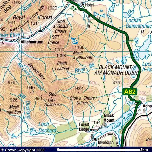
Image reproduced with kind permission of Ordnance Survey and Ordnance Survey of Northern Ireland.
Books
The Central Highlands by Peter Hodgkiss.
Scottish Hill and Mountain Names by Peter Drummond.
The Munros by Cameron McNeish.
The Munro Almanac by Cameron McNeish.
Scottish Mountains on Ski by Malcolm Slesser.
The Scottish Peaks by W. A. Poucher.
50 More Routes on Scottish Mountains by Ralph Storer.
The scenery of Scotland by A. Geike
Geology and Scenery of Scotland by J.B. Whittow
The Corbetts and other Scottish Hills by S. Johnstone, H. Brown & D.Bennet
Rock and Ice climbs: Glencoe & Glen Etive by K.V. Crockett
Maps
Harvey Superwalker map: Glencoe
OS Explorer Map sheet: 377 Loch Etive & Glen Orchy
384 Glen Coe & Glen Etive
OS Landranger Map sheet: 50 Glen Orchy & Loch Etive
41 Fort William & Glen Coe
OS 1:25 000 scale sheet 94: Glen Coe, Rannoch Moor & Crianlarich
Mountain & Weather Conditions
The weather conditions in the Black Mount can alter rapidly and you should ensure you are fully prepared for all weather eventualities. If you experience a sudden deterioration in the weather conditions and you have any doubts about continuing then please, just turn back.
Mountain forecast
Avalanche forecast
General weather forecast
Bodies of Water
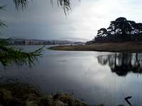
Loch Tulla
Within the Black Mount region there are numerous bodies of water. These provide areas for replenishment of fluids for all forms of life. The main lochs/rivers are as follows:
• Loch Dochard
• Loch Tulla
• Loch Etive
• River Etive
• River Ba
• Loch Ba
• Loch Laidon
Some of the minor bodies of water within the Black Mount region include:
• Corien Lochan
• Lochan an Easain
• Allt a Chaorainn
Scottish Allts (Mountain Streams) and Rivers
Scottish Lochs/Lochans
Gaelic Names Basic Glossary

Coirein Lochan

Memorial Cairn

Sron na Creise
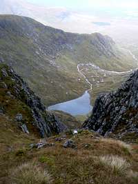
Coirein Lochan

Stob Ghabhar
Gaelic is a very rich language topographically, and this basic guide to some of the elements of place names should hopefully assist in understanding how/why the mountains on this page (and Scotland as a whole) are derived. It should be noted that in Gaelic a describing word would be placed at the end of a mountain name; i.e. Sgorr (peak) Dhearg (red), Sgorr Dhearg translated is Red Peak. This would read in English as Peak Red. For a full detail of Gaelic mountain pronunciations I recommend the following book;
• Scottish Hill and Mountain Names; by Peter Drummond.
Glossary
Allt- Mountain stream
Aonach- Ridge, moor
Ard, Aird - High place
Ba- Cattle
Ban- White, pale
Beag- Little
Bealach- Pass
Beinn(Ben)- Mountain
Beith- Birch
Buidhe- Yellow
Binnean- High, conical hill
Both- Hut
Cas- Steep
Caorach- Sheep
Carn- Heap of stones
Ceann- Head, headland
Clach- Stone
Coille- Wood, forest
Creag- Crag, rock, cliff
Cuil- Nook, recess
Damh- Stag
Dearg- Red
Dubh- Black
Eilean- Island
Eun- Bird
Fada- Long
Fionn- White, holy
Fraoch- Heather
Fuar- Cold
Fuaran- Well, spring
Gabhar- Goat
Garbh- Rough
Gearr- Short
Glas- Grey, green
Gorm- Green, blue
Guala- Shoulder of hill
Iolair- Eagle
Labhar- Loud
Lairig- Pass
Leacach- Stony slope
Leathad- Slope, brae
Liadh- Grey
Maol- Bare top
Meall- Round hill
Mheadhoin- Middle
Mor- Large
Mullach- Top, summit
Odhar- Dun coloured
Ruadh- Red, brown
Sgorr, Sgurr- Rocky peak
Sneachd- Snow
Sron- Nose, spur
Stob- Point
Uisge- Water, river
External Links
General
Visit Scotland
Discover Scotland
Undiscovered Scotland
The West Highland Way
Walk the Highlands
The Scottish Mountaineering Club
Munro Magic
Glencoe ski centre
Discover Glencoe & Loch Leven
Buachaille.com
Travel
Train timetable
Bus timetable
Inverness Airport
BAA Glasgow Airport
Glasgow Prestwick Airport
BAA Edinburgh Airport
Accommodation
Inveroran Hotel
Bridge of Orchy hotel
Clachaig Inn
Kings House hotel
Bridge of Orchy bunkhouse
Glencoe Independent Hostel
Red Squirrel Campsite
Invercoe lodges and campsite
Glencoe Youth Hostel
Deer Stalking Info
Hill Phones
Deer Stalking Scotland
Mountain & Weather Conditions
Mountain forecast
Avalanche forecast
General weather forecast