
-
 16466 Hits
-
 78.27% Score
-
 9 Votes
|
|
Mountain/Rock |
|---|---|
|
|
14.74235°N / 91.56246°W |
|
|
8202 ft / 2500 m |
|
|
Overview
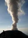
 Big explosion, ashes over 1 km high viewed from Santa Maria volcano
Considerated as the most technical and dangerous climbing of Guatemala. Santiaguito is a dacitic lava dome complex which has been growing since 1922 in the crater left by the catastrophic 1902 eruption of Santa Maria volcano, Guatemala. Activity has involved small explosions, incandescent rockfalls, emission of block lava flows and dome inflation. Pyroclastic flows generated by collapses at lava flow fronts or resulting from dome collapses have also sporadically occurred.
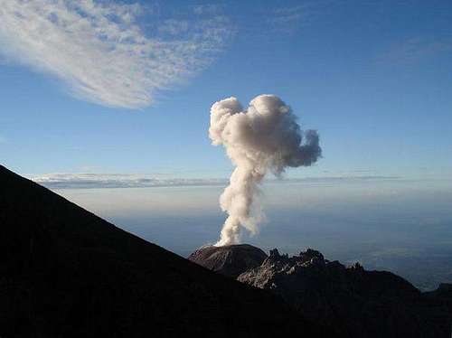
Explosions occurred very often, normally 30 or 40 explosion everyday. A major indirect impact of activity has been the frequent mobilization of loose volcanic material during the rainy season, which has resulted in numerous lahars (mudflows). These lahars have damaged infrastructure and settlements, notably El Palmar Viejo village 10km downstream of the volcano, which had to be abandoned in 1998.
One of the most bigest explotion ocurred on 25th april 2010, volcanic material was lunched over 27230 ft/8300 mts. And the most mortal explotion was on 1929, killing more that 2,500 persons. At least 10 persons died in the last years, some intoxicated, other after falldowns or hitted by rocks.
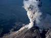
 Terrify feelings at momment we reach the summit with a big eruption at side
Getting There
The summit of Santa Maria volcano provides a birds-eye view of activity at Santiaguito. Alternatively, viewpoints exist to the North. Approach from the South is complicated by private fincas and numerous inpassable deep erosion gulleys. Climbing on El Brujo Dome is possible via a Northerly approach, but a guide is absolutely necessary to find the route. Clearly, this is dangerous and rarely offers better views than the other locations mentioned. Recently, even climbing onto the rim of active Caliente dome has been offered.
GPS reference
[img:487376:alignright:medium:]This geographical location would be very useful using a GPS, also recommended to go with an experienced guide.
Waypoint-x-y-Elevation (Meters)
Parking-14º47´12-91º32´56-2487
Check 1-14º47´04-91º32´57-2545
Check 2-14º46´49-91º33´10-2628
Check 3-14º46´40-91º33´14-2718
Check 4-14º46´30-91º33´16-2759
Sign-14º46´28-91º33´20-2798
Check 5-14º46´22-91º33´27-2817
Breakfest-14º46´12-91º33´38-2817
Breakfest cross-14º46´11-91º33´43-2843
Check 6-14º46´10-91º33´45-2840
Check 7-14º45´56-91º33´55-2802
Fence 1-14º45´56-91º33´58-2791
Check 8-14º45´50-91º34´00-2762
Crossing paths-14º45´45-91º34´03-2760
Check 9-14º45´39-91º34´01-2772
Santiaguito Viewer-14º45´35-91º34´02-2780
Check 10-14º45´33-91º34´00-2780
Check 11-14º45´30-91º33´58-2773
Cicuta Arriba-14º45´29-91º33´58-2765
Check 12-14º45´24-91º34´01-2707
Check 13-14º45´24-91º34´04-2668
Check 14-14º45´21-91º34´10-2602
Check 15-14º45´12-91º34´25-2331
Canaleta Arriba (big rocks)-14º45´10-91º34´26-2297
Canaleta Abajo-14º44´56-91º34´46-1999
Check 16-14º44´52-91º34´50-1977
Check 17-14º44´45-91º34´50-1991
Circus-14º44´33-91º34´46-2219
Camp-14º44´32-91º34´45-2225
Cost viewer-14º44´28-91º34´45-2230
El Caliente-14º44´39-91º34´13 (Never try to go this point, this final location is a GoogleEarth navigator)
Camping
Is possible to camping in a crater area "Circus". But no facilities at all. No huts, no water, be prepare with enough water and food.Some videos
Links
WikipediaPhotovolcanica
Santa Maria volcano
My own site
Baarb - Sep 16, 2008 4:53 pm - Hasn't voted
Isn't there....a river on the west side of the crater? at least there was in 2007 as we refilled some of our water bottles there on the way out....
ChristianRodriguez - Oct 31, 2008 4:03 pm - Hasn't voted
Re: Isn't there....I was there 3 times 2005, 2006, 2007 all in november, maybe in the raining season is there. I saw just tinies spots of water but filth with ashes and dust.
Baarb - Aug 13, 2009 3:22 pm - Hasn't voted
Somecrazy people on El Caliente watching eruptions up close: http://www.youtube.com/watch?v=Cy58xijSZlg&feature=PlayList&p=F5AEB6965DE5AA76
ChristianRodriguez - Aug 17, 2009 12:03 pm - Hasn't voted
HeyI know about thoses films, but... I'm not sure about if this films are for "extreme adventures" or just stupid people. hehe anyway Santiaguito is awesome
Baarb - Oct 1, 2009 2:19 am - Hasn't voted
Perhaps a route mapusing the coordinates you listed would be a nice addition?
Baarb - Oct 9, 2009 12:36 am - Hasn't voted
Also I noticed thatthe Santiaguito mountain page is currently a child of this album http://www.summitpost.org/album/402975/volcan-santa-maria.html in addition to the main Santa Maria mountain page.