Introduction
The Schober Group was always a desired destination of mine. As a teenager I made several hikes in the neighbouring mountains - in the Glockner, the Venediger and Lasörling groups, but always passed by this area. This summer I decided to take a visit.
I persuaded my former student, Peti, to come. To make the trip more desirable I promised him that we will take a detour to the Grossglockner also, if the weather allows this.
The plan was simple: using the Gernot Röhr bivouac hut as a base camp, we will try to explore as many routes as we can.
Although the forecast was very optimistic for these couple of days, the sky was usually at least partly cloudy which meant that the highest summits were almost always in clouds.
1st day
After eight hours of driving we arrived to the Ködnitz valley at 1 PM. We parked the car at the last bend of the Kalser Glocknerstrasse at 1900 m altitude. The weather was fine, but some clouds had already covered the highest peaks around. That moment we still hoped that it was only a temporary state, and later the clouds will disappear.
We started to walk up to the Peischlach saddle. Despite the long and thorough packing procedure I shortly realized that my backpack was rather heavy. Luckily the path was neither difficult nor too steep. We also had a light shower, from that kind which makes you vacillate whether it is worth to put on a raincoat or not.
By the time we arrived to the saddle I was totally exhausted. I was awake since 4 AM, I've driven more than six hundred kilometres (unfortunately Peti has no driving license), and although we made only 600 metres vertically, my shoulders were aching under the heavy backpack and my lungs protested against any further charge. The only problem was that we still had to climb another 450 metres to the bivouac. We had a short pause and vanquished the remaining part of the route in one and a half hours.
While we were preparing some dinner a thunderstorm passed by. Although no lightning strucked in the vicinity (we saw only cloud-to-cloud lightnings), the nearby lightning rod kept on buzzing even after the rain was gone.
When the buzzing finally stopped, I went out to find a nearby place with mobile network. This time it was easy: about 50 meters south of the hut I had found the perfect spot on the ridge. I sent home the daily "I'm alive, everything is OK" message, and walked back.
2nd day
The night was better than I expected. There were several blankets in the hut but we didn't need much of them in addition to our sleeping bags. As we fell asleep early, I woke up by the crack of dawn, so at 5 AM I'd already cooked the coffee.
The sky was partly cloudy but those clouds disappeared quickly and soon we were faced with perfect conditions. We decided that this was the day when we could try to reach the Grossglockner. So we had our breakfast rapidly, packed all the necessary stuff and short before six o'clock departed towards the highest point of Austria.
We had to descend back to the Peischlachtörl, where we proceeded towards Glorer Hütte, passing the mount Kasteneck from the left. This part was rather easy, without big level differences or difficult paths. From Glorer Hütte we wanted to go to the Burgwartscharte over the Leiterkees glacier (my Alpenverein map indicated a path there), but as we saw no sign of the path finally we changed our minds and walked up to the Hohenwartkees, following the route of the first climbers of the mountain.
As time passed by, a thin cloud settled to the peak of the Grossglockner. We hoped that it will be gone when we arrive there.
The Hohenwart glacier was connected to the ridge by a secured path, but it is better to say "via cordata e legnata" instead of "via ferrata" because after the first few meters we found wooden steps and thick ropes instead of the metallic hooks and cables.
The path continued as a long ascent, partly on the glacier, partly on the ridge. It wasn't very steep but we started to feel the distance in our legs. What's more, the small cloud on the peak started to grow and many more clouds accompanied it, so by the time we reached the Erzherzog-Johann-Hütte at the rock of Adlersruhe (around noon), the hut itself was already in fog.
We had a long break there and started to think what to do. The peak of the Glockner wasn't too far (we were sitting at 3450 meters), but climbing the summit ridge can be risky when it is in clouds and anyway, it would not make many sense to climb up just to see the same nothing as we were seeing at the moment in the fog.
Our first idea was that we wait there until the fog disappears, but I asked the staff of the hut about the forecast and they told that the only time when there is a chance of clear sky is the next morning. This made us to change our minds. We didn't want to wait there so long. I had already been on the summit three times before and Peti said that he will be satisfied if we walk up to 3500 meters (just to have a round number as altitude record), so we took the GPS, found this level next to a huge snowman on the ridge, and headed towards the Ködnitz valley.
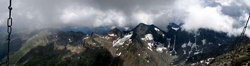
![The Mürztaler Steig]()
First we had to climb down about a hundred meters on a path secured with metallic ropes to reach the Ködnitzkees glacier. On the glacier we walked down near the left edge on the path called "Mürztaler Steig". After leaving the glacier we remained on the left side of the valley and walked along the path no. 713 to Glorer Hütte. Here we had a rest, but instead of spending the night in the hut (it was already 6 PM, so we were on the way for more than 12 hours) we decided to return to the bivouac.
So we proceeded towards Peischlachtörl and further to Kesselkeessattel on the same way we came in the morning. Finally we reached the bivouac around 8:30 PM, and noticed that we have roommates this night: a Dutch couple. They only came up to sleep here and to visit Böses Weibl, but the guy had some useful information about the area.
I didn't need any help to fall asleep this evening also. Although we couldn't reach the summit of Grossglockner, we walked around 25-30 km with a total elevation of 1800 meters.
3rd day
"This will be a rest day!" - It was the base guideline for this day's plan. So we didn't get up earlier than sunrise, and had a proper breakfast before doing anything else.
Peti had an ache in his knees so he said that he didn't want to walk to much downhill.
We decided to go down to Elberfelder Hütte and further to the Gössnitzkopf Biwak. After spending a night there we planned to cross the ridge at the Glödistörl and to return to Kesselkeessattel through Böses Weibl.
Being on a rest day we didn't hurry. It was 11 AM when we arrived to Elberfelder Hütte, and almost noon when reached the trail to Roter Knopf. Here I decided to climb up to the peak while Peti was resting his knees and having a bath in the glacier stream nearby.
The path to Roter Knopf wasn't hard. Most of it was simple walking with some easy scrambling (maybe UIAA I+) at the upper part. It took three hours to ascend and descend. I wanted to spend some time on the peak but the clouds started to menacingly grow again so I hurried back soon.
By the time I got back to Peti the some light rain started to fall and the sky above us and the mountains around were again covered by clouds. We also heard remote thunders and just hoped to reach the bivouac before we get totally soaked. Naturally the rain was faster... :)
It took about an hour to get to the Gössnitz Scharte. The path wasn't difficult althuogh at some places we couldn't call it a "path" as we only followed the marks on a field of huge stones. According to the map we were walking along the edge of a glacier but it was covered by debris in such a degree that the ice was totally invisible.
The Gössnitz Scharte itself was a wide pass (which was a surprise for me as I thought that the word Scharte is used for narrow gaps on the ridge, like the Glocknerscharte). A marked path leaded us to the bivouac which was about fifty meters higher on a naze.
The bivouac was in a very sad condition. The door was ripped off and lied a few meters away, and a PE foil substituted it, staved to the doorhole at three of its corners. All the mats and blankets (all wet, rotted and some of them a little bit "chewed") were stuffed in a huge sack before the hut, which was prepared to be carried away by helicopter (A strong sling with a heavy connector was attached to it). We searched the sack for a few usable blankets, and finally found four which had only moderate smell and were not too wet.
We discussed the scene and deduced that probably a storm ripped off the door and some rodent animals settled in the hut. The prepared sack indicated that the mats and blankets will be hopefully replaced with new ones.
We still had a lot of time before sunset so we prepared some food and tried to make the bivouac a little bit more comfortable. We placed the "stolen" blankets on the doss and put our isolier alu-mats above them. We also tried to do something with the door, but finally we only stove a nail at the fourth corner of the "door-foil" in such a way that made it possible to open or close it.
Finally, Peti leaned the door against the hole to protect the foil against the strong wind.
The following night wasn't among the best ones I can remember. The doss was hard, the wind was blowing and I hardly could wait for the dawn.
4th day
The morning come with fewer clouds. At some moments we also could glance remote peaks like the Mangart in the Julian Alps or some peaks of the Sextener Dolomiten.
We tried to figure out what the route through Glödistörl is like. I had an old Kompass map indicating it as a marked trail. The online ÖK 50 however, showed only a part of the route, from the Lesach valley till the edge of the Glödis glacier. My AV map was almost the same, but with an additional unmarked path on the southern side to Glödistörl.
I also made a photo of the saddle from Roter Knopf, and after analysing all these information we deduced that previously it was a usable route but as the glacier shrinkened, the northern side of the saddle became dangerous. (I wonder if we were right.)
Peti's knees kept on hurting so finally we decided to go back to the Gernot Röhr Biwak on the same (and the shortest) way. Later it proved to be the right choice as a few minutes after our arrival the rain started to fall again and didn't stop for a long time.
Before leaving we tried to re-mount the door of the Gössnitzkopf Biwak. We had found one of its hinges and nailed it back to its place. I am not sure it was a long lasting solution but we could not do much more.
The way back was more like an "excursion" than a "hike" as we had spent long times with trying to take photos of a marmot, washing ourselves under a waterfall etc. When we arrived back to the other bivouac, we made a three-course lunch (while it was raining outside): "curly soup" (the nickname of the Smack instant soups with plenty of curly noodles), fried sausages with toasted five-days-old rolls and Fussili Bolognese.
In the late afternoon the sky cleared a little (but not too much), and I decided to visit Böses Weibl. Peti was pessimistic, he said that I won't see anything from the top.
It took only 45 minutes to reach the top. The clouds were rapidly transforming and moving so there weren't any moments when I could see the bivouac and the peak at the same time. Böses Weibl has a twin peak. The cross stands on the northern one but the southern peak is only a few meters shorter and is really worth to visit as the panorama is different.
When I got back to the hut, Peti asked me if I had had rain because it was raining for a while at the saddle. A few minutes later it started again, and we had a lot of rain again at night.
5th day
We woke up to a nice, mild dawn. I toasted the last four rolls for breakfast. As now the conditions seemed to be more stable, Peti ran up to Böses Weibl (He is a cycle racer). He returned an hour later, and after packing all our things we started to descend back to the car. Looking back to the peak Peti felt himself lucky as again a cloud settled on it just a few minutes after he returned.
The map indicated a path which connected our saddle to the northern ridge of Böses Weibl through the Peischlachkesselkees. Although we hadn't seen any sign of this path, we tried to reproduce its track with the help of the map and the GPS. We had to cross the glacier diagonally and at last I had to use my icepick (I thought I brought it in vain as we didn't need it on the previous days). We hadn't found the path after the glacier but the terrain was not too hard so we simply walked in the direction of the ridge and finally joined in to the northern route of Böses Weibl.
From Peischlachtörl we followed the same path we were coming up on the first day and around 10 AM we arrived back to the car. Quick packing, driving down to Kals to buy some souvenirs and a loaf of fresh bread, and we started the long drive back to Hungary.
Comments
No comments posted yet.