Total Recall
Have you ever had one of those trips that you never seem to forget? Years may pass, but when you think back you can remember just about every detail from the trip with startling clarity. The type of trip that, for some reason or another, was an experience that changed you forever. I had one of those experiences when I was 24 and even though I am just now writing this trip report some 8 years later, I can remember it like it was yesterday.
Back Story - Catching Mountain Fever
![Hiking Buddies]() Hiking Buds - Ryan and Charlie
Hiking Buds - Ryan and CharlieI had never been too much of a hiker or mountain climber in my teens. Don’t get me wrong, I loved the mountains and would go snowboarding every chance I got. My local resort of Bogus Basin in Idaho offered a season pass for $200 so of course I got one and would go up 30-40 times per year. I loved being in the mountains and riding down off trail, dodging in and out of trees. I hated summer. The snow would melt, and I couldn’t go snowboarding anymore. My senior year I went on my first real backpacking trip to Alpine Lake across Redfish Lake in the Sawtooth Mountains of Idaho. I hated the hike in. The trail just kept going up, and up, and up and felt really difficult. I was relieved when we got to camp and could toss off your backpacks. That next morning I got my first taste of the beauty and majesty of mountains in the summertime. As we woke and crawled out of our tents I was sitting on a rock staring out at Alpine Lake remarking how serene it was.
![Bouldering in the White Clouds]() Charlie (right) and a friend bouldering
Charlie (right) and a friend boulderingI remember that word serene clearly because as I was thinking it my friend took the words right out of my mind and said, “I can’t believe how serene it is here.” Serene isn’t a word you hear tossed around much, and I thought it was strange that it had popped into my head to describe the moment that morning, and stranger still that my friend would be thinking the exact same thing. I was warming up to summer in the mountains.
After high school I moved away to Utah for a couple years where I did some light hiking and some dabbling in rock climbing before moving back to Idaho. After a couple years working to pay down some debt I accumulated in Utah I went back to school. I soon moved in with a buddy I had met in physics class name Charlie and I owe my love for hiking to him. He and his brother Ryan had done a decent amount of hiking and backpacking, and I had done some snowboarding with Charlie, but it was summer so he suggested we go on a hike. He took me up the trail to Sawtooth Lake in the Sawtooth Mountains and I remember walking down the trail nice and casual, chatting away when Charlie made some remark about how I should pick up the pace.
![Scoping Out Patterson]() Me and Ryan in the White Clouds
Me and Ryan in the White CloudsIt was the last time I ever walked slowly on a hike, and the last time he ever had to comment about my speed. The trip to Sawtooth Lake and Alpine Peak was amazing and is a good story for another time, but I had caught mountain fever. The next few years Charlie, Ryan, and I would spend countless weekends in the Sawtooth and White Cloud Mountains of Idaho hiking, backpacking, and bagging peaks. One set of peaks seemed to catch my eye every time I saw them from a summit: The Rakers. Jutting up in the middle of nowhere like a pair of fangs, the rakers were a beacon signing in the distance begging to be climbed. I loved the way they looked. They aren’t the biggest peaks, or the tallest, but for some reason they had an incredible amount of appeal and I just had to climb them. Most of my hikes had been planned by Charlie’s brother Ryan, but I wanted to do the Rakers so I did the research and planned the trip as a 3 nighter over my 24th birthday. We would hike up the Queens River loop and summit several peaks on the way to and the way back from the rakers. It was going to be epic.
Things Don't Always Go as Planned
As the first week of August was approaching my excitement for the trip was growing. I was super excited to visit a new area and bag lots of peaks, and excited that the first backcountry trip I had ever planned was about to happen and on my birthday nonetheless! That’s when plans started falling apart. About three days before the trip I got a call from Charlie saying that Ryan wasn’t going to be able to make it since he couldn’t get the time off. I was pretty disappointed about this. Ryan was the one guy who always pushed me in the mountains. He’s pretty much the only person I have ever hiked with who has consistently hiked faster than me. Most of the trips I had been on ended with me and Ryan basically racing up the mountain to see who would reach the summit first, with him winning 60-70% of the time. When I heard he wasn’t going I was pretty disappointed but still excited for the trip overall. Then things got worse. The day before the trip, no… the night before the trip I get a call from Charlie around 7pm saying he wasn’t going to go either. I was devastated. Both my friends had bailed on my birthday trip. I wanted to go so bad. Extremely bad. I felt like crying.
The next morning I woke up feeling pretty depressed. I went through the 7 stages of grief about my ruined trip pretty quickly. I really wanted to go but I couldn’t go alone, right? I mean, it’s not safe to go hiking in the backcountry alone much less on a three night trip, right? Plus I didn’t have any gear. I was still a backpacking noob and basically used Charlie’s and Ryan’s gear on my trips. I did have a backpack, sleeping bag, and pad, but no stove, cooking gear, or water filter. No way I could go without all that gear and Ryan was at work so I couldn’t borrow his. I wasn’t going to be able to go, right? No. F*** it, I’m going to make this happen. I called my dad who was a former backpacker in the 70’s and 80’s and asked if he had any gear to borrow. He did! It was well after noon at this point, but I packed up my stuff and headed over to my dad’s house to pick up the stove and water filter. The stove was an old school 70’s white gas stove that my dad had to spend 10 minutes showing me how to use, and the water filter was the most pathetic thing I’ve seen. It basically looked like the pump from an industrial sized tub of mayo attached to a rough filter that my dad said would really only filter out giardia. It was perfect.
The Journey Begins
I made it to the Queens River trailhead around 5:30 and parked in an empty parking lot. As I threw my pack on, I made eye contact with two men guiding a couple of horses across the field and made my way towards the Queens River trail. These would be the last people I would see on my trip. I hiked up the Queens River trail for a couple hours until it darkness started closing. Shortly after a river crossing near Nanny Creek I decided to set up camp right off the main trail in a flat basin. As dusk began to fade I made a freeze dried meal, set up my tent, and checked in for the night. I was feeling pretty good about the trip, but still missed the company of my hiking buds.
My 24th Birthday - Plummer Peak Summit
![Mount Everly]() Mount Everly
Mount Everly
The next morning I woke to some noise around my tent. I quietly poked my head out the window of the tent to see what was making noise around my tent. A short distance away I spotted a deer who had made her way through my camp. I followed her until she passed around the side of my tent. I unzipped my door to get a better view, but the noise scared her away. I wished I had mesh windows in the doors of my Mountain Hardware Hammerhead 2 like the newer models do, but it was a good way to start my birthday. I ate some oatmeal for breakfast and packed up my gear had hit the trail for the day. I’m not sure what it was but I felt terrible, no energy at all. As I was hiking up the trail my legs felt heavy and sore, not exactly what I was used to since I was in pretty good shape. As I made my way up around the west ridge of Mount Everly I stopped to hide my pack in the bushes near the junction with the trail heading towards Benedict Creek. I swapped my hiking boots out with my approach shoes, a $40 pair of Adidas running shoes that I discovered had particularly good grip on rock, and threw on my day pack. With a fresh pair of footwear and my shoulders relaxing after being freed of the burden of my backpack, I made my way towards Plummer Peak.
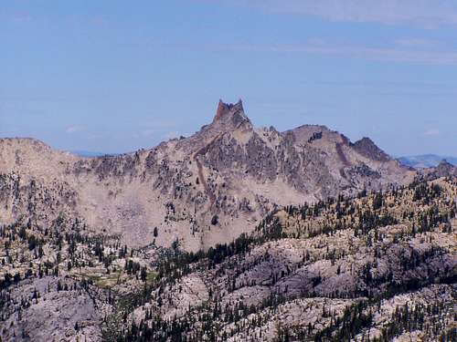
![Raker Mountains]() The Rakers from Plummer
The Rakers from PlummerRounding the northwest face of Mount Everly the view of Everly was quite impressive. I bounded off across a meadow for a couple hundred yards to get far enough away from the mountain that the entire peak would fit into a picture. After snapping a photo, I continued on around Everly and made my way up to Everly Lake where I would get my first good view of Plummer Peak. After scouting a route for a few minutes, I continued on down to Plummer Lake and made my way toward the peak. I had my eye on the granite section that made its way most of the way up to the summit ridge as my route. The rock was great. For the most part I was able to smear for enough grip to basically walk up the granite with only occasional use of hands. It was a fun little section to scramble. Part way up I looked back and to the left and BAM! I got my first view of the Rakers, my primary objective. Once on top of the granite, the going was a little slower as I made my way up the scree to the summit. It was rewarding, and the scrambling section seemed to invigorate me a little, but I still wasn’t feeling all that well. The down climb was relatively uneventful and I made it back to where I had left my pack. My plan was to camp at one of the lakes at the top of the Queens River loop, so I grabbed my pack and started up the trail.
![Plummer Peak]() Plummer Peak en route Plummer Peak en route | ![Mount Everly and Plummer Lake]() Mount Everly from Plummer Peak Mount Everly from Plummer Peak |
![Raker Mountains (from SE)]() The Rakers from Plummer Peak
The Rakers from Plummer Peak
My legs were not happy with me having to gain elevation up the trail with a heavy pack on. This part of the trail really isn’t that hard, gaining around 500 feet of elevation in less than one mile, but it sure felt that way to me. I finally made it up to what I thought was Arrowhead Lake, a beautiful basin surrounded by rocky slopes on one side, and a nice view of Mount Everly on the other side. I had actually reached Lake 8696 on the other side of the pass just before Arrowhead Lake, but it didn’t matter to me. I was in heaven. I found a good spot to camp, set up my tent, and laid down to listen to some music. It didn’t take long for a little rest to turn into a nap. I slept maybe an hour or so and woke up quite thirsty. I grabbed my mayo jug pump of a water filter and headed to a stream to filter some water. On my way to the stream I began to reflect on my situation and how it was my birthday and I was happy to be in the mountains, yet a little sad to be out here alone. I began to pump some water, lost in my thoughts and feeling a little lonely when my eyes came to focus on a hole maybe five feet away across the stream with a small frog in it staring back at me. A couple butterflies danced around the stream stopping on a rock for a few seconds before taking flight only to stop on another rock a few seconds later. I may have been the only human with miles, but I was not alone. I didn’t feel much like doing anything else, so I squandered the last four or five hours of daylight hanging around camp and napping. I went to bed early before the sun had set, eager to get some much needed rest and prepare myself for the Rakers the next day.
![Lake 8696]() Lake 8696 Lake 8696 | ![Mount Everly from Lake 8696]() Mount Everly from Lake 8696 Mount Everly from Lake 8696 |
Summit Day - The South Raker
![Arrowhead and Pats Lakes]() Arrowhead and Pats Lakes
Arrowhead and Pats LakesI woke up the next morning to sunrise, feeling WAY better and a year older. Well, I didn’t actually feel older but the first day of my 24th year of life was bound to be a good one as this was the day I would reach my goal of climbing the South Raker. I ate three packets of Quaker raisins and spice oatmeal for breakfast, packed up my gear, and headed up the trail. The trail up to the pass was steep, but my legs were up for it. After the short but strenuous hike up to the pass a lake came into view. Wondering what I was looking at, I pulled out my topo map to have a look. It was then I realized that I was looking at Arrowhead Lake and had actually camped at Lake 8696 the night before. After seeing Arrowhead Lake, I’m glad I stopped at Lake 8696 as the camping available there was worlds better.
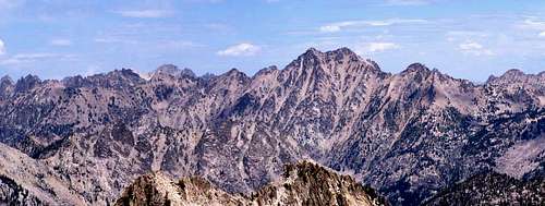
I left the trail at this point and headed up to the knob south east of Blacknose Peak. I dumped my back here and left a note on it stating who I was, where I was going, and when I expected to be back in case someone came across it. I could see the Rakers and was eager to reach the summit of the South Raker, but my first objective of the day was to summit Blacknose. I began heading up the south east ridge of Blacknose peak and it didn’t take long before I reached some difficult terrain. I scrambled up some rocks and quickly ran into a large cliff face blocking the direct south east ridge.
![Blacknose Mountain]() Blacknose Mountain
Blacknose MountainAt this point I had a couple options. I could have gone left and tried to skirt around the cliff face but that would have involved some downclimbing and a traverse across some steep dirt/scree. I didn’t like that idea and decided to abandon my summit bid for Blacknose and just head straight to the Rakers. From where I was at my other option to the right was to downclimb a steep gully on the north east face of Blacknose. In hindsight, the route around the cliffs was probably the better option compared to what I was about to face next.
The gully was steep class 3 possibly class 4. You can see the gully on the picture of Blacknose, just below the notch left of the summit. The first half went smoothly as the terrain was solid rock and I was able to downclimb facing out with ease. About halfway down things got a little sketchy. The gully steepened and became very sharp with crumbling and loose rock on one side, steep near vertical on the other, and filled with loose dirt in the center. It was all I could do to keep my footing at this point. Each foot placement was critical as I slowly lowered my weight onto each foothold, making sure that the dirt and loose rock under my foot wasn’t going to give way. Core muscles engaged I made it down the last 15-20 moves of terrible footing section and into a gigantic boulder field below. Being on boulders was a huge relief. The footing was much more reliable and I worked my way down and around the boulders maintaining a fine balance of trying not to lose too much elevation while trying to avoid steep side hilling. After reaching the base of the next ridge I ate a power gel packet and began the final push to the South Raker.
![Island Lake near The Rakers]() "Island Lake"
"Island Lake"The push to the ridge was mildly annoying steep uphill on soft dirt with some occasional scree and rock that really got the legs going. After about 800 vertical feet of this I reached the ridge that would connect me to the Rakers. The views were stunning! Blacknose peak looked very impressive from this angle, as did the Rakers. I was surprised how many lakes there are in the area around the Rakers. I pushed on and summited the 9722 and then over to the point listed as “South Raker” on the USGS Everly Quad. This may be the official “South Raker” in some sense since it’s listed that way on a map, but climbers have always referred to the Rakers as the dual summits to the north calling the North summit the North Raker and the south summit as the South Raker which was my goal. As I began to make my way up to the saddle between the Rakers, the terrain changed from loose dirt and scree to talus and boulders. A short section of talus/boulders put me at the saddle between the Rakers, a marvelous place to be!
![Raker Summit View]() View from the saddle between the Rakers
View from the saddle between the Rakers![South Raker]() Final summit block of the South Raker showing 2 steps requiring mantling
Final summit block of the South Raker showing 2 steps requiring mantlingWith my final goal in sight I began the scramble up to the summit of the South Raker. The first few moves were easy class 3 but as I worked my way up things got interesting. The route narrows to where you have about 5 feet on both sides of you with serious exposure to the left and right, particularly to the left. About 50 feet below the summit I ran into a smooth rock wall about 5 feet high with a narrow ledge above the wall. I could reach the ledge easily with my hands, but I had nowhere to put my feet! I looked all around but could not find any foot holds to reach the next move. Not willing to be deterred I figured I could just jump up a little and get my hands under me and support my weight on my extended hands then lift a foot up to the ledge where my hands were, similar to what you would do to get out of a swimming pool without a ladder. I had never done a move like this in the mountains, much less with hundreds of feet of exposure on both sides! I learned after the fact that this move is called mantling and it worked. Just below the summit there was another short rock wall about 3 feet high that posed some similar difficulty and shortly after that, the summit!
The summit of the South Raker was pretty trippy. The summit is about the size of a large coffee table with several hundred feet of exposure on all sides. The views were like being in an airplane. To make things more interesting, the wind was putting on quite a show for me. As I sat there I watched the wind blow patterns of ripples across the many lakes surrounding the Rakers. The ripples would start on one side of the lake and quickly roll across the water to the other side. On a couple of occasions I witnessed two different sets of wind ripples come from opposite sides of the lake only to crash against each other in the middle. It was an enchanting phenomenon I have not seen repeated on any other summit since. After some time enjoying the views and snapping a few photos I set off back down to the saddle.
![South Raker Summit View]() Airy summit view - lake with wind ripples
Airy summit view - lake with wind ripples
I probably spent 20 minutes looking all around for a summit register with no luck. I looked everywhere but it was nowhere to be found. I went up to the North Raker and took a look at the route. It looked like the first few moves could be accomplished with some class 5 climbing before the final summit block is reached which is smooth featureless near vertical rock, class A2. Satisfied with reaching my goal and still buzzing from my experience on the summit I began the long trek back. I made my way along the ridge system and back down to the boulder field below Blacknose Peak. This time, I made my way around Blacknose to the east and found a nice long sloping granite ramp back up to the saddle. My pack was right where I had left it (no surprise) and I decided to keep my scrambling shoes as I hiked to the next camp.
Mission Accomplished
I made my way past Arrowhead and Pat’s Lakes and couldn’t help but reflect on how good it felt to do what I just did, hike a class 4 summit in the middle of nowhere by myself with no person within 5-10 miles. It was pretty wild. But it felt like it was over. As I reached the trail junction to Brown’s Lake, my next camp destination, I wasn't too excited about the hike up to the lake. It was going to require more elevation gain with a heavy pack on. When I got there I was going to have to sleep in a tent by myself in the cold and for what? To climb a couple more peaks only half as cool as the Rakers? Not being thrilled with the prospect of enduring another night in the mountains by myself after already completing my goal I decided to skip my last night in the mountains and head home. I figured I had just enough daylight to make it the rest of the way back to the car so off I went. The rest of the hike back was one of those long hikes with sore feet where you expect the trailhead to be “just around the next corner” about 15 times before you actually get there. I had to cross the Little Queens River on foot with no bridge which left my feet wet for the last hour or two back. Finally, my car came into sight just as the sun was starting to duck below the horizon. I had made it. The drive back was mostly in the dark and I had to play chicken with 20 or so deer on the long dirt road before I reached the highway and made my way home.
Moving on from the South Raker
My experience climbing the South Raker solo as my first trip alone in the mountains really meant a lot to me. Shortly after the trip I adopted the name “SouthRaker” when I signed up for an online poker site. I figured you want to rake the chips in your direction (south I suppose if viewing the poker table as a compass) so I thought SouthRaker was a fitting name. I also started doing a lot more trips by myself. About two months after the trip I moved on to graduate school in Portland and it became difficult to find hiking and scrambling partners who shared my passion for the mountains. Fortunately I wasn’t hesitant to go by myself any longer and wouldn’t have to let other’s desire to be in the mountains affect my desire and ability to go on trips and enjoy time in the mountains. In fact I’d say well over half of my trips from that point forward have been solo trips. In 2006 I joined SummitPost and it seemed fitting to use the name SouthRaker. The name just fit me, and I enjoyed using it for several years.
Recently I decided to give the mountain its name back and take on my own identity. I’ve pretty much given up the SouthRaker name everywhere except for its original use on Pokerstars. I am grateful for the South Raker and its contributions to my life, but it is time to move on. There is a saying that memories fade, but the heart never forgets. God forbid I lose my memory any time soon, but I know for sure that my experience with the South Raker will carry on in my heart as long as I live.
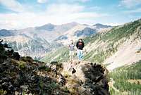
![Summit Leap!]() awilsondc - Gray Wolf Ridge solo summit shot
awilsondc - Gray Wolf Ridge solo summit shot
Comments
No comments posted yet.


 Plummer Peak en route
 Mount Everly from Plummer Peak
 Lake 8696
 Mount Everly from Lake 8696