
-
 6239 Hits
-
 74.01% Score
-
 4 Votes
|
|
Route |
|---|---|
|
|
49.75650°N / 125.52944°W |
|
|
Hiking, Mountaineering |
|
|
Spring, Summer, Fall |
|
|
Class 3 |
|
|
Overview
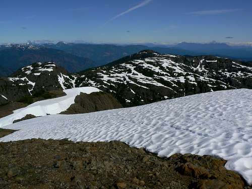 Mt Adrian North Route: looking north from the summit Mt Adrian North Route: looking north from the summit |
Reaches Rodger’s Ridge from any of the convenient high roads below and follows the ridge south, over or around Mt Beadnell, the high point on the ridge, to the foot of a high point west of Mt Adrian.
Travels over the high point and then swings east to the foot of Adrian itself. Follows the ridge up to the summit staying on the right (south) to avoid steep ground.
Mt Adrian North Route: looking south towards the summit
Getting There
Sihum Creek/Rodger’s Ridge ApproachFrom Campbell River at the end of the freeway section of Highway 19 take highway 28 west towards Gold River. Drive for 17 km from the silver bridge at the junction of highways 19 and 28 and find the Quinsam Mine road on the left.
After 3.3 km bear right and leave the road to the mine on Argonaut Main.
Drive a further 16 km southwest past Quinsam Lake to the junction of Argonaut Main with Granite Main and turn left. The onward route is straightforward and the most travelled road is the one to follow at any junctions.
Drive south up the Sihun Creek valley on Granite Main to whichever of the access points to Rodger’s Ridge is your choice. Access from the north from the vicinity of the small unnamed lake at about N49 48.177 W125 32.974 is very convenient via cut snowmobilers trail to the col between Rodger’s Ridge and Lupin Mountain.
Or you can travel directly up to and over Mt Beadnell, the high point of Rodger’s Ridge from Beadnell Lake. From the Argonaut/Granite junction directions for both are as follows:
-At N49 51.025 W125 32.881 keep left
-At N49 49.545 W125 31.867 bear left
-At N49 48.584 W125 32.243 at a prominent junction keep right for the small lake and the north part of Rodger’s Ridge or left to get as close as you can to Beadnell Lake
-If travelling to Beadnell Lake drive 1.2 km and turn right up a rough spur at N49 48.311 W125 31.748. 4WD may be necessary from this point. I’m not aware of a trailhead but this road does approach to within 200 metres of the lake shore. Try starting from N49 48.111 W125 31.779, about 300 metres up the spur.
-If travelling via the small lake proceed 2 km from the junction to N49 48.150 W125 33.257 and find a spur on the left. Drive up the spur 150 metres to N49 48.095 W125 33.343 and find an obvious use path and a flat spot for one or two vehicles to park.
Route Description
Although Mt Adrian can be approached from the north via Beadnell Lake, this description will concentrate on the well travelled route to Rodger’s Ridge from the unnamed small lake under the south aspect of Lupin Mountain. Refer to the approach directions above for details.Start from the well used and obvious trailhead at to N49 48.095 W125 33.343 the end of the short spur off the right branch of upper Granite Main.
 Rodger's Ridge TH Rodger's Ridge TH |  Snowmobilers' track Snowmobilers' track |  Lower Rodger's Ridge Lower Rodger's Ridge |
Follow the use path west through the old logging slash and enter the forest above. You will immediately come across the red markers placed by snowmobilers high on trees and VERY obvious signs of their passage in the form of a wide swath of cut trees and bushes. Head south up the path to a lovely series of sub alpine meadows and tarns in no more than 10 minutes from where you entered the trees.
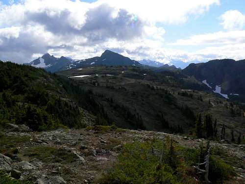
From the area of tarns you can see the crest of Rodger’s Ridge above you to the south. Either head directly up or traverse off to the southwest towards a low point on the ridge following flagging and the occasional boot path. Aim for the neighborhood of N49 47.478 W125 33.673 where you will find another open tarn filled area. The route up Lupin Mountain also starts from this vicinity.
Continue up but swing round now to the southeast. After 500-600 metres on this new heading you will emerge from the last big trees and out onto an alpine bench below and to the west of the crest of Rodger’s Ridge. In this vicinity also, keep your eyes open for the snowmobilers’ “Rodger’s Ridge Cabin” in the trees under the ridge.
 Rodger's Ridge cabin Rodger's Ridge cabin |  Upper Rodger's Ridge I Upper Rodger's Ridge I |  Upper Rodger's Ridge II Upper Rodger's Ridge II |
I’m not too sure of the legal status of this well founded structure or if the land owners even know about it. Whatever the case, it’s well set up with a wood stove, tables and chairs and emergency food and medical supplies. And whatever else I think about the dubiousness of the whole business of motorized activities in what should be a pristine alpine setting, you have to give these guys credit for leaving the cabin unlocked for all to use – especially should an emergency arise.
Continuing southeast from the cabin site, the route crosses a shoulder – from which a quick detour to the east to visit Mt Beadnell is possible – and then drops down to a very open slabby area to the south.
Cross the slabs, continue south and surmount a step in the ridge on the left (east).
Continue south for 800-900 metres with a few ups and downs before the ridge swings to the east and drops down to a saddle at the foot of Mt Adrian’s west ridge. A bench on the right of the ridge crest avoids steep cliffs to the northeast and offers a friendly route to the summit from about midway above the saddle.
Route summary from the snowmobilers' TH and return:
Distance: ~ 14 km
Net elevation gain: ~ 670 metres
Total elevation gain: ~ 900 metres
Approximate time: ~ 8-10 hours return
As always a Garmin/Mapsource tracklog is available for the north approach and route on Mt Adrian. As a general rule I don't make routes universally available as GPX files but just ask for it via an email or PM..
Essential Gear
Although a few minor scrambles are involved, this is mainly Class 2 hiking requiring nothing out of the ordinary in the way of grear.Camping, Weather, Links, Red Tape, Safety etc
Please refer to the parent mountain page.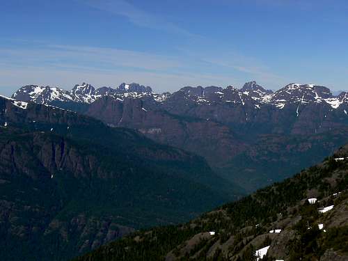
Mt Adrian summit view northwest