
|
|
Route |
|---|---|
|
|
39.02130°N / 119.474°W |
|
|
Hiking |
|
|
Spring, Fall, Winter |
|
|
Most of a day |
|
|
Overview
The North Ridge of Mt. Como is a straight-forward day hike, easily reachable from northern Nevada communities like Carson City, Reno, Minden, Gardnerville, etc.While slightly longer than the shortest route described on the main page, this route can be accessible for 2WD vehicles in dry conditions (although 4WD and/or high clearance is highly recommended).
For 2WD, the summit is reached in about 5 miles from an obvious parking area. A Jeep road heads directly to the summit, albeit fades out about 1 1/2 miles from the summit. But no worries. It is very easy to follow from there.
The advantage of this route is the spectacular views. The ridge is reached after only 2 miles. So there is plenty of time to enjoy wide open views of the surrounding landscape. Further, there are plenty of sub-peaks along the ridge that offer additional mileage for the hard-core hiker.
Getting There
Follow the directions on the main page up to Sunrise Pass Road, accessed off of Johnson Lane. As stated on the main page, you will pass Mineral Peak and take the turn off Sunrise Pass Road. This is the first right after Sunrise Pass Road begins to descend on the north side of Mineral Peak.Follow this road for about 2 1/2 miles. The road isn't terrible, except in muddy conditions. Stay on the road that looks like the main road. Avoid off-shoots. The road is at 39.0515, -119.5145.
If you have a solid high clearance 4WD vehicle and conditions are dry, you can probably make it all the way up to the ridge and within a couple miles of Mount Como.
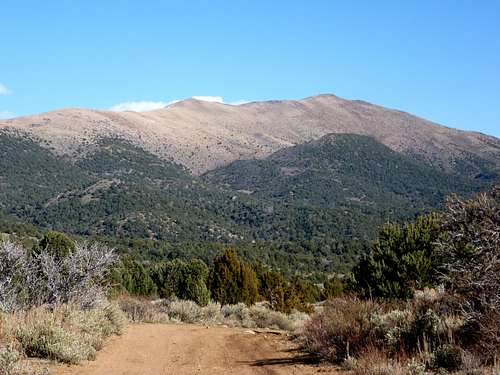
Mt. Como seen from a little less than a mile from the start of the road to the North Ridge.
Route Description
Follow the road east towards the peak. The road heads up the slope, trending northeast and eventually cutting back to the south. Trust the main road you are on. It will lead you where you want to go. You will reach the tree line after about 2 miles.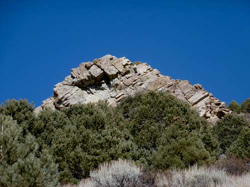
If heading the correct route, you pass this rock formation on your left near tree line
Once you come out of the woods into an open area, there is a Y junction. The right fork is the more direct if heading to Mount Como. It descends a little over 100' before heading back up and over one of the small sub-summits along the north ridge. Continue on the road (there are no viable short-cuts) until it ends. A trail/path cuts to the left of a hillside, eventually ending at the base of the climb up to Mount Como.
It is about 1 1/2 miles and 1,000' to the summit from here. There are a couple false summits along the way. The first you expect. You pass it and see what appears to be the true summit just ahead. But it's not. You still have another 10 minutes or so to go.
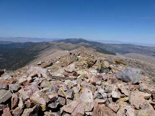
Summit view looking north back down the north ridge route
Total Round Trip hiking distance is 10 miles with an elevation gain of about 2600'. If wanting extra distance, Peak 8305 (with 309' of prominence) can be reached by heading east on the north end of the ridge. If you were to take the left fork on the Y-junction mentioned earlier, you see it to the east. It adds 1 1/2 miles to the hike.
When to climb
The best time of year to hike Mount Como is probably late fall (October/November). That part of the year is usually pretty dry. Winter can be a problem if it is wet. Summers are way too hot to attempt Mt. Como. Springtime is great, as long as conditions are reasonably dry.Do not attempt Mount Como after a rain storm, or right after a major snowmelt. You will not make the trailhead. These roads are notorious for muddy conditions.
If it rains the day before you plan to go, then don't go!
Wait a few days, or wait until the following weekend. The road dries quickly, so a couple days after a rain and/or snowstorm, it should dry up, especially if weather is in the 50s or higher. Usually there aren't big rain or snow storms here outside of winter. If hiking after a major storm, however, wait longer. The North Ridge route is on the sunny side of Mount Como, so snow accumulation is far less than on the east side (which is far less accessible anyway).