Mount Ouray
From Marshall Pass
Sunday Sept 23, 2012
I’d wanted to enjoy the Colorado high country during the peak autumn leaves season for a few days. My wife Maggie had gone to Florida to spend time with her family and I was pleased to see that the weather was in a most favorable period per the NOAA web page through the weekend and into the early part of the following week here in Colorado and also in Florida. I wanted to get away and do some camping and fishing as well and checked the ReserveAmerica web page to find that O’Haver Lake was now open from September into October. I packed my truck with all my camping gear and hit the road early Saturday as I wanted to give myself the best possible chance to get a decent campsite as it was first come first served only, no reservations taken.
Traffic was light and my drive down route 285 through South Park went well with the aspen in their splendid glory over Kenosha Pass and beyond; I’d picked the right weekend. The Collegiate Peaks through Buena Vista all had a dusting of snow on their upper most portions but below I was enjoying a sunny 72°. I continued down to route 50 and through Poncha Springs and up towards Poncha Pass to the right turn for O’Haver Lake. I was happy to find a few open sites and chose one with plenty of space for my rather large tent. I’d camped the weekend before with my son Collin at Lake Granby and next weekend Maggie and I were heading for New Castle to camp with friends; thus I’d be camping for three straight weekends. Awesome!!
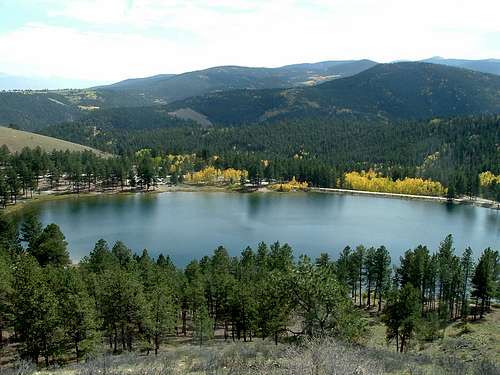
O’Haver Lake had just gone through a facelift by the US Forest Service and all looked really great;
![O Haver Lake]() O'Haver Lake
O'Haver Lake
new tent pads, fire rings and picnic tables. The price per night was now $17 which shows how they want a quick ROI but I didn’t have a problem with any of this until I met the camp host. I was told that if I didn’t have my camp pitched and paid inside of 30 minutes I was subject to “removal”. I’d used my hatchet to plant my tent stakes and soon found that I was subject to a $250 fine for having a hatchet in my campsite!! I pleaded with the host to show some leniency which he did as he filled me in on all the many rule changes. No chopping firewood within the campground, no firewood exceeding 28” in length. I’ve been camping in federal and state campgrounds over the last 50 years and never heard of such regulations; I made every effort to now befriend my camp host in fear of him imposing further jurisdiction over my stay.
I rigged a bubble-and-fly rig for fishing and was treated to some excellent trout fishing as I caught and released some nice fish while circum-navigating this beautiful little lake at 9200’ with the awesome views of autumn in all directions. I saw one poor soul splitting wood in his campsite and cringed at the though of the camp host coming down hard on these people. Mt Ouray stands tall up towards the west and can be seen from the south easterly side of the lake complete with the contrasting gold/yellow/orange of the aspen against the evergreens; really spectacular!
![Mt Ouray from O Haver Lake]() Mt Ouray from O'Haver Lake
Mt Ouray from O'Haver Lake
The sun was setting quickly through broken clouds as I completed my fishing and headed back to camp for a nice meal next to a blazing fire.
Darkness came quickly and before long I had a nice blaze going in my woodstove inside my tent to break the increasing chill. After making certain my campfire was dead out I loaded-up the woodstove and was into my sleeping bag about 8:40pm; I was pretty pooped and soon fast asleep. In the black of night I was awaken by headlights shining on my tent as I could hear a vehicle driving back-and-forth no less than 5 times. I looked at my watch and its 2:30am, the first thought through my sleepy head is; “that friggen camp host!”. I crawled outside and saw his truck drive back-and-forth three more times; “what the frick!” so much for all quiet after 10:00pm! This bozo finally settled back to his campsite about 30 mins later as I lay awake wondering what in the world he was up to now.
I awoke a bit groggy not having slept to great and was startled to see that it was already 7:00am with perfect but quite cool (mid 30’s) weather conditions and the sun rising quickly. I wasted little time and had myself on the dirt road up to Marshall Pass in a matter of minutes.
![Autumn Aspen]() Marshall Pass Road
Marshall Pass Road
My breakfast would now consist of a quart of Gatorade while driving up the 9+ miles to the trailhead at Marshall Pass. I didn’t see any other cars all the way and parked at the squalid outhouse which served its purpose and then up the Colorado Trail heading due north right at 7:41am with Mt Ouray clearly visible to the northeast. This trail is pretty much a road for the first mile or so and I soon realized that I could have driven well up to where the foot trail actually begins; oh well. Although I’d done my homework before heading up here I was a bit uncertain of where this trail was taking me as it seemed a bit too far west from Mt Ouray.
Sunny/clear skies and a good trail had me well into the deep forest as I was nearing the 1 hour mark and still hadn’t seen any clue as to where the trail might branch-off for Mt Ouray. I told myself I’d keep hiking until 9:00am and if I hadn’t found the way by then I’d turn back in defeat. I found a full ½ liter Camelbak bottle of orange drink laying right on the trail and pack it away for future consideration as in my haste to get going this morning I had zero food but did grab a tin of wintergreen Altoids from my truck. As I neared 9:00am the trail broke free from the trees and there I took the Little Cochetopa Creek Trail to the right now heading due east and made way much higher up above tree line following a worn trail with wooden posts as markers until I reached a high saddle. Now finally, directly across a vast basin stood Mt Ouray the first I’d seen it since leaving the trailhead.
I paused for a good rest and plotted my next course. I was situated on a long connecting ridgeline that went a full 180° semi-circle around right and up to the summit of Mt Ouray complete with rocky/grassy, ups & downs, with a “sawtooth” appearance from where I stood at about the halfway/90° mark. Here the winds started a bit from the west and cooled things down rather abruptly as I began this not-so-difficult ridge hike and made good progress along a goat trail of sorts and could now see well below where my truck was parked and saw that I was still the only vehicle parked at the trailhead. I continued on and now came to where another ridgeline broke to the right while I kept left and thought that maybe that would be my descent route later.
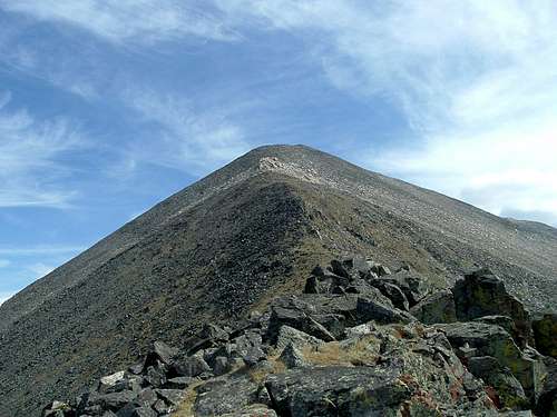
I still had plenty of work ahead of me and although the hike was going well I was now heading through and beyond the “sawtooth” I’d seen earlier and was now going up Mt Ouray proper with a large/white outcropping of rock up ahead.
![Mt Ouray from the Uppermost Connecting Ridge]() Mt Ouray
Mt Ouray
Staying either directly on the ridge or just left of it seemed liked the best advance and I saw an occasional footprint from previous visitors telling me that I was where I should be. My standard hike some and pause often yet briefly was serving me well as I reached the white/rocky section and stayed left here through some rugged sections before gaining the ridge again and with every step being an upward one I pressed-on. From below it seemed as though the white/rocky section was just before the summit, yet here on the ridge I found that to be a farce as I now seemed to be chasing a summit that somehow just wasn’t there. An endless climb to a topless mountain it seemed as I stopped to catch my breath and spoke aloud to the Lord above to bring me to my destination sometime soon.
I now crossed-over some flat/silver slabs and then back into more rugged talus while keeping my eyes down and watching every step until I now saw ahead a wooden log sticking up from a pile of stones and clambered up and onto an empty summit at 10:52. I’d finally made it! I stepped up onto the rocky pile and touched the tippity-top of the wooden post to claim the true high point then found a flat spot to remove my pack and gain some protection from the cool breeze that now chilled my perspiration. I saw two separate stone bunkers that others had made which told me that the winds up here could be far stronger than the ones I was experiencing. I made my customary cell phone call to Maggie and left her a message before then taking pictures of the many sights from this high pinnacle.
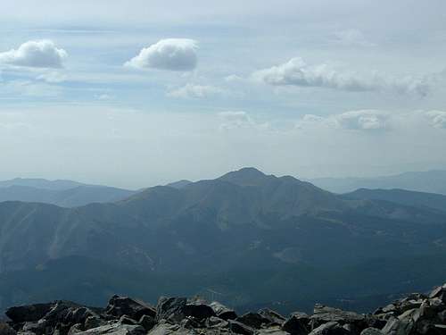
![Antora Peak]() Antora Peak
Antora Peak
I then ventured to the windward side and found the summit registry to sign and then settled-in to relaxed for a good rest as I was feeling a bit “bushed” at this point.
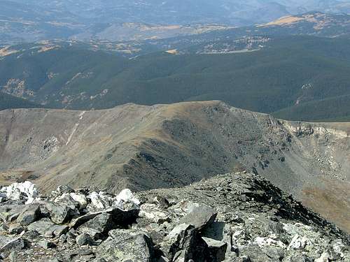
![Collegiate Peaks]() Collegiate Peaks
Collegiate Peaks
Digging through my pack I came up with three aspirin and the Camelbak bottle I’d found earlier and consumed both on the spot in about 20 seconds flat; the orange drink was a power drink of some kind and I was glad to have it. I also sucked on a couple of Altoids and put a few in my pocket for the way down and started back down at 11:14.
![Mt Ouray Summit Shot]() Summit Shot
Summit Shot
I wouldn’t stop for another rest until clearing the “sawtooth” section and paused for a good photo shot of Mt Ouray. I then gained a good breather and soon found the goat path and proceeded to where the other ridgeline went left; here I met two guys coming towards me from that ridge.
![Mt Ouray connecting Ridgelines]() Connecting Ridgelines
Connecting Ridgelines
They were Pete and John and I asked about the way they’d come and they assured me that I could save a lot of steps and time by taking this ridge across and then descending via a “bushwack” through the trees and back to the trailhead at Marshall Pass visible below. A fortuitous meeting as I otherwise would have gone back the way I’d come up adding to my efforts and fatigue. Nice!
Now I had a new vigor in my step and made quick work of the ridgeline before coming to a large cairn where I took a visible heading toward a distant high point directly in the direction I wanted to go. Plodding back down and into the trees went well and making my way back through the shade of the forest brought needed relief from the sun and the constant breeze. I would see two large doe mule deer while making my way back through this heavy pine forest where many trees had been uprooted by what must have been heavy winds. My dead reckoning, visible, high point navigation brought me right where I wanted to be and I was relieved to now see the trailhead parking lot as I busted through one last bushy section, onto the dirt road and back to my truck right at 1:12pm.
![Mt Ouray from The Marshall Pass TH]() Mt Ouray from The Marshall Pass TH
Mt Ouray from The Marshall Pass TH
Another centennial 13’er on this gorgeous autumn day in the Sawatch Range of Colorado………..Sweet!
Back at camp for one more night where I spoke to the camp host about the goings-on the night before. Turns-out he was searching for some supposed teenagers that had shined a light into a campers trailer as a prank (oh, boo-hoo). He radioed the sheriff who soon arrived and how they ever dreamed that they’d catch them by driving back-and-forth with his headlights on for 40 minutes I’ll never know. Takes all kinds I guess; what a couple of maroons.
As luck would have it (and the Lord above); my timing was good as that night a cold front would come through and cover the high country with rain & snow over the next couple of days……..More good fortune.


Comments
Post a Comment