Intro
I just moved to the Seattle area last year (2006). I would eventually like to be able to climb the high volcanoes but I'm not naturally in good enough shape now. In the mean time I've been looking for day hikes with a lot of elevation gain. Naturally I found Mt Pugh on the internet and scoped it out on my topo software.
I didn't want to risk climbing 5000 ft up and not getting any good pictures, so I waited most of the summer for a decently clear weekend. I finally got psyched when I first saw the weather forecast for the weekend of the 8th and 9th of September. There was my chance. I couldn't find a hiking partner as everyone I knew had other plans :(. Oh well, with the way things have been this summer I figured it was now or never so I decided to go on a solo hike.
Getting There
![Lake Metan]() Lake Metan
Lake Metan
Unfortunately I didn't get to sleep until 2:30 AM the night before. Wanted to get out of bed at 5:30 but couldn't get moving until 6:30. Had a quick breakfast, did some last minute packing, and left the house around 7:15.
I would have been on the trail at 9:30 had the stupid road been properly marked. As it was I was heading south on the Mountain Loop Highway looking for FR 2095 when I passed a ranger vehicle. He told me the sign was gone but that the road was the next one on the left. I took the next left and it looked alright at first but quickly became overgrown. In hindsight I should have backed out immediately at this point, but I had read another trip report on the internet describing FR 2095 as overgrown. I went about half a mile too far and was totally screwed. There was no place to turn around and there was no way I was going to be able to back out. I had to go 5 mph to avoid slashing my car with tree branches. After bottoming out twice on some deep ruts I eventually found a flat bushy area barely large enough for me to turn around.
I later found the correct road about a mile farther down. There was still no sign saying FR 2095, but I figured I just had to try it. I felt a little better when I saw that the brush was actually trimmed back. At least this one looked slightly more official. I breathed a huge sigh of relief when parked cars suddenly appeared around the bend. Unfortunately I didn’t get on the trail until 10:45. I cannot believe how much time one stupid little mistake cost me!
To Stujack Pass
![Outcrop - Stujack Pass]() Meadow and rock outcrop below Stujack Pass
Meadow and rock outcrop below Stujack Pass
The trail started by crossing a gully then traversed SE. There was one part where a tree had taken part of the trail, but the trail had mostly reformed. After crossing a stream the trail entered some very tall old growth forest and began a series of switchbacks. After a bit I reached Lake Metan (a pond). The name makes it sound so much more impressive than it actually is. The water looked a bit stagnant and green. This was my first glimpse of my destination, still disconcertingly far at this point.
The next section of trail was extremely long and monotonous. I kept looking at my map trying to figure out how many more switchbacks I had to ascend before breaking out of the forest. After a while I got a little impatient and tried to pick up the pace only to tire out and have to slow down again. At least it was shady and pleasant in the forest.
![Trail on Mt Pugh]() Trail above Stujack Pass
Trail above Stujack Pass
Eventually I came to the boulder field below Stujack pass and stopped for lunch on a large flat boulder. While eating I heard a group above me coming down from the pass. It sounded like they were only 50 yards away, but when I looked they were still way up, just below the pass. The mountain had an acoustic effect that made them sound much closer than they actually were. I put on some sunscreen and started up again. I started to sweat a bit as it was getting warm and the trail was getting steeper. I slowed down a bit and took some pictures of flowers. I was surprised they were still blooming here in September. I made it to the pass around 1:45 PM and stopped for some water and a snack. My original turn around time was 3:00 PM which didn't leave me much time for the summit :(.
To the summit
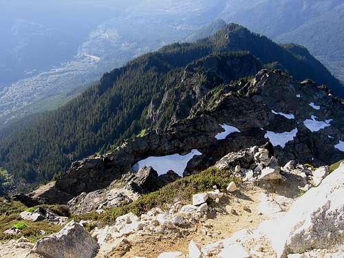
![The knife edge]() The knife edge from above. Stujack Pass is down in the gap, just beyond.
The knife edge from above. Stujack Pass is down in the gap, just beyond.
After taking a picture of Mt. Baker behind White Chuck Mountain I started up again. I had a brief burst of renewed energy anticipating the more interesting climb ahead. I started quickly up the scramble trail to the right of Stujack Pass. The trail was actually very good here and only slightly steeper than the trail below Stujack pass. The trail ascended about 400 feet up a steep heather slope with expanding views to the north and east. At one point I was so absorbed with the view that I accidentally kicked a small rock down the slope. I immediately spun around to make sure there was no one coming up the trail below me.
From here the going got rougher and I started to get tired as the trail ascended across the knife edge. There were a few places where the trail was blasted out of the side of outcrops and there were some big vertical drops immediately off to the sides. It wasn't nearly as bad as I expected though. The trail was wide enough and flat enough to feel comfortable. Still wouldn't want to take a misstep though. At the end of the knife edge there was a rock face that looked intimidating from a distance but was easy scrambling once you got right up to it. There was actually a wide slanted chute to scramble up, so the exposure was minimal. Just had to remember what the location looked like for the return trip as it didn’t appear that there was any other easy way down.
![Big Drop - E Side Mt Pugh]() Don't look here!
Don't look here!
Just as I got to the top of the chute I started to run low on energy. Not sure whether it was the altitude or the lack of sleep the previous night catching up with me. All I know was that I suddenly felt really sleepy like I could just sit down on a rock and take a nap. I sat down and guzzled the rest of my Gatorade hoping that would wake me up a little. At this point it was already close to 3:00 PM and I was debating whether to continue. I sat for about 10 minutes and took some pictures, but I was still feeling sleepy.
After resting for a good 30-40 minutes I had just made up my mind to head back down when another hiker passed me. He encouraged me to go on and told me that it wasn’t much farther. You know how that goes. I figured, based on the warm clear weather, that it would be okay to hike out in the dark. Okay as long as I was below the boulder field before sunset. I remembered the trail being quite easy to follow in the trees and if I got too tired I had extra food and water with me and an emergency blanket to sleep in. The sleepiness finally passed but I suddenly had to take a leak from all the Gatorade I had just consumed. It was a bit scary scrambling off the trail looking for a somewhat hidden spot. The slope was very steep here with some nasty cliffs below.
![Summit Panorama]() Summit Panorama
Summit Panorama
I made it up to the summit just before 4:00 PM. At the top I immediately snapped some shots of a glider plane flying around the summit. It looked like a lot of fun. If only the pilot could toss me a line and fly me down!
There was a large vertical drop off on the east side of the mountain. Looks like a 1500-2000 foot drop there. Check it out
here and
here.
As the sun got lower in the sky and the shadows lengthened my surroundings became more and more vivid. The sun was glinting off a narrow slit of Puget sound, just peeking behind the foothills. I was transfixed for a long time and couldn’t make myself start heading back down until close to 5:00 PM.
![Western Skyline from Mt Pugh]() Western Skyline
Western Skyline![Glider - Three Fingers]() Glider and Three Fingers
Glider and Three Fingers![Mountain Goat (on Mt. Pugh)]() A goat
A goatThe road back
![Looking towards Bedal from Stujack Pass]() Long shadows, nearing the boulder field
Long shadows, nearing the boulder field
The trip down was happily uneventful, though I did see one lonely mountain goat on the way back across the knife edge. At first it was walking across the small glacier, but it eventually climbed up onto some rocks where I could get some decent contrast.
I went very slow on the way down mainly because my back was hurting (ugh, forgot my ibuprofen). The sun was already almost behind the mountains when I reached the boulder field. It was pitch dark by the time I got down the switchbacks below Lake Metan. I found the silence a little creepy on that last stretch. Every little rustle of branches put me on edge. First time I’ve been afraid of the dark since I was a little kid. I was very happy to be back in my car around 8:45 PM. I got a Mountain Dew at the gas station in Darrington to stay awake for the drive back to Seattle.
Stats
[img:337118:alignleft:medium:Long shadows, nearing the boulder field]
Distance - 11 miles RT
Summit Elevation - 7201 ft
Elevation Gain - 5300 ft
Time - 10 hours
This was the first hike/scramble I've done with over a mile of vertical elevation gain in a single day. Also the longest hike I've done alone.
I took 5 hours up and 4 down, but that includes a couple long breaks and lots of short camera breaks. If I wanted to I probably could have gotten up in 4 hours and down in 3, especially if I hadn't fiddled with my camera so much and taken so many pictures. I'm not in terribly good shape though and didn't want to overdo it.


Comments
Post a Comment