
|
|
Route |
|---|---|
|
|
27.90400°N / 86.83370°E |
|
|
Hiking, Mountaineering, Scrambling |
|
|
Spring, Fall, Winter |
|
|
A few days |
|
|
Class 2 |
|
|
Overview
The Southwest Ridge Route is the only commonly used route used to climb the peak. It is a straightforward hike and scramble, never exceeding class 2 in difficulty. As mentioned, there are many rock climbing possibilities on the ridge beyond Nangkartshang Peak.Elevation gain above Dingboche is about 700 meters/2300 feet and the climb can be done in half a day from Dingboche. Pheriche is an alternate route.
The views from the summit are very worthwhile and this route is a fairly easy ascent (though there is some scrambling), especially by Himalayan standards.
 Kessler and a porter about half way up Nangkartshang Peak.
Getting There
The climb of Nangkartshang Peak begins in Dingboche; 2-3 days above Namche Bazaar, though extra days to acclimatize are very recommended. Extra days can be spent trekking and climbing to places like Thame, Jaro Ri, Khunde, Khumjung, Hamugon, Ama Dablam Basecamp, and Ama Dablam Lakes.Namche Bazaar can be reached on foot from several directions. The two most popular routes to Namche Bazaar are from the trail from Lukla Airport or the walking route from Jiri and Bhandar.
As of December 2012, only Sita Air and Yeti Air (which are basically the same company) fly to Lukla. Namche Bazaar is two days on foot from Lukla, and most people spend one, two, or more days acclimatizing in Namche Bazaar before heading higher to other areas, which is a very wise move.
Be aware that flights to Lukla can only fly in good weather and that sometimes planes are grounded for days.
The walking route from Bhandar to Namche Bazaar takes 8-9 days plus a long day’s bus ride from Kathmandu. Twelve buses a day leave from Kathmandu and from Jiri usually transport can be found to Bhandar.
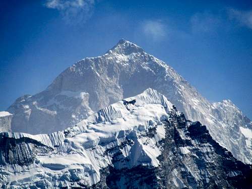 Makalu as seen from the summit of Nangkartshang Peak.
Approach
From Lukla, the main trail heads north and down to Cheplung. From here the trail continues along the Dudh Kosi River and ascends to Ghat and Phakding. Most people spend the first night here, but if you have time, I'd recommend continuing another hour or two to Benkar. This helps spread business between places that are normally used as overnight stops and allows a quieter experience as well. There are a few nice waterfalls around Benkar as well.From Benkar, the trail crosses the river and a bridge and ascends gradually to Chumoa and Monjo. It is here that you will have to show your permit and this is the first of many checkpoints. Jorsale is just beyond and is the last town before the long, but fairly gradual climb to Namche Bazaar. About 2/3 of the way up is a viewpoint with your first views of Ama Dablam, Everest, and Lhotse.
From Namche Bazaar, consider a longer route though Khunde and Khumjung. The direct route is a heavily used (and often dusty) trail passing through Kyangjuma, Sanasa, Tashinga, Phunki Tenga and then up the final long climb to Tengboche. If you are feeling ill at all, Phunki Tenga is the lowest place to stay in the Khumbu.
Between Namche Bazaar and Dingboche, the spectacular Himalayan views really open up and you are rewarded with great views of Thamaserku, Kangtega, Ama Dablam, Lhotse, and Everest.
From Tengboche, the trail continues northeast and down o Debuche before climbing to Pangboche, Shamare, Orsho (take a right just after Orsho) and Dingboche. Dingboche is the largest settlement in the Khumbu above Namche and makes a good base to climb Nangkartshang Peak as well as many side trips to places like Ama Dablam Lakes, Island Peak Basecamp, as well as climbing Chhukhung Ri and Island Peak.
 Nangkartshang Peak from the south and from near the Ama Dablam Lakes. Nuptse is upper right.
Route Description
From Dingboche, take the main trail that zigzags up the slope north of town enroute to the Mount Everest Basecamp. The trail climbs to a minor pass. From the pass, the route to the summit of Nangkartshang is pretty obvious and a pretty good trail leads to the summit.The views get more spectacular as you climb and there are several interesting cairns and prayer flag monuments along the way. Keep your eye on the slopes to the right and you will catch a glimpse of the Gompa. It didn’t appear to be inhabited on our trip.
There is some interesting and fun scrambling near the top. The views are absolutely spectacular from the summit. Cholatse, Nuptse, Taboche, Ama Dablam, Makalu, etc. surround you in all their glory.
Just beyond what is known as Nangkartshang Peak, the ridge immediately turns into a razor sharp knife edge. To continue one to higher peaks on the ridge without some serious technical climbing, you must descend Nangkartshang and skirt the cliffs to the north. You may reach the next peak without technical gear, but anything beyond that would be a mini expedition. The rock does seen fairly solid though and experienced climbers may be interested in pushing a difficult route between Nangkartshang and Pokalde (peak). Pokalade Peak is climbed occasionally, but usually from the northeast rather from this direction.
 The summit of Nangkartshang Peak in strong winds and flapping prayer flags.
Essential Gear
A good pair of boots is needed. Whatever you do, don't forget your camera!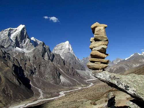 An interesting cairn on the ridge enroute to the summit of Nangkartshang Peak. Taboche is on the left and Cholatse center. Only a good pair of boots is needed to climb Nargkartshang.