
-
 6603 Hits
-
 79.04% Score
-
 10 Votes
|
|
Route |
|---|---|
|
|
47.87318°N / 13.83801°E |
|
|
Hiking, Via Ferrata |
|
|
Spring, Summer, Fall |
|
|
Half a day |
|
|
By the Austrian ferrata scale: B |
|
|
Overview
On the beautiful Traunstein three marked routes lead (in addition to some more scrambles and easy climbs). Naturfreundesteig is an easy ferrata, which goes in the vicinity of south-western ridge. It can be nicely combined with the other, a bit easier Hans-Hernler Steig. In this case it is more recommended to ascend by the Naturfreundesteig and to use Hans-Hernler route to descend. In 2001 we did the tour in the opposite direction, which was a perfect choice (done incidentally), because end of April on Hans-Hernler Steig there was still a lot of snow and Naturfreundesteig was almost perfectly dry.Rating the Route (With Hiking Standards)

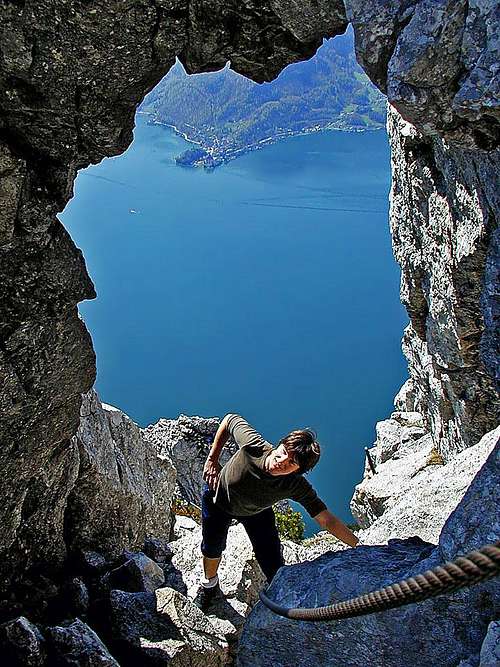 In the upper part, the ferrata goes through a nice natural window
0. General: You ascend from 430 m to 1691 m, exposition of slopes is S, SW and W. The route is a very nice ferrata, with great scenery and views down on Traun lake and on the neighbouring mountains. Experts like Eugen Huesler are rating the beauty of this route on the very top of Salzkammergut routes. For the ferrata, less experienced will find a ferrata set useful, otherwise good shoes and poles are sufficient. By the Swiss Scale for grading hikes, the difficulty would be T4. The ferrata part is rated B by the Austrian scale. Best time to ascend is from May till October.
1. Effort: 1260 m, 4 h for ascent, 2 h 30 min for descent.
2. Power: 3 - medium on ferrata sections, otherwise a lot of walk up.
3. Psyche: 3 - medium.
4. Orientation: 1 - no difficulties, well marked all the time.
Getting There
See the main page of Traunstein how to get to the end parking place on its east shore. From Gmunden you drive till the Hois'n restaurant, 430 m. Naturfreundesteig is the second one, south of the inn. You walk along the lake shore till before the bridge over Lainaubach, where the ferrata starts.Route Description
From the very entry we start climbing steeply up over the rocks. So, already the first sections are picturesque, on many places exposed, but well protected. Later, the rocks are overgrown with light woods, but the scenery is still very nice. On some 800 m of altitude we reach a notch with a picturesque rock tower, soon higher the route goes over a short, but very steep rocky wall. This is the hardest section of the route, over which a metal ladder and cables help you. Above the place, called "Hohen Rast" the route sticks to a distinct ridge, but higher again leaves it towards the left and crosses a bigger, rocky basin. Now we are already below the last steep part of the route. The path turns up over the rocks and soon goes through a beautiful natural window - "Felsentor". Above it, only a few more turns up over a steep rocky slope and we already reach the Naturfreundehaus, 1575 m. From there you have some 30 minutes more to the summit of Traunstein - only a comfortable walk-up.For the descent we use either the same route, or choose the Hans-Hernler Steig, which brings you closer to the parking place. The third option would be to descend southwards, on Mairalm. But also that path is not just easy (ferrata sections of difficulty A), and the return also goes much around the mountain.


