
|
|
Route |
|---|---|
|
|
44.08019°N / 114.95064°W |
|
|
Scrambling |
|
|
Summer, Fall |
|
|
Most of a day |
|
|
Class 3 |
|
|
Overview
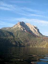
 Grand Mogul - NE ridge is dead center
The Grand Mogul is the dominant peak to the south of Redfish Lake, and anyone who has taken the shuttle across Redfish Lake has no doubt taken notice of this peak. While many who aim for the summit of the Grand Mogul will opt for the Chockstone Coulior Route, those less technically inclined or those attempting the summit in the summer months will opt for the north east ridge to achieve the summit. As with all routes on the Grand Mogul there are no trails and cross country travel, albeit a short distance, is needed to reach the route. The route its self is solid class 3 although there are many route finding challenges along the way. It is suggested that you have at least an intermediate level of experience with class 3 terrain and route finding before attempting this peak. Not to say that that gaining the summit along the north east ridge is a daunting task, in fact it can be quite a comfortable and enjoyable route, but there have been fatalities on this peak. Exercise caution and you will be fine.
Getting There
Take Idaho Highway 21 to Stanley and turn right (south) on Highway 75. From there drive a short distance to Redfish Lake Road. You could also come from Sun Valley / Ketchem north on Highway 75 and turn left when you get to Redfish Lake Road. Follow Redfish Lake road to the lodge and park. From here it is recommended that you take the shuttle across the lake to avoid the 5 mile long trail that follows the lake. As of 2012 the cost for the shuttle was $16 and seems to rise every couple years. You can call ahead to find out the current cost if you’re concerned. It is well worth it, as it saves you 5 miles each way. The shuttle will leave on demand of 2 or more people and will pick you up after you’re done at set times (12, 3, 5, or 7) or if you are there waiting when the shuttle comes to drop another party off. The route begins at the Redfish Inlet Transfer Camp.Route Description
 The start of the NE ridge
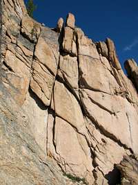
From Redfish Inlet Transfer Camp, follow the signs to Lilly Pond. It is only ½ mile to Lily Pond, which is aptly named (full of lily pads) and the cross country route begins here. On the trail to Lily Pond you will catch glimpses of the Grand Mogul. Once you pass Lily Pond head off into the forest aiming for the north east ridge, just left of the big gully. You will encounter some bushwacking at this point, but it should be manageable. You may be able to find a dried up drainage / creek to climb up to avoid the shrubs which is usually a good thing. Once you get to base of the NE ridge route you need to make the first of many route finding decisions. In this photo, the small red dots take you up the start of the class 3 route with one section which is slightly sketchy in that you will be pinned up against steep slab on the right while navigating up dirt covered rock for about 40 feet. The footing is not the best but it’s doable. Alternately, the blue route will take you up a gully between the two cliff bands. The gully is somewhat steep and mostly dirt with a few boulders and is mostly steep class 2. The black route is another option which would take you around both cliff bands and would involve more bushwacking. All three routes join above the cliff bands and continue up along the NE ridge.
 NE ridge cliffs
The next 1000 feet or so consists of lots of low angle slab climbing. The slab is at an angle where for the most part you can just smear (use shoe grip) and basically walk up most sections of the slab with occasional use of hands, more in some places, none in others. It is worth noting that at this point, try to stay to the left of any major cliffs or rock formations. It can be tempting to try to climb up to stay on the highest point of the ridge, but you will undoubtedly get cliffed out and have to retrace your steps to find another route. Just stay to the left and follow the slabs and rock ledges.
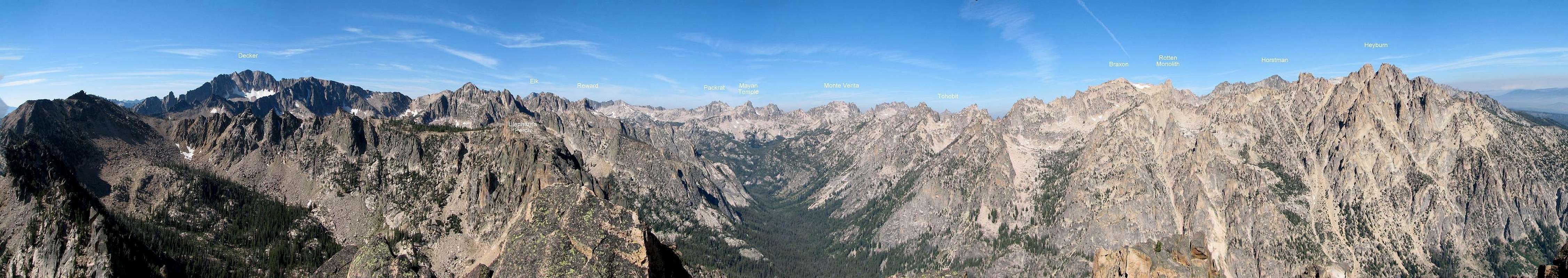
When you get closer to the top, the summit appears just a couple of class 3-4 boulder moves away. STAY LEFT! Again, you’re likely to get cliffed out climbing up too early. You’ll basically want to follow just below and left of the NE ridge and follow it around, finally gaining the final summit block from the east. There are a plethora of potential routes in and around the boulders and ledges so route finding is important here too. Once you make it to the top, you’ll be rewarded with this panorama (click here for link):
  |
 NE ridge route topo
Alternate routes (can be used for ascent or descent) are seen here in blue. The blue dots is a pretty easy series of boulder hopping and scree which can be great for the descent. On the downside, the blue dashes can lead to some steep sidehill and/or dense bushwacking so keep that in mind.
Total Distance: 8.7 miles roundtrip
Total Elevation Gain: 3538 feet
Estimated Time: 3-7 hours. 3 hours (if you run up), 5 hours (at a decent pace), or 7 hours (if you are slow or take extra time to enjoy the mountain).
(distance and elevation via SawtoothSean's Top 10 Sawtooth Peak Scrambles)
Camping
Camping is plentiful near Redfish Lake. Car, RV, or Trailer camping is available at several locations. Check out this link for general Redfish Lake Recreation Complex information. Point Campground along with Glacier View Campground and Outlet Campground all require reservations. Visit recreation.gov and enter the name of the desired campground to inquire about availability. Heyburn and Sockeye campgrounds are available first come first serve.Backpacking is possible, but this is mainly viewed as a day hike although it would be possible to incorporate the Grand Mogul into an overnight trip if you so desire.