New England Summitfest #4
![]()
My biannual trip to the Northeast took me to the place where NE SF#1 began, New Hampshire (which, by the way, has THE best state motto ever). Ever since my friend Brian (Flanders) and I moved away from the Chicago area to opposite sides of the US, we've gotten together each year, taking turns on each other's coast, for a hiking trip. Originally, we had talked about the Taconic Range for this year, then the Adirondacks, a few others, but finally, we settled on New Hampshire and an attempt to bag more 4000ers.
I caught the red eye out of Portland on a Friday and was in Newark in the morning. Another quick shuttle flight up to Providence and I was in Brian's car headed to REI and a grocery store for provisions. Soon after, we were breezing up to Woodstock jamming to Grunge, trance music, German oompah tunes and other assorted nonsense from my Ipod.
We were going to set up camp on his friend's acreage outside of Woodstock on the Pemigewasset River. We'd camped there before and it is a great basecamp for the area, but first, we were going to do a warm-up hike on Mt. Tecumseh.
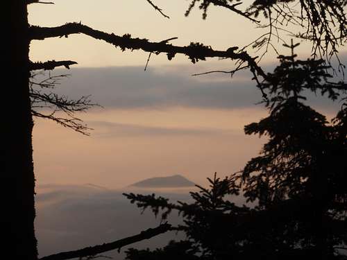
![]()
View from the trail on Tecumseh
We had some trouble finding the right place to park because 1) a ski area is a weird place to be in the summer, 2) the directions are somewhat vague and 3) we were driving the wrong way on the loop and all the signs were facing away from us. Somewhere along the way, one us of checked a mirror, we figured it out and found the right spot near the trailhead.
I changed clothes from the ones I still had on from my flight out and we headed off into the woods. It's a nice hike with a babbling brook somewhere around off to the left although we never saw it. There is a nice viewpoint along the trail where a ski run jogs through but before we knew it, we were nearing the top. The actual summit is less than thrilling with very little in the way of views. After the summit, we started off down a trail we thought would be a loop back but it soon seemed like it just went down and away from where we wanted to head so we clambered back up and back the way we came. However, we decided to do a little side hike that appeared on the map that weaved through the trees. The payoff for this effort was a Nextel communications hut or something so it is totally not worth the effort.
That added a mile to our hike but we quickly got back to the trail and back down to the trailhead. The guys standing in their shorts in the parking lot drinking beer when we left had NOT vandalized our car so we were very happy. We headed back to the campsite and spent a chilly night around a roaring bonfire Flanders built on the riverbank. That sucker had STYLE! Flames about 4 feet high and a fireworks display of sparks from the dry woodpile we were drawing from. If anyone can explain to me how to load a "movie" onto summitpost that I took from my digicam, let me know and I can show the fire dance Flanders does when he knows he's on camera. :- )
The next day we upped the ante and wanted to hit Moosilauke, supposedly the peak with the best views in the area (although most guidebooks seem to say that about every peak in New Hampshire). We promptly started off at the wrong trailhead from a highway instead of driving a mile or so up a road we would have to cross anyway (don't ask, I was navigating and I don't want to talk about it-Flanders flipped me enough shit about it already).
Right off the bat, there is a somewhat-steep plunge down to a stream crossing and then a tromp through the woods to a road. We did run into a bunch of wild turkeys hanging out on the side of the road though. You walk up the road a bit, then a bit more past a cemetery or something, then take off into a nice meadow. The meadow was sunny and warm and things were looking up now.
![]()
The Meadow on Moosilauke
More woods that I don't remember too much about followed. I do remember a neat traverse to our left that was relatively flat for a while where we stopped for lunch. These hikes are great each year with each of us catching up on all the harassment to each other we miss the other 51 weeks. Flanders and I used to work together in the suburbs of Chicago and although we email each other all the time (don't tell our employers), there is just no substitute for quality put-downs, slams and bringing up embarrassing moments from our pasts. At least it's different than the ones our wives fling us and seems funnier in person on a hike.
So, after some jerky and jabs, we headed up again along the rocky path and were soon breaking out of the trees on the summit. Only problem was, it had clouded up and was kinda nasty up top. We also ran in to the rest of the world up there hanging out in the fog and wind. No views this hike!
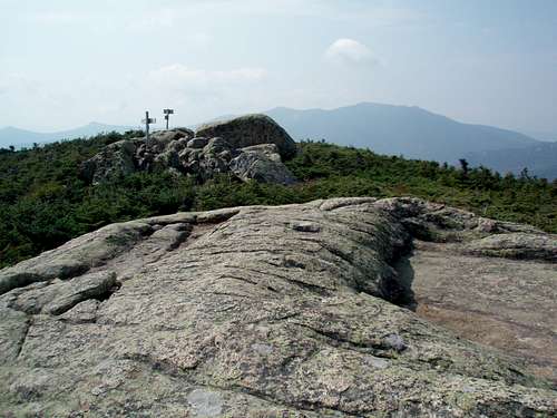
![]()
Not much to see on the top of Moosilauke
Going back down was uneventful. Before retiring to our camp that night though I had to hit some sort of outdoor store in Lincoln, NH to get a sleeping pad. The valve has failed on it the night before in one of those moments from a sitcom. Me lying on me back with the air whooshing out under my weight.
The selections for outdoor gear are slim in Lincoln. There was a cheapo store on the south side of the main road and what looked like a real outdoor store (I think it was called the Summit Shop or something.) on the other side but it was closed. So I ended up paying $30 to buy two foam pads that were unbelievably cheap in quality but did the trick. (I would later donate them to the Flanders clan so his boys could play in the backyard with them.)
Another rousing fire by the river that night with us eating dehydrated food in the dark. We were really starting to make a dent in that woodpile now.
Apparently, Flanders plan for our trip involved progressively more involved hikes each day so our Day Three plan was going to tag the remaining two peaks from Franconia Ridge we had missed on New England Summitfest #1 in 2002 - Flume and Liberty.
We were heading up the Slide Trail on Flume which I must say is great fun. Wait, back up a bit, it took us a while to get to the right trailhead. While it seems convenient that these trailheads in this area are right off the highway, if you miss the correct exit you have to go a ways to find one to turn around on. Anyway, with a bit of driving we got to the correct TH and headed off on a trail that kind of parallels the highway for a bit before turning into the woods and up the mountain.
The trail is nice and apparent and when you come to the junction a ways up where you take a right to follow the Slide Trail, it changes to be a bit thinner and apparently, less used. And judging by the fact we saw no one until we hit the summit, it probably is. (This is a hint to all of you looking for a peaceful day.)
![]()
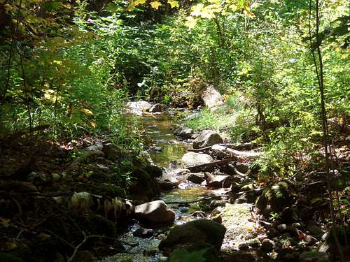
Lunch Spot on the Slide Trail
We had lunch by a wonderful brook just before the trail becomes the "Slide." Once it starts getting rocky and steeper, the fun begins. This is not a large open obvious slide, in fact, I'm not sure it is a slide at all although it must be. It just seems like a giant 20 foot wide brush scoured the mountainside for a thousand feet or so revealing the granite underneath. Undulating slabs lines by small firs and some moss weave back and forth on their way up the hill. It was supremely fun and one of the highlights for me as you have to pick your way around the rocks and use your hands. The sun was out and it was warm and we took a break on a little ledge in the middle of the rocks with our feet dangling over watching the peaks across the valley.
![]()
On the Slide Trail
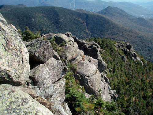
Eventually, the rocky "slide" ran out and we reentered the forest for a bit before coming suddenly to an open rocky area. Was this the summit? No, but close. We were on a cliffy area and the trail wound along the edge and over a bit to the actual summit where we met a couple and chatted with them a bit. Their accent was Jersey-ish and seemed out of place but then I realized I guess I was more out of place being from Oregon so why don't I keep my opinions to myself, eh?
![]()
Flanders heads to Flume's summit
After a quick bite, we headed down into the woods in the dip over to Liberty. It doesn't take very long to hike the saddle, down and up, to the open summit of Liberty. There is a little scramble near the top and you pop out in the sun again on a big bouldery open spot. We didn't hang around very long and once again we headed down. I forget which trail we took but it headed off the peak the opposite way we came so we were making a big loop down to the trailhead.
![]()
Looking south from the summit
There is a neat "zone" on these peaks just below the summits where the fir trees are not very tall (although taller than krummholz) and the forest floor is covered in moss. I really dug hiking through there and imagined coming to an open spot where my secret cabin would be.
![]()
Flanders heading down north off the summit
Once we were below that zone, the trail really just went down through the forest among the changing leaves, mossy rocks and small waterfalls. We passed a campground and then just kept going until we popped out at that same junction where we had taken the right to head up the Slide Trail. Soon after we were back at the trailhead.
I don't think we built a fire that night. The one the night before was so large, the flames were lapping at the leaves in the maple above us. Astronauts in the Space Shuttle had called the landowners so we decided to lay low this night. I got to sleep again on my excellent compressed foam that shredded and tore a little bit every time I rolled over.
So, Day Four was going to be our Big Adventure of the trip. We would start our only overnight hike by heading up the Bonds and hiking up the ridge to Galehead Hut hitting all the 4000ers we could in the Twins Range and then back down the valley in another loop hike.
We were up earlier as we wanted to get a good start on this day. The hike would be over 30 miles with lots of elevation and we wanted to make sure we got to the Guyot Campsite in time to get a spot. We didn't know if there would be a crowd but figured not as this was the middle of the week. Still, there could be some leafpeepers out there who might want our campsite!
The Liberty Springs Trailhead is more like a ski hill parking lot. I'm not sure why it is so large but maybe a lot of people come here to hike the flat railroad grade trail along the river and then go home. Anyway, we quickly filled out our parking permit and were off.
The trail starts with a long bridge crossing and then a really long hike along a flat trail that obviously used to be a railroad. We kept accidentally kicking and almost tripping on the mostly-buried railroad ties that cross the path until we found the worn paths on the side of the ties where other hikers had avoided them.
The trees along the trail here were starting to really get some color in the leaves and I stopped to take photos along the way (who is the leafpeeper now?). We stopped for a break at one point and were sitting by the side of the trail which was so wide at this point, it was like waiting at a bus stop on the side of a road, except it seemed like we were back in time and were really waiting for a carriage to come up (or a headless horseman).
![]()
Waiting for the Headless Horseman on the trail
After I think about 3 miles of this, the trail forked and our way to Bondcliff was to the right. It immediately grew to a very thin trail hemmed in by underbrush and somewhat swampy (this would mean more to us later). The river we originally crossed was still on our right but we were ambling more on this path back and forth. Eventually, we came to a stream coming down from up on the left and we had some lunch.
![]()
Lunch spot on the Wilderness Trail
From the maps, we could not tell if there was going to be much water from this point on until Galehead Hut. So, we loaded up with 4 liters each and headed up the Bondcliff Trail. The trail actually goes along this stream for quite a while but you never know when it is going to run out unless you've hiked it before. Anyway, we huffed our way up for what seemed a long time. The forest eventually gives way to more rocky ground and there is a part where the trail wanders over some dry streambeds (at least dry this time of the year) before reaching the top of the ridge you've been on. There is another ridge to the left (west) that you can now see in some open areas and the trail does a semi-circle to the left to gain it.
More rocky trails and bullshitting between Flanders and me followed. Our hiking conversations run a wide variety of topics from us deciding we should run for President and Vice President to who would win in a Battle Royale between one of those mining vehicles with the huge drill on the front and a semi-truck with a nuclear weapon in the trailer to whose feet hurt the most (or least if we are trying to act tough) to where next year's hike is going to be. I can't remember what we were talking about just that we had plenty of time to talk as we were in the trees for a long time.
Eventually, we did come to a small rock wall in the middle of some krummholz. It actually is an easy scramble up but signifies that we were getting close to breaking out of the trees. Which is what we really were looking for this hike, a nice long ridge hike with views. (And although there are plenty of views, this turns out to be more woods that open ridges.)
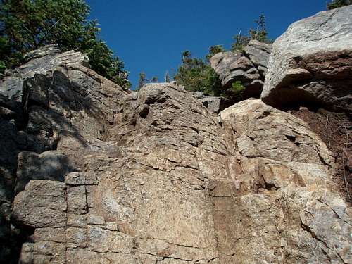
![]()
Scramble Spot
Once things did open up, the views were stupendous. Bondcliff is an extension from Mt. Bond with blocky cliffs on the northern side of the ridge. The rocky terrain is open with some small plants but you can see the ridge extend up from Bondcliff to Mt. Bond, across the valley to West Bond and to the west is where we were the day before; Franconia Ridge with Flume, Liberty, Little Haystack, Lincoln and Lafayette running left to right. In between this ridge and that is an island of a mountain in the valley below called Owls Head. It doesn't look like an owl head to me but remember; I'm a foreigner in these parts, who knows what crazy story there is along with that moniker.
![]()
Bondcliff from just before the summit
So, we enjoyed the afternoon sun up there, had a bite to eat and then headed off the ridge to Mt. Bond. Flanders passed me up here as I was taking lots of photos of the cliffs. I also was playing with my digicam taking movies of my shadow hiking, explaining where I was on the hike, etc. I find I like taking movies with my camera to capture the moments that still photos don't get. Or, maybe I just like the sound of my own voice, I don't know. Either way, he was way ahead of me on the ridge and moving up.
I followed and was really enjoying the views now. There is no place like being in the New England mountains in the Autumn. If you've never been there in late September/early October, just go. It's awesome.
By now I couldn't see Flanders anymore as the trail was ducking in and out of the krummholz. I just chugged along now as I couldn't see over the trees and soon came spurting out of them to the open summit of Mt. Bond where he was waiting.
![]()
Bondcliff from Bond's summit
It was late afternoon and our plan was still to hit West Bond before getting to the Guyot campsite so we didn't waste time and hit the trail. Like the Flume/Liberty hike, this one didn't take long as soon we were at the junction in the saddle between Mts. Bond and Guyot where a trail heads off left along the ridge out to West Bond. West Bond is a peak along another ridge heading out west that is listed as a 4000er so we had to tag it, right?
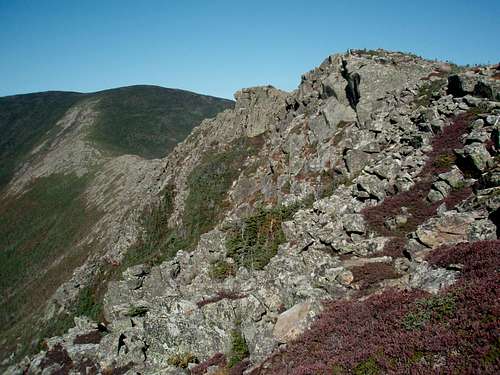
We stashed our packs in the woods and bounced out to West Bond in like 20 minutes. There is a fun scramble near the summit where you just barely pop above the trees to some of the best views in the area. All the mountains are around you on this perch.
![]()
Summit of West Bond looking south to Bondcliff
Unfortunately, light was starting to fade and we had to move along so we moved quickly back to the packs where mine had fallen off the tree it was hanging on. We got back to the main path, made a left and before we knew it, we were at the marker for the trail to the campsite.
We headed right following the signs to the Guyot Campground and were immediately dismayed to see it went down steeply. We were thinking about the hike back up in the morning to regain this path and kept getting more and more bummed as it just kept going down the rocks like steps. A couple hundred feet down, a large canvas tent sat on the side of the trail where the girl who was hosting the campground was housed. We chatted with her shortly and then took the first campsite on the right. It had a decent view out to the east and seemed fine. We just mainly wanted to not descend anymore I think.
Turns out the descent to this site has a reason. There is a spring where water comes out here! Guess we didn't have to lug all that water up from our lunch spot after all but we didn't know. (Take heed others who want to do this hike. This spring runs year round they say.)
We had some dehydrated dinner and set up our tent. As we were getting ready for bed, we heard a noise in the woods to our right. Flanders shone his headlamp over there and caught some eyeshine. There was something the size of a small coyote or fox looking at us and making a circle around the tent sites. It bounced into the woods and down by the another camper. Eventually, it came around to our left, then up and around and made another circle. Flanders kept hitting it with his light and I guess it figured its cover was blown and we heard it head off up the mountain. I never caught what it was as I had taken my contacts out earlier but our best guess was a fox or maybe a pine marten? I don't know if there are coyotes up around 4000 feet in the mountains of New Hampshire but those suckers are everywhere else so maybe? (Anyone reading this able to tell me if there are any there?)
![]()
Morning view east from the campsite
Got up the next morning to a low fog in the valleys. Hit the trail early and reclimbed that few hundred feet to the main trail. Soon after we were actually in the fog nearing the summit of Mt. Guyot which was really just a bump along the way. We couldn't tell where the summit was but just kept going on a side trail to nab Zealand Mountain, another 4000er. About halfway there, we realized we could just stash the packs so we didn't have to carry them all the way there and back so we did that. Then we scooted along really fast to the summit which was a disappointment to me. I had spent my honeymoon in New Zealand about 7 months earlier and just wanted to see a cool summit for this namesake. Unfortunately, it is a cleared spot in the trees with a sign, no views.
So, we didn't waste time there but bounced back up the trail to get our packs and retrace the trail to Guyot. By the time we got back there, the clouds were gone and we could see. Now, we had the longer hike north to South Twin Mountain.
Most of the next section is in the trees but there are a few views along the way. There's just not much to write about, it was like a couple or three miles pretty much straight and flat. Over some humps but then just before you finally get to South Twin, you start climbing for several hundred feet.
When we finally did pop out of the trees we were right at the summit of South Twin. By then we were a bit hot and in need of a rest so we sat in the sun at the summit and chugged some water and ate food. Our next objective was North Twin which was a side trail to the north. We figured we'd find a place again to stash the packs along the trail away from this summit.
![]() Summit of South Twin
Summit of South Twin
Looking north to North Twin![]()
So, we headed through the lower trees to the north, found a hidden spot along the trails for the packs and made our way to North Twin. It goes pretty quickly and once you dip down to the saddle and then start going back up, you run into a few rock outcroppings to skirt or scramble. The summit is along the trail with another marker, no views, but, there is a viewpoint a few dozen yards away that looks west over to Garfield Mountain and you can see the Galehead Hut to the southwest. That was our next objective. We'd have to retrace the trail to our packs and the summit of South Twin and then take the steep trail down to the Galehead Hut.
So, we did that. Ran into a guy on the summit of South Twin with a couple of friendly dogs (more friendly than he was at least). The trail down to Galehead Hut does just that. It goes doooown. Steeply, with a lot of rocky steps. You lose like a thousand feet in a mile (or something like that). It's a straight line, no deviation from the summit to the hut, no messing around.
![]()
Flanders descends to Galehead Hut
When we got there, we went in. I had underestimated how much food I'd need (which NEVER happens, I usually carry way too much). But anyway, I needed some food and the Hut obliged. They had some cinnamon sticky bread I bought along with a few power bars. We rested a bit and then left our packs in the hut to hit Galehead Mountain, another quick side trail to a 4000er. Again, this one was a lousy pile of rocks in an opening on a tree-filled and viewless summit. Fortunately, about halfway down, there is a great viewpoint you can walk out to that views the entire valley. We could see the Bonds, South Twin, the Hut, Owls Head in the middle of the valley and the Franconia Ridge to our right.
But, by this time it was getting to be late afternoon and the slog part of our hike was now upon us. We had basically done a half-circle north with 4 side trails. Now we were poised to drop all the elevation we had gained into the valley between the Twin and Franconia Ranges and slog out the valley floor all the way back to the trailhead we started from. Originally, we had planned to do another side trail to Garfield Mountain but in looking at the map, it was a significant elevation gain over there and a longer hike out and we figured at this point, it'd be after midnight when that happened. So, we just hit the trail (Twin Brook Trail) heading down to the valley floor from Galehead.
And down we went. Flanders got a bit ahead of me on the descent as I stopped to take some photos of the Fall colors. There were a few parts in the fading light that had some really bright mapley reds and birchey yellows. I followed and every now and then would catch up but we continued like this until we took a break about halfway down to the valley. After that we hiked pretty much together until we hit the valley floor and met up with the Creek. There are a bunch of waterfalls (supposed to be 13) but we only saw one as we headed quickly south.
![]()
Hiking the Twin Brook Trail down from Galehead
The trail on the valley bottom got back pretty much to a railroad grade. Not sure if this actually was a railroad but if it was, there are a few bridges missing now as we came to a couple creek crossings where we had to hop boulders across. And by now the light was really fading. We huffed and made great time along the trail but soon had to break out the headlamps. The batteries in mine were fading and Flanders has a great Princeton Tec one so he took the lead and I basically got the job of staring at the backs of his legs which is all the further my headlamp shone.
So, we cruised along, the path is pretty straight here heading south with a creek off to the right that we only heard and a few small brooks coming down the hillside from our left that we had to keep watch for as that was where the trail went up or down on rocks.
We were cruising along in the darkness, bs'ing and joking when all of a sudden the trees on our sides disappeared into black and the trail stopped with black in front of it. It was like a little peninsula of a trail that stepped into a void in space. At least that is the way it looks at night in headlamp light.
We looked closer on our sides and saw it was water. Same in front. The trail seemed to just head straight into a lake. Flanders' headlamp shone as far as it could and we could maybe barely see the other side where it looked like more woods but we couldn't see if it was a trail on the other side or what.
We broke out the map and could not find anywhere on it where there was a lake. There was a swampy section on this part of the map and so we figured we were there but somehow, the trail had either moved or we got off on an unknown side trail not on the map.
So, we retraced our steps to see if we missed something. No, we hadn't. We went back to the water "void" and from there, I noticed there were 4 small tree trunks that were laying side by side in the water. I followed the trunks and it looked like they went across the water to some dry land. And clearly, these hadn't fallen precisely like this, someone had put them there.
We stepped out onto them and gingerly made our way across. No telling how deep it was here, couldn't be that deep but all the deeper it needed to be was higher than our boot tops and it would make the hike out miserable. So, we carefully got across and found it was a burm of land of some sort that made a sharp left (good, that's the direction we needed to head). We could see what looked like a low mound of dirt or sticks or something ahead of us that stretched into the darkness. Sounded like water falling on the right so this was the only way to go.
A few steps into it, we realized what it was and the mystery of the trail was known. We were on a beaver dam! Some large flat-tailed rodent had decided to dam this up and make the trail disappear in a pond that would have been readily apparent in the daylight but in the pitch black of a forest on a valley floor, could have been the Mines of Moria for all we knew.
We walked to the other side and as expected now, we found the trail on the other side. Now, we were set to cruise out. Well, almost. Along the way the straight trail as we expected would suddenly end in weeds now and then and we would have to search in the night on either side to find a worn area where the trail went around something and then back to the expected route. I'm sure during the day this would have been nothing of consequence but at night, it was one mystery after another which we had to overcome.
And at one point chugging along the trail, we suddenly heard splashing in the water to our left. We stopped short in our tracks wondering if a bear or something was out there thrashing its way toward us. We head a low guttural grunt. Shit!
But, we doubted it was a bear since it was coming from the water. Then we surmised moose! And I¡¦m not sure about you, but the idea of staring at a bull moose with a spread of antlers from my vantage point was not inviting. I know from running into a bunch of these in the past in the Boundary Waters, MN, the top of my head doesn't even reach as high as its shoulders. This was a thought much worse than a bear.
![]()
Hiking out just before dark
The splashing sounded like it was getting farther though. Good. Very good. We decided we needed to announce our presence much louder from here on out as we toiled in the swamps. So, we plodded along talking about absolutely nothing but saying it in loud voices. "How are the kids?" "They are fine, how are your feet." "They hurt, and yours?" Etc, etc all the way back along the trail for another hour or so.
The path stayed pretty swampy all the way until we ran into a sign on our right. It was where the path from the other side of the valley joined this one. That one comes down from Garfield Mountain and works its way around the west side of Owls Head (where we had gone around the east side) to join up here and head the final distance back to the railroad grade trail we came in on. We churned our way down this and finally after hours in the darkness, we were unceremoniously dumped out back on the wide old track.
It was somewhere in the 50's this time of night (about 9 pm or so) and we could see our breath but we were hot and sweaty so we didn't want to break long or we'd get really cold. A quick break and we were back on our way. There was nothing much to talk about except for how hungry we were and what we wanted when we got back to the car. It was going to be about 10 pm and we wanted grease. The only place we could think of in Lincoln was McDonald's so we talked about quarter pounders and Big Macs and shakes. We also talked about our feet a lot. The bottoms of mine by this time were screaming at me. Flanders had strained an Achilles tendon on Galehead and was trying to ignore that and just get back. The hiking by now was boring and flat and all you can do is focus on the things that are annoying you. Several times I had to stop for a few seconds and pick my feet up one by one to let them rest and Flanders would have to wait since we were basically just going off the light from his headlamp at this time. I didn't want to dig into the bottom of my pack and get the spares for mine.
On we plodded and not soon enough we reached the bridge over the river back to the parking lot. There was no one else around this time of night and we dumped the packs in his car and pulled out the wallets for the fast food!
We got the bag o' food and headed back to our campsite where I would have to set up my tent again in the dark. When we got there and pulled out the food, I realized they had screwed up my order. Nice! Flanders made fun at my outburst but as I scraped off the crap they put on I didn't want, all I could think about was my misfortune.
Didn't stop me from eating it, mind you. At that point, I could have put ketchup on my socks and eaten them. I downed it just fine but submit this to all of you-the McDonald's in Lincoln, NH sucks!
There, I've said my piece. It's over now.
Back to my story. After a wonderful sleep, we got up and decided after all of the hiking we've had and the 30-some miles we'd just done, we were taking a rest day. We headed into Woodstock or North Woodstock or South Lincoln or whatever the hell name the town was and did some shopping for our wives/kids. Later, we chatted with Flanders' friend whose land we were camping on and she let us check the internet for weather updates. And as we found out, a large storm was moving in the next day all along the Coast from Maine to Maryland and inland too. There was going to be nowhere to go that would be dry. Rather than spend a wet night at camp and hike in the rain the next day, we decided to head back to his house where we could have a dry night before heading somewhere the next day in the rain.
Back to Massachusetts we drove. Stayed at his house that night and decided to hit one of the remaining state high points we had not tagged yet, Connecticut's Mount Frissell.
The drive there went quickly the next morning. We did miss the huge concrete marker that denotes the Mass/Conn border. Don't know how, the thing is like a small version of the Washington Monument. But we did the first time. So, after some driving around the woods of Connecticut, we did find our way back and see it.
The trail was nice. The trail is short. The trail was wet though and we took care on the rocky spots not to slip. We came out of the trees into very windy and somewhat wet conditions. Stepped on the high point, walked a short other distance to the true summit and then headed down. Nothing to see, just wind and rain.
![]() Hiking up Frissell
Hiking up Frissell
Connecticut's Highpoint![]()
On the way down, we remarked that we wanted to hit something else. That hike is barely a warm-up on Frissell. Cool, but very short. (Don't dis the Friss!) We decided to hit Alander Mountain nearby. It's a short drive and we were there quickly.
A nice meadow walk starts out the hike, then you go down to a creek, actually, a couple of creeks where there are some nice small waterfalls. Then, on up the trail in the woods. We started noticing bright reddish orange newts all over the trail too. Later I found out they were Red Spotted Newts and they were everywhere. They must love these light rain conditions and were out in full force.
![]()
Red Spotted Newt on the trail
We took care to not step on any (which was a chore since there were so many) and I followed Flanders up the mountain he had posted on SP. We got up to a small cabin and then shortly above that was the summit area. An open, shrubby rocky top where I'm sure are great views on clear days. This was not a clear day though and we couldn't see crap. Sometimes the clouds would open a bit and I could see down to the valley below but there was nothing but wind there now so we headed back down.
The hike out was quick and no newts were harmed I'm glad to say. We did see some turkeys along the roadside driving in but not out. We drove to what has to be one of the most idyllic New England towns I've ever come across, Great Barrington, Mass. Talk about your picturesque forested hills and cattle in fields and white steepled churches and town squares with quaint shops. This would be the site of one of our traditions, the end-of-vacation pizza. We had spotted a pizza place on the drive in and marked it for conquering on the way out.
We ordered our pizza and sat down to wait for it and I was wondering why there were all these photos on the wall of places in Greece. Flanders told me this was a Greek pizza place as were a lot of them in New England. He said we had ordered a Greek-style pizza.
Oh no! Thoughts of the botched hamburger two nights before danced in my head. Another messed up meal. What the hell did the Greeks do to pizza? Was there going to be baklava and lamb on it?
Flanders then relayed to me that it was just a thicker crust, there was still marinara sauce and mozzarella cheese and all that. Phew! Crisis averted. And a good pizza was had by us in Great Barrington, Massachusetts (with the Greeks).
By the time we got back to his house and I was packing up to fly back home, we'd covered 64.6 miles in 6 days of hiking and gotten in over 19,350 feet of elevation while tagging 14 summits. Not too shabby for this Fourth Edition of our New England Summitfests. We've decided to finish out the New Hampshire 4000ers so look for more to come in 2 years. Next year is his turn to come west and I have my eye on the Wallowas in eastern Oregon.
![]()


 Summit of South Twin
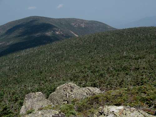


 Hiking up Frissell
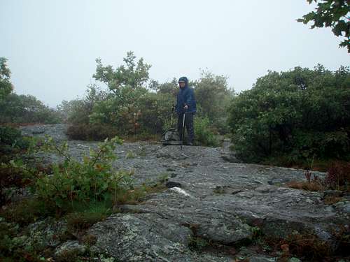


Comments
Post a Comment