
|
|
Route |
|---|---|
|
|
37.89000°N / 107.5333°W |
|
|
Hike |
|
|
Half a day |
|
|
Class 2+ |
|
|
Approach
You can get very far up the road with a regular 4WD vehicle (ie high clearance but no special gear). This hike is accessed by driving south on CO149 to Lake City. Pass through Lake City turn right on San Cristobal Road and drive along Lake San Cristobal's west shore. Go past Williams Creek trainhead, past Mill Creek Campground to the junction of Sherman and Cinnamon Pass roads in around 14 miles from the right turn. Go on Sherman Road (county road 35) and pass the Cataract Gulch trailhead, at this point the road gets rougher and you need a high clearance 4WD. Go past Cataract Gulch trailhead heading west up Cottonwood Creek's north bank. Cross a creek in 2 1/2 miles and pass the parking area for Cuba Gulch (you can start the hike here but it adds 6 mi round trip!). Continue along the road and switchback 2 times. Go another 0.6 mi west and hit the bottom of a series of switchbacks up a huge screefield. This climb is called the Snare Stairs and it is easier than it looks. The road is good and flat, if rocky, and the switchbacks will fit a reasonable sized vehicle (we did this in a Nissan Xterra I could have done it easily in my Toyota T100). Its not really hard 4WD driving. The road switchbacks 12 times with some impressive views back down to the bottom. Once you are off of the Snare Stairs keep heading west and pass an old cabin on your left. The road switchbacks a couple more times then go a half mile or so to reach some good parking at 12,040 feet at an old mine site. More details of this drive can be found in Gerry and Jennifer Roach's book Colorado's Thirteeners from hikes to climbs (a must have book if you do a lot of hiking here).
Route Description
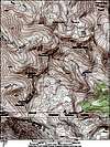
From the parking area at the mine site head southeast along a good quality 4WD road. This road follows a bench around the nose of the southeast ridge of Jones Mountain. Pass north of a lake at 12,420 feet (actually there are several lakes up there) and hike northwest towards the Jones Niagara saddle. If you end up too far right of the saddle because you stayed a little high (like we did) there is an easy narrow bench you can find to contour back southwest toward the saddle. From the saddle head up Niagara's east ridge. This is classified as class 2+ by Roach but I didn't find I even had to use my hands at all. There is a pretty good climbers trail all the way to the summit. It can be quite steep and gravelly, which is possibly why it got rated a little more than class 2. There were some places where you could take quite a fall if you slipped in the gravel, but it was really not that concerning. You can either return via the same route or head back to the saddle and continue on to Jones Mountain. This is a fun and easy addition to the trip, plus Jones is a centennial peak. If you want to do a loop you can descend Jones's northeast ridge to the second major saddle. Then head east-southeast down the bowl. This turns into the drainage where you parked your car. Please note that in the attached route photo we accidently descended the bowl from the first saddle off of Jones summit and this was not the ideal route. It was steeper and the scree was way looser, so be patient and hike to the second saddle. You can also climb south to Crown Mountain from Niagara. All of these routes are described in Gerry and Jennifer Roach's book Colorado's Thirteeners from hikes to climbs. To do Niagara and Jones together from the Snare Gulch parking area (at the mine) is 2400 ft and 4.7 miles.
 |
Essential Gear
This is a hike. Take what you normally would take for a class 2 peak ascent. Be sure to bring a camera, the views are spectacular! And as always, watch the weather. The entire route is above treeline with little option for avoiding lightening if it happens.
Miscellaneous Info
If you have information about this route that doesn't pertain to any of the other sections, please add it here.
ceastar - Sep 12, 2017 12:14 am - Hasn't voted
Road closedThe snare approach begins at the Cuba TH. The CDW and BLM closed the road years ago and actively pursue ATV and motorbike violators. It's a switchback slog of a walk, but the basin at Niagara Peak is beautiful with the ponds and 360 San Juan views.