
-
 5917 Hits
-
 76.66% Score
-
 7 Votes
|
|
Route |
|---|---|
|
|
39.50855°N / 106.61816°W |
|
|
Hiking |
|
|
Spring, Summer, Fall |
|
|
Half a day |
|
|
Class 2 walk-up |
|
|
Overview
New York Mountain has several excellent summer hikes available to reach its summit of varying length and elevation gain depending on how much of an outing people are up for. The shortest route is probably the most popular, but here I will describe the one I feel is the most interesting and scenic - The Nolan Creek Route. Plus it gives you the chance and a bonus peak, PT 12525.Mileage: 6 miles round trip
Elevation Gain: Approximately 2700'
Trailhead: Nolan Lake Trailhead (see "Getting There" on the main page)
Route Description
From the small parking area, continue up the main road (FS 418) for 50 feet to the a gated old road and the signed trailhead and continue up the old road to the ruined cabins of "Upper Fulford", a former boom town in the mining days. Just above town leave the road on a signed trail that heads to the left and continue on the trail.Follow the trail as it runs generally flat below a steep slope and later parallels Nolan Creek. As you enter a large meadow the rugged ridge that connects Craig Peak to Gold Dust Peak will dominate your view, but don't fret - New York Mountain's slopes are gentle. A few steep rocky sections of trail gain much elevation as you pass the Wilderness sign and again as you get closer to Nolan Lake. The rugged beauty of this stretch of trail is why I prefer this route to the normal route from Polar Star Inn.

In a large meadow there will be a faint trail junction with a cairn and a sign for Nolan Lake Trail continuing straight. This trail is the New York Mountain trail, but is becoming quite overgrown. The trail does not reach the summit, it contours around the peak's south and west. The trail can be difficult to follow, but is not necessary. Generally head north until above treeline where views open up to your south. Initially there are some boulders and small cliff bands to navigate before opening up in a large meadow below the summit. From here you continue up the gentle grass and talus slopes to the summit. Descend your route back to the Nolan Creek trail or continue south on a 3rd class ridge to PT 12525.

PT 12525
From the summit of New York Mountain, a climb of PT 12525 is a worthwhile addition as it is one of Colorado's highest 1000 peaks. The connecting ridge is no gimme though, and has one brief downclimb of a loose 3rd class gully. The peak is just over a mile to the south.The ridge starts out fairly gentle, but gets rougher near PT 12475, and unranked false summit point labeled on the map. Here there is a notch to avoid the difficult downclimb of this point. Enter the notch and carefully descend the loose 3rd class crux gully to the large talus boulders below. I recommned one-at-a-time for larger groups to avoid knocking rocks on each other. From this point the ridge gets narrow with some exposure. Continue generally on the ridge crest or adjacent grassy ledges to avoid a few towers before the final ascent to the summit of PT 12525. The final route to the summit is more gentle on an obvious grassy ridge to the crest.
Descend west/northwest off the summit on a talus ridge to a bench and a high tarn. Continue west down steep talus for appx 200' to another bench and tarn and follow the creek that drains for this tarn back to the Nolan Lake trail and hike to the trailhead. You may find remnants of an old trail off the ridge and again below the tarned bench, which are worth it to ease your travel.

Route Notes
Gear: Nothing special is needed in summer, if you continue on to PT 12525 you may opt for a helmet.Nolan Lake: If you have the time, Nolan Lake is quick side trip from the trail split and provides a great spot for a picnic lunch.
Camping: You can camp at Yeoman Park Campground (fee) or backpack into the upper meadows or Nolan Lake.
Winter: The road is closed at Yeoman Park in the winter, snowmobiles frequent the Fulford area roads and pack it down, however, avalanche slopes make this route not recommended in winter. You are better off hiking from the Polar Star Inn.
Wilderness: The peaks and routes described reside within Holy Cross Wilderness, see here for information regarding wilderness regulations.
Alternate Routes
See the topo map below for other alternate routes, the most popular of which is the "Upper Fulford Route" which can be done in a couple of hours. From that trailhead continue on the trail as it switchsbacks to treeline. Gain the north ridge of New York Mountain and follow it to the summit (3 1/2 miles RT and 1400 vertical).For a longer hike, you can approach the peak from the northern end of the New York Mountain trail south of Edwards. The route is approximately 8 miles RT and 3370' vertical. The road to the trailhead is 4WD but passable for any stock SUV - it can be muddy when wet.
Topographical Map
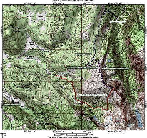
New York Mountain Summer Routes