
-
 30186 Hits
-
 82.48% Score
-
 15 Votes
|
|
Route |
|---|---|
|
|
45.86670°N / 6.98330°E |
|
|
Mixed |
|
|
A long day |
|
|
AD+, III+ |
|
|
WARNING
WARNING: This is an alpinistic, not an hiking route. Because of lenght and altitude, in order to climb it succesfully you must have have a sufficient physical and technical preparation, and a clear meteo. In case of doubt or for further information, contact the The Company of Guides at Courmayeur (www.guidecourmayeur.com) or the Fondazione Montagna Sicura (www.fondazionemontagnasicura.org)Historical Notes
1st ascent to the Pointe Whymper: Edward Whymper with Michael Croz, Christina Almer & Franz Biner, Jun. 24, 1865. The first party left Pre St. Didier (3 km. below Courmayeur!) at 1.35AM of the 24th, stopped for a rest near the Reposoir, summited at noon then returned to Courmayeur before sunset! The curious thing is that Whymper did the first ascent of the Jorasses just as a reconaissance for the imminent Aiguille Verte attempt. Less than 20 days later, Whymper and Croz made the first ascent to Matterhorn (where Croz died). 1st ascent of the main summit (Pointe Walker): Horace Walker with Melchior Anderegg, Johann Jaun and Julien Grange, Jun. 30, 1868Approach
Boccalatte-Piolti Hut (2803 m.) 30 beds, warden in July and August, tel. +39 0165 844070). For info check the SummitPost page of the hut or mail Mrs. Luciana Pandolfi - the warden - at luciana_pandolfi@yahoo.com. She takes reservations for the next summer. The hut has been restored in 2001, and it's a well managed, very pleasant place to stay, even for the Mount Blanc massif standard. However, in high summer people coming down from the Jorasses after climbing the north face or the west ridge often crowds it. Just in case, ring the warden before you go. A curiosity: Luke, the other warden, keeps this Internet blog dealing (also) with the life in the hut!
The Boccalatte Hut has now a SP page on its own:
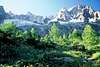
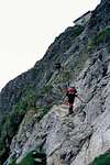
Approach (diff. EE, 3.30 h, 1200m): from Planpincieux (1600m), in Val Ferret (reachable from Courmayeur by car or in 30 minutes with the bus service), at the upper end of the village, from a huge parking serving a hotel and a restaurant, just before the "Grandes Jorasses" camping. On the opposite side of the parking, behind the restaurant, the little village church is well visible. Take the small road on the left for 100m, turn right and then walk between few houses to get to the village church. Take the trail to the left of the church (sign "Rif. Boccalatte-Piolti", marked "21" at regular intervals). The path goes through pleasant forested area (coniferous, beautiful flowers in June) then over a long grassy slope, dominated by the mass of the Grandes Jorasses. Once onto the rocky barrier below the Planpicieux Glacier, the trail (always well marked, can be followed without problems even in scarce visibility, through I would not suggest to climb up the Boccalatte in bad weather!) cross two small streams to the right (the second can be difficult after a rainy spell), and then climbs up a steep slope (some easy scramblinb, up to II°, exposed in some bit, requires care in descent) until a metal ladder over a wide chimney (2300m circa). Above, the trail goes up on a moraine on the right side of the Planpicieux Glacier, and then follows its crest until reaching the rock barrier where the hut is located (well visible from below). Climb through a trail cut into the rock and equipped with big fixed ropes (easy, some II°) until the hut.
 |  |
Route Description
Leave the hut and cross the rock "rognon" above, reaching the glacier on the opposite side (cairns, traces). Climb a snowy slope to the left of the bottle-shaped crest just above (it's called "La Bouteille") heading towards the base of the Rocher du Reposoir (3400 m.). Climb it (II/III) al the way to the top, the cross to the right traversing the "Whymper couloir" (danger of avalanche - cross rapidly and only under cold conditions! The first bit is quite tricky because of recent glacial movement, normally there's a fixed rope). You must aim at an evident dihedral/couloir on the flank of the Rocher Whymper, the long spur coming down from the Pt. Whymper of Grandes Jorasses. While this used to be often snowy, it's now almost invariably dry and easy (some IV-).
Once on the spur, you've two choices:
1) The classic route goes up a little on the Rochers Whymper, then, once at the same level with the upper glacial plateau, cross to the right, traversing the plateau towards the mixed slope directly under the Walker point. Climb this slope near the end of the Pra Sec ridge (a little right of the line of the main summit.)
or
2) Climb all the Rocher Wympher (III, a pleasant climb if there's no ice, otherwise it becomes more difficult) to the Pointe Whymper, then simply traverse the summit ridge to the Pointe Walker (the main summit).
Option number 1 is easier, but don't ever think about it if it's late, or the snow is becoming soft. In other words - do it only before sunrise and in cool weather. Be careful - the serac barrier above the plateau is still unstable!
Option number 2 is a bit more difficult technically, but far safer (and a bit more interesting too). If it's late, this is the one to use. Also, use this in descent (some abseil/rappel useful, but you can downclimb too if the rock is dry). In summer, the route up the Rocher Whymper is now the line of choice, because of the danger posed by the serac on the Jorasses plateau. In winter route n°1 can be an option but beware of avalanche risk on the final slopes to the Pt. Walker.
In descent: in these days the Grandes Jorasses normal route is more often used going down than up. Remember - it's relatively long, complex, and can be difficult to negotiate in bad weather or if you're very tired. The safest hours for a daytime cross of the Whymper couloir are a) before 10 AM or b) after sunset. Any other daytime hour is a gamble - the route is exposed to south-west, so it takes all the afternoon sun!
When crossing back from the summit of Pt. Walker, you must remember that on the little Walker-Whymper col there's an enormous cornice on the north side - stay away from the ridge if there's no track and visibility is poor!. The best strategy is to aim at the base of the little "gendarme" on the Rocher Whymper - just below the top of Pt. Whymper . Once on the Rocher, the line of descent becomes evident.
Allow 6 hours from the Boccalatte hut to the summit, and 4 hours for the trip back (but it's not unheard to have far longer descent times if conditions are bad).