

-
 15722 Hits
-
 91.14% Score
-
 34 Votes
|
|
Route |
|---|---|
|
|
46.50766°N / 12.21169°E |
|
|
Mountaineering, Scrambling |
|
|
Summer |
|
|
Most of a day |
|
|
PD+ I/II 1p III UIAA |
|
|
Overview
Punta Sorapiss Normal route
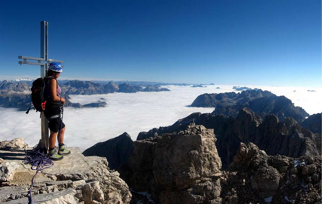
Punta Sorapìss 3205 m is a sumptuous and celebrated mountain of the Dolomites, admired and photographed by thousands of people from Cortina and Misurina. It's a superb peak, one of the most important summit in the Cadore region and among the 3000 of the Dolomites. The Normal route is a long and satisfying ascent, with a maximum difficulty of III degree UIAA (a short stretch), but on rough and sometimes exposed terrain and therefore isn't to be underestimated. This route has a rather low attendance, perhaps because it is very long and tiring. Precisely for this reason it takes place in a still authentic and satisfying context. The only “real” climbing difficulty is the chimney with a short passage of the III UIAA degree, there are many passages of I/II UIAA, a bit exposed in the last part, so you have to stay focused all the way, also in reason of the quality of the rock, not always good.
Anyway, this is one of the best Normal routes of the Dolomites a fantastic ascent to a very satisfying summit, with an amazing panorama on all the Dolomites. You will be proud to sign the summit book of this mountain (where you will find very few signatures ).
In the opinion of Antonio Berti, one of the best connoisseurs of the Dolomites, the summit of Sorapiss offers the best view of the Eastern Dolomites. And it’s really fantastic, it’s impossible to describe the beauty of this amazing sea af dolomitic mountains that you can see around you.
History
This route was climbed for the first time (as descent) by the famous Austrian alpinist Paul Grohmann with the the alpine guides Francesco Lacedelli and A. Dimai from Cortina on September 16, 1865. The team summited the peak climbing a completely different route across the Vallone del Banco and Pian della Foppa on the West side of Fòpa di Mattia. During the descent Grohmann and his guides, although they had studied well the mountain from all sides didn’t follow the same route, but descended on the current Normal route. because it was already dark and they couldn’t find an easy way. A little historical curiosity: the technique of rappelling was invented right on Sorapiss. It was the first rappel in the Dolomites! It was already dark and the team couldn't find an easy way to descent. The guide Checco Lacedelli had the brilliant idea to double the rope and pass it around a spike, recovering it by pulling on one end. This move allowed the guides and their illustrious client to reach the scree at the base of the rocks and thus continue the descent without difficulty and then get to Cortina after twenty-two hours spent on this mountain!
Getting there
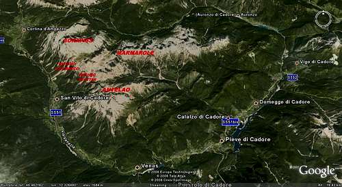
The starting point to climb Sorapiss is the village of San Vito di Cadore m. 1011, 11 km. to Cortina d'Ampezzo, the main town in the area.
Getting to San Vito di Cadore
- From Belluno: follow the road SS 51 towards North, pass Longarone and reach Pieve di Cadore; from Pieve the SS51 turns to left, getting San Vito di Cadore.
- From Bolzano: take the Brennero Motorway towards North, exit Bressanone and then follow the road SS 49 along Val Pusteria, getting to Brunico and Dobbiaco; in Dobbiaco leave the Val Pusteria road and turn to right on the road SS51 entering Val di Landro and getting to Carbonin m. 1432. At the fork road in Carbonin turn to right towards Cortina d’Ampezzo, then San Vito di Cadore.
From San Vito di Cadore take the road to the Rifugio Scotter-Palatini. After a few km you will reach the parking below the San Marco chairlift station (1220 m), where you can park your car and take the wide gravel road (n. 228) to the refuge Scotter. After a few hundred meters turn to left across a bridge over the Ru Secco. The road starts to climb with a constant slope up to the Scotter Refuge m. 1580 (50 minutes). The hut can be reached also by car, but the road is open only from 6.30 p.m. to 7.30 a.m. From June to September, a shuttle service is available by reservation and call with departure from the Sunbar hut from 8.30 to 18.00. Alternatively you can take advantage of the chair lift.
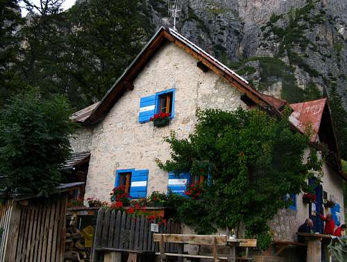
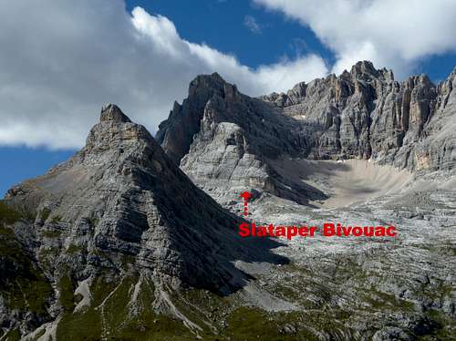
From the Rifugio Scotter ignore the path to the Rifugio Galassi on the right and turn left onto the good path to Rifugio San Marco. The path rises along the wood, reaching in half an hour by pleasant walking the lovely Rifugio San Marco 1850 m, situated between the groups of Sorapiss, Antelao and West Marmarole – all included in the Unesco World Eritage list. The hut is located on a magnificent and panoramic place on Valle del Boite, the gigantic Antelao, Monte Pelmo and Croda da Lago-Rocchette Group. From here, if the weather is fine, you can enjoy a terrific sunrise over Antelao and Pelmo. Being the route very long, to stay overnight at the hut can be a very good option. Another possibility is to stay overnight at the Bivacco Slataper, from where the ascent is decidedly shorter.
|
|
|---|


Route report
Punta Sorapìss Normal route - UIAA scale
Summit altitude: 3205 m
Difficulty: PD+, III max (a short move) - UIAA scale
Orientation: South
Difference in level: 1625 m from Rifugio Scotter, 1382 m from Rifugio San Marco, 605 m from Bivacco Slataper
Starting point: Rifugio Scotter, Rifugio San Marco, Bivacco Slataper
First ascent: Paul Grohmann with F. Lacedelli, A. Dimai on September 16, 1865
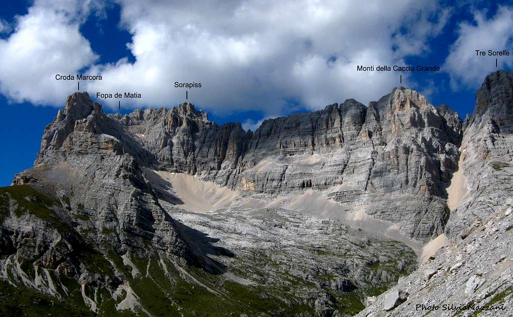
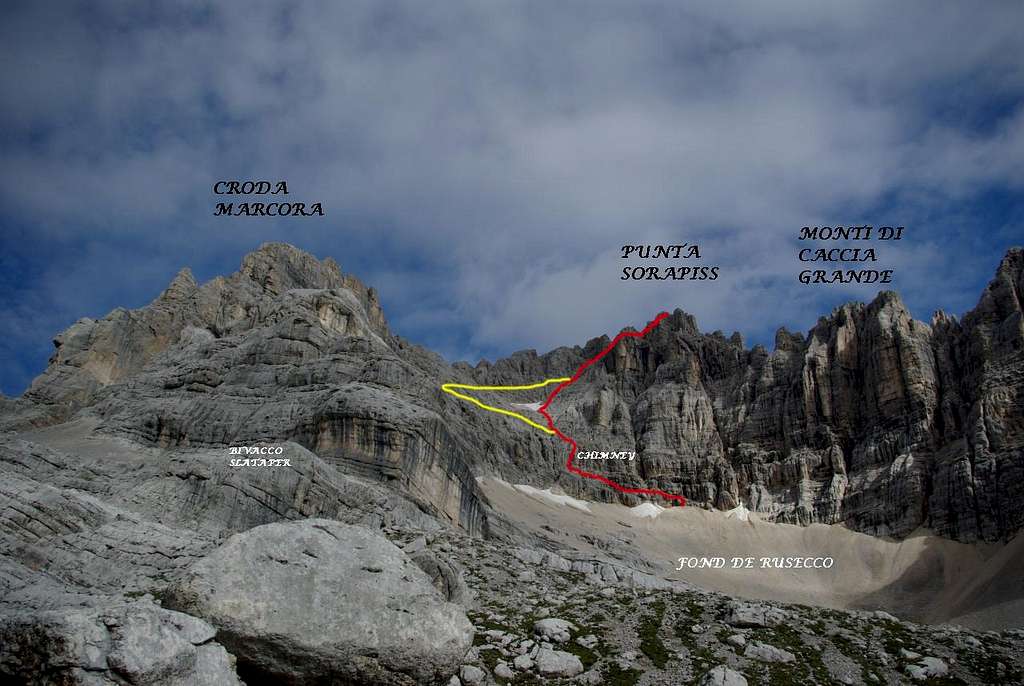
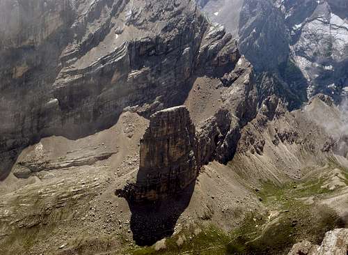
Beautiful and highly satisfactory route to summit a great mountain, anyhow long and tiring especially for those who climb it directly without overnight accommodation. The starting chimney opposes a short move of III grade, then the route rises to the top across ledges and easy rock climbing stretches, sometimes exposed and requiring a firm foot. The route is well marked by cairns and red stamps. The initial part of the route is common to the three mountains that form this crown of peaks, Croda Marcora (on the left), Fope de Matia (in the middle) and Sorapiss (on the right)
From Rifugio San Marco to the start of the climb
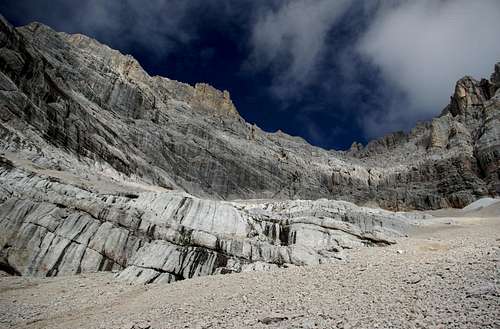
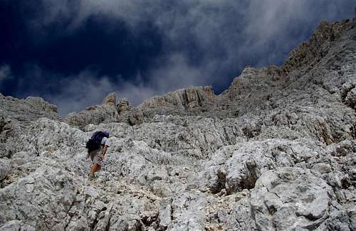
From the Refuge San Marco take the good path n. 226 which takes place at first along a deep gully, then on a slope rising towards Forcella Grande 2255 m, a wide saddle between Cima Bel Prà on the right-hand side and Cima Tajola on the left. On the saddle there is a junction. Here it appears a gorgeous view of the Torre dei Sabbioni, the Bel Pra group and the Sorapiss group. At the junction on the saddle take the main path n. 246 on the left following the signpost to the Bivacco Slataper. The path climb the scree below Punta dei Ross on the left of the valley Fond de Rusecco. Follow the bottom of the valley, then the rocky slabs leading to a grassy crest, after which you reah the rockybslabs situated below the Bivacco Slataper. Without reaching the bivouac, follow the path to the right, rising up with several hairpins on the strenuous scree slope that will take you to the rocks at the beginning of the route at about 2800 m of altitude (red arrow).
variant: if you stay overnight at the Slataper bivouac, reach the attack to the right of the scree
The climb
The route begins with the climb of a short wall (slippery when wet), II-, that takes you on a ledge to be followed in the left direction. A short 20 m climb in the right direction leads to another ledge to be followed again in the left direction for about 100 meters (an exposed move). The ledge is good but requires caution. Reach the bottom of a couloir under the direction of the left one of two obvious chimneys above.
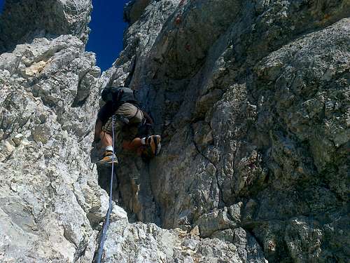
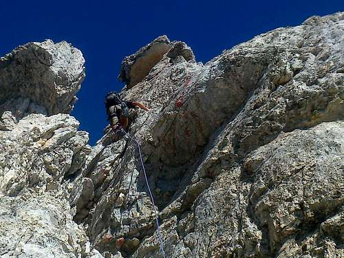
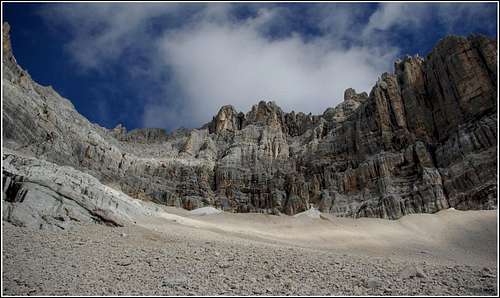
Climb the couloir and reach the base of the left chimney. Climb the 15 m long chimney with a smooth wall on the right and a stuck boulder in its upper part (II, one move of III, 1 peg after the block, 2 pegs at the exit for the descent). This is the crux of the route. At the exit of the chimney there is a notch, from where you climb towards the right by steps up to the "cengia mediana " (middle ledge) located below the Giaron Alto, a gravel basin in the middle of the wall. Follow this ledge to the left in the direction of Croda Marcora (red stamps). After about 50 meters, beyond a first couloir, near two cairns it starts a slope of inclined rocks at about 2920 m. This one is the original Grohmann descent route. This shortcut to the long middle ledge allows you to avoid the long trip that the ledge makes, at first by heading towards the base of the Croda Marcora, then returning to the right to reach the base of the Sorapiss. The marked path goes on towards the ledge towards Croda Marcora, but actually it’s better to turn right and follow the Grohmann original route.

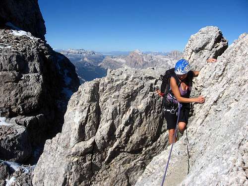
There are some red stamps and cairns also along the variant, it’s just a fun climb no more than the UIAA I/I+ degree. Climb the easy rocks a little to the right, heading towards a yellow tower. Higher up, the variant route intersects the couloir that descends between the Fopa di Matia and Punta Sorapiss. Go up the couloir on the right side, always leaving the Giaron Alto basin on the left. The shortcut closes at the end of the median ledge above, marked by obvious red stamps, near an inclined ramp at 3075 m. You are now below the summit towers. Climb the ramp, then take a short scree-gully rising to a crest (red stamps). Head to right, take a ledge to a couloir and climb it. Take a ledge to the right and near a big cairn take a ridge, climb it for about 10 m, then traverse right to bypass the ridge and follow another ledge to a narrow couloir. Descend it, then climb up another narrow couloir leading to a wide couloir below the summit. Climb the couloir on the left along a chimney with another exposed passage (II, 1 peg), then exit right on a ledge (2 pegs) leading to an easy couloir reaching the summit crest and the summit cross on a flat terrace.

the chimney
Descent route - Same route for the descent until the belay above the III grade chimney from where you have to rappel to the base (exactly 30 m). Then follow the ledges until the scree slope (very good for the descent ) and take the same path of the ascent to Forcella Grande, Rifugio San Marco and Rifugio Scotter-Palatini ( 3 hours ).

out of the chimney

the scree slope

the Bel Pra group
Essential gear
Helmet, harness, a 40 m rope is enough, some slings and carabiners
Red Tape
No fees no permits required
Summit views
 |
|---|
 Cortina basin |
 Misurina |
 Torre dei Sabbioni |
 Tofane |
 Cristallo group |
 Croda Rossa group |
When to climb
Summertime
Huts
- Rifugio San Marco 1823 m
Situation: Col de chi da Os
Owner: CAI – Club Alpino Italiano Sez. Venezia
Guardian: Ossi Marino and family - San Vito di Cadore BL
Open: from 20 of June to 20 of September
Size: 37 persons
Winter shelter: yes
Phone: +39 0436 9444 - Mobile: +39 339 3802505 /+39 335 8165066
e-mail info@rifugiosanmarco.com
- Rifugio Scotter-Palatini 1580 m Situation: Pian dello Scotter
Guardian: Fam. Palatini
Open: from 20/6 to 20/9 (summer) and from 8/12 to 15/3 (winter)
Size: 20 persons
Winter shelter: no
Phone +39 0436 99035
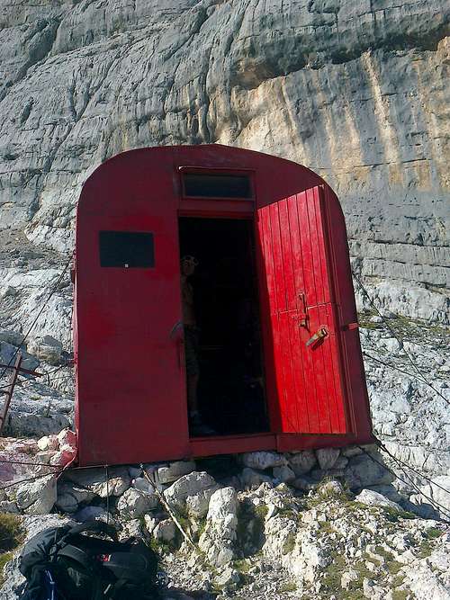
- Bivacco Slataper 2600 m
Situation: Fond de Risecco
unguarded, always open
Size: 3 persons
Meteo and Webcams

ARPAV DOLOMITI METEO Phone +390436780007 fax +390436780008 CENTRO VALANGHE DI ARABBA Phone +390436755711 fax 043679319 e-mail cva@arpa.veneto.it
Guidebooks and maps
G. Buscaini, S. Metzeltin - Dolomiti. Il grande libro delle vie normali – Zanichelli Editore
A. Berti – Dolomiti Orientali vol I – CAI TCI
H. Kammerer, R. Goedeke – I 3000 delle Dolomiti – Tappeiner
L. Visentini - Antelao, Sorapiss e Marmarole – Athesia
Tabacco 1:25000
03 Cortina d’Ampezzo e Dolomiti Ampezzane