-
 41376 Hits
-
 94.63% Score
-
 48 Votes
|
|
Area/Range |
|---|---|
|
|
46.50570°N / 12.21890°E |
|
|
Hiking, Trad Climbing, Big Wall, Via Ferrata |
|
|
Spring, Summer |
|
|
10515 ft / 3205 m |
|
|
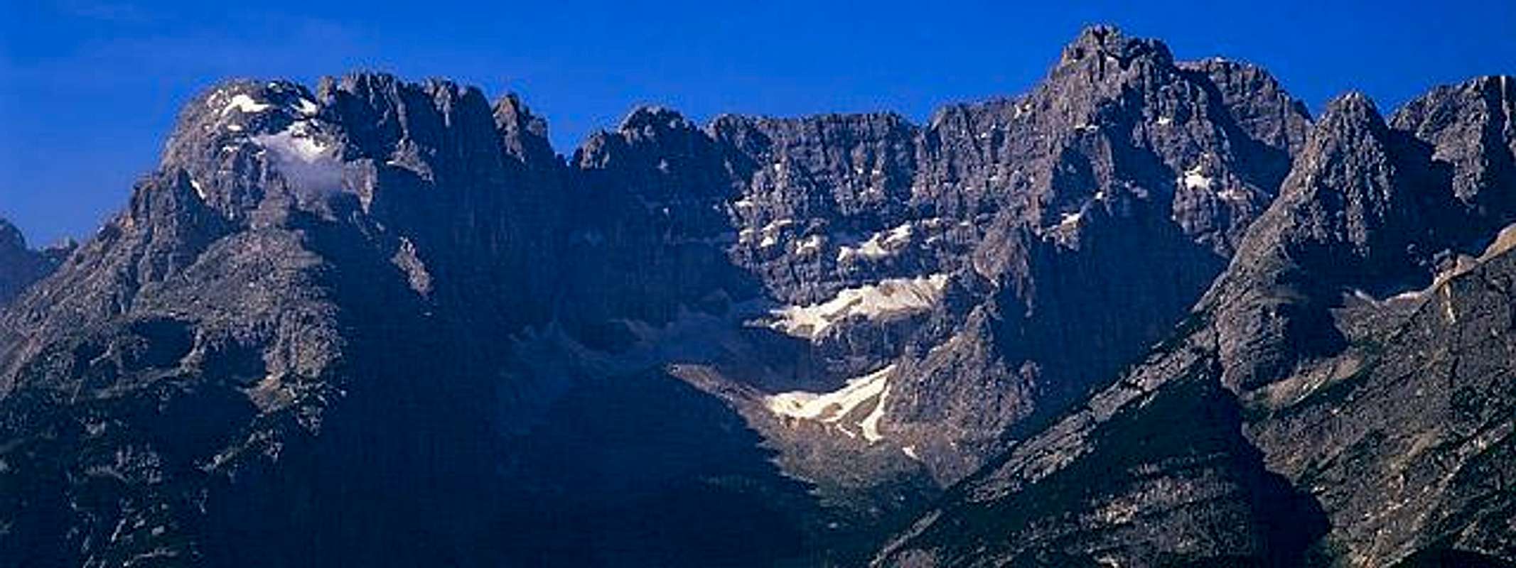
Overview
Sorapìss .. its name sounds well known to all Cortina tourists,
 . . |
 |
 |
| nobody can forget the huge red wall that looms, arriving in San Vito di Cadore, while running along the Alemagna road from south | nobody can do but giving frequent glances to the high huge wall that closes to the East the Cortina basin, wherever you are there | nobody can do but admire the fantastic high and wide mountain that closes the view to south when at Misurina lake |
...but, despite that all, together with its neighbour Antelao it is one of the less frequented mountains in the area and very rarely climbed.
| Sorapìss (not Soràpiss) means "Over the waterfall" it is a dialectal composite name : Sòra (sopra) = Over , Pìss (cascata) = waterfall) and indicates one of the biggest dolomite mountains. |
 like in a dream ... |
It is, at the same time, a summit, a ridge, a range, a group standing up along a ridge that stretches over many miles with a big difference in elevation from the surrounding valleys |
some geographic info ...
Its borders are :
- to the West the Cortina basin - the difference in elevation is about 2100m
- to the North the road leading from Cortina to Acquabona (Val d'Ansiei) passing through the Passo Tre Croci - the difference in elevation is between 1450 (from Passo Tre Croci) and 2000m
- to the East the Val di San Vito, dividing Sorapìss from Marmarole group - the difference in elevation is between only 1000 (Forcella Grande) and 2000m
- to the South the Val Ru Secco, dividing the Sorapìss from its giant neighbour: the Antelao, the difference in elevation from this side is between 1500m and 2200m
![]()
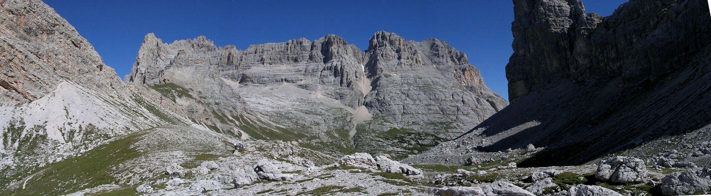
Its orographical structure can be defined as composed by a central main ridge (the monti della Caccia Grande ridge) hosting the main summit (Punta di Sorapiss - 3205m)
from its western limit (Fopa di Mattia - 3155m) a big ridge goes toward south, this is the Sorapìss side that all can see from Cortina and that hides the real main summit (on this wall there was a small glacier, now only some snow slopes can be seen till early july)
a little more toward west, after a high pass (valico sopra la Cengia del Banco) another big ridge goes toward north hosting, in its lower part, the ski area called Faloria.
Its northern side contains 3 basins : from west - Tonde de Sorapìss where the most important hike runs across
- the western glacier
- the central and the eastern glaciers (very reduced in the last years) that lie below the highest wall of the mountain.
![]()
locally it is known as made by 3 main sections
Banco spur
Main ridge
Ampezzo ridge
in this section of Cortina page you can find some more pics
Contrafforte del Banco - Banco Spur
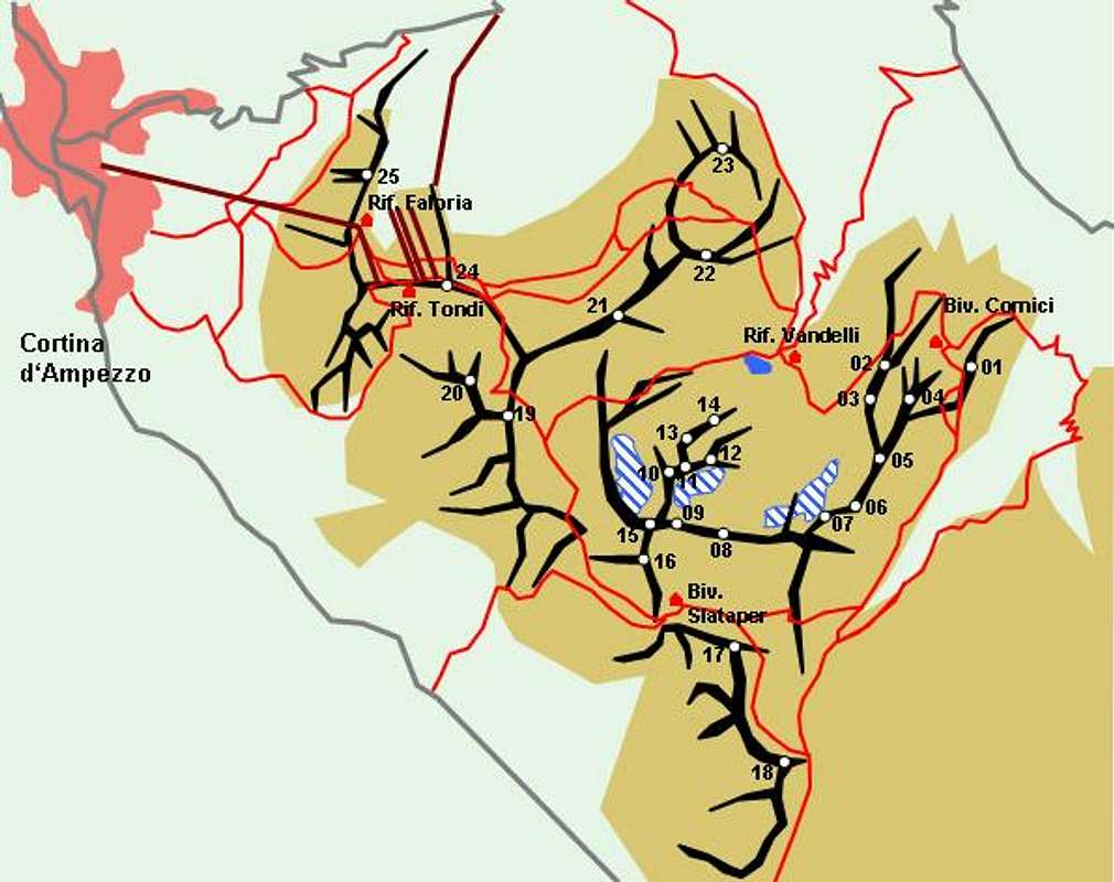
here a map from Kompass 1:25000 "Cortina d'Ampezzo - Dolomiti Ampezzane"
01 - Croda del Banco (2150m)
02 - Croda del Fogo (2567m)
03 - Corno Sorelle (2660m)
04 - Torri di Busa (2638-2627m)
05 - Cime di Valbona (2899-2912m)
06 - Torrione Sortsch (2982m)
07 - Le Tre Sorelle (3005-2999m)
Main ridge
here and here 2 maps from Kompass 1:25000 "Cortina d'Ampezzo - Dolomiti Ampezzane"
08 - Monti della Caccia Grande (3023-3002-2997-3004m)
09 - Punta di Sorapiss (3205m)
10 - Cima di Falkner (3053m)
11 - Cima Emmy (2860m)
12 - Gusela del Rifugio (2547m)
13 - Zurlon (2720m)
14 - Dito di Dio (2603m)
15 - Fopa di Mattia (3155m)
16 - Croda Marcora (3154m)
17 - Punta dei Ross (2460m)
18 - Punta Taiola (2485m)
![]()
![]()
Contrafforte Ampezzano - Ampezzo ridge
here a map from Kompass 1:25000 "Cortina d'Ampezzo - Dolomiti Ampezzane"
19 - Punta Nera (2847m)
20 - Croda Rota (2670m)
21 - La Cesta (2768m)
22 - Cime Ciadin del Laudo (2670-2640-2608m)
23 - Cime di Marcuoira (2428-2422-2288m)
24 - Monte Ciasa Dio (2362m)
25 - Monte Faloria (2034m)
![]()
![]()
Getting There
3 main different ways to get here :
from Veneto
Motorway from Venezia (Venice) to Ponte nelle Alpi - then follow to Cortina (route 51 - Alemagna)
from Sud Tirol
from Bressanone (Brixen) follow for Val Pusteria (Pustertal) till Dobbiaco (Toblach) then Passo Cimabanche route till Cortina
from Trentino
from Val di Fassa - Passo Pordoi - Arabba - Passo Falzarego - Cortina
the 4th approach, the less frequented one is from Val d'Ansiei,
along the road going from Auronzo toward Passo Tre Croci : the eastern, wild, approach to the mountain ...
Auronzo can be reached from Tai di Cadore (along the Alemagna road coming from Belluno) turning toward east and driving around the Antelao and Marmarole groups.
Accomodations
together with Antelao and Marmarole this is the only mountain, in Cortina area, requiring to spend night in Refuges to make a long hike or a climb.
So, apart the Faloria area (Rif. Faloria - 2123 m) , that can be reached using a cableway starting directly from Cortina, there are 2 refuges and 2 bivouacs.
Rifugio Vandelli(1928 m) , on the northern side, starting points to get it are - Passo Tre Croci, on the road that leads from Cortina to Misurina, (2 hours of fine walk on a good and well marked path, with some short ladders and fixed ropes)
- Faloria, along a fine hike crossing under the northern slopes of Punta Nera and crossing the Forcella del Cadin or the Sella di Punta Nera (more difficult)
Rifugio S.Marco (1823 m) , on the southern side, starting point is a good car parking area at the end of a narrow road starting from San Vito (marks) wherefrom in about half an hour you can get the nice site
Bivacco Slataper (2600 m) , on the ridge coming down toward SE from the Croda Marcora, apart the approach from Faloria along the Cengia del Banco (ferrata Berti) , can be reached also - starting from Rif. San Marco, crossing the Forcella Alta with an easy hike (3 hours)
- from Dogana Vecchia (near Campo di Sotto - reference point the ski jump) along a tiring path that leads to the Cengia del Banco where it crosses the Ferrata Berti (5 hours)
- from Faloria, along the Tonde de Sorapiss to gain the Ferrata Berti
Bivacco Comici (2050 m) placed in a wild site called "Busa del Banco" under the walls of Torri della Busa and Croda del Banco, good destination for a fine hike; can be reached from : - Rifugio Vandelli, along the ferrata Vandelli (3-4 hours)
- Palus San Marco (val d'Ansiei road) following the marks for Forcella Grande and along a not easy path requiring some bearings knowledge and a good map (3-4 hours)
some hiking info
No real walk-up routes with the exception of the paths in Faloria range
Even getting the rifugio Vandelli (the most frequented, in a fairy tale environment with its green lake) requires a walk along a very fine path that somewhere hosts short pieces of (easy) ferrata![]()
![]()
![]()
Some fine hiking routes, none really easy and all requesting good training and fit, run all round the "big" Sorapìss : the complete "ring" of Sorapiss requires at least a 2 days trip and takes place on a complex, high and somewhere very exposed system of ledges , along the 3 main ferrate of the group : Berti, Minazio and Vandelli, joining the 3 main accomodations (?) you can find here
Of course the "ring" has some escape routes that can be used also to approach the bivouacs (Slataper and Comici).![]()
![]()
![]()
![]()
![]()
The hike to Rifugio San Marco (in the south side) often ends there, because the hike to Forcella Grande (the high saddle between Sorapiss and Marmarole group) is really tiring, along very steep earthy slopes that become very slippery (and dangerous) when wet
(I happen to think that having a pair of crampons it would have been better), but if the path is dry and legs are good you can start a wonderful trip that leads you, from the Forcella Grande to the opposite side, till the Val d'Ansiei, running along the bottom of a very fine valley having, on your left the high wall of Monti della Caccia Grande and Tre Sorelle and on your right the wild and forgotten walls of the Marmarole.
![]()
some climbing info
Of course, on a so wide mountain full of summits and high walls, a lot of rock rotes have been opened till the '40 :
here, on the N wall of Tre Sorelle, Emilio Comici opened the first 6th degree italian route (1929)
the whole N wall (the one that hangs over the Rifugio Vandelli), with its almost 1000m drop hosts some old fashion very "alpinistic" routes, very rarely climbed so that the rock not always is good and clean.
Minor summits, faster to be approached (like the Dito di Dio and Zurlon) are so lucky to have, sometimes, some rope team upon their hard and difficult routes ...![]()
The main summits (Punta Sorapiss, Fopa di Mattia and Croda Marcora) can be got along some middle difficulty routes (the hardest one is of IV UIAA but I think that very few people have climbed them ...
The only one sometimes climbed is the normal route from South, a long, tiring and not fine climb with a short (20-25m) chimney that. with its difficulty (III UIAA), closes the route to hikers.
In a fantastic, hot, perfect day of August we were 6 climbers in the whole high ridge (all on the main summit) but the 3 people we met, soldiers of local alpine troop in training, told us that it was an exceptional event to be so many !
This is the "shortest" route to the summit and can be done in 1 day starting and coming back to Cortina, a road starting fro San Vito di Cadore leads you about 150 m (in elevation) under the Rifugio San Marco, so that you have only to go on for less than 1600 m of difference in elevation.
I hope someone will contradict me posting the description of some routes, but I must say, as for my feeling, that this is a "forgotten" mountain : too tiring for modern climbing, too hard for beginners, fascinating only for those ones who want to find quiet, solitude, "ancient" environments, wildness.
![]()
![]()
![]()
Camping
3 very confortable campings in Campo di Sotto (4 km south of Cortina) and one in Fiames (north of Cortina on the route to Cimabanche pass)
These are the best bases to spend confortable weeks in summer, just remember only to start before 9 o'clock in the morning if you must cross Cortina by car (strong traffic in august )
When To Climb
summer, from june to september
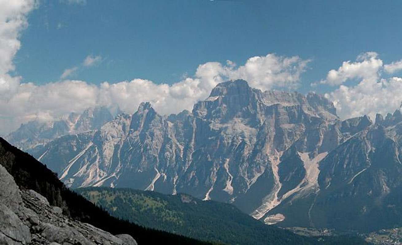
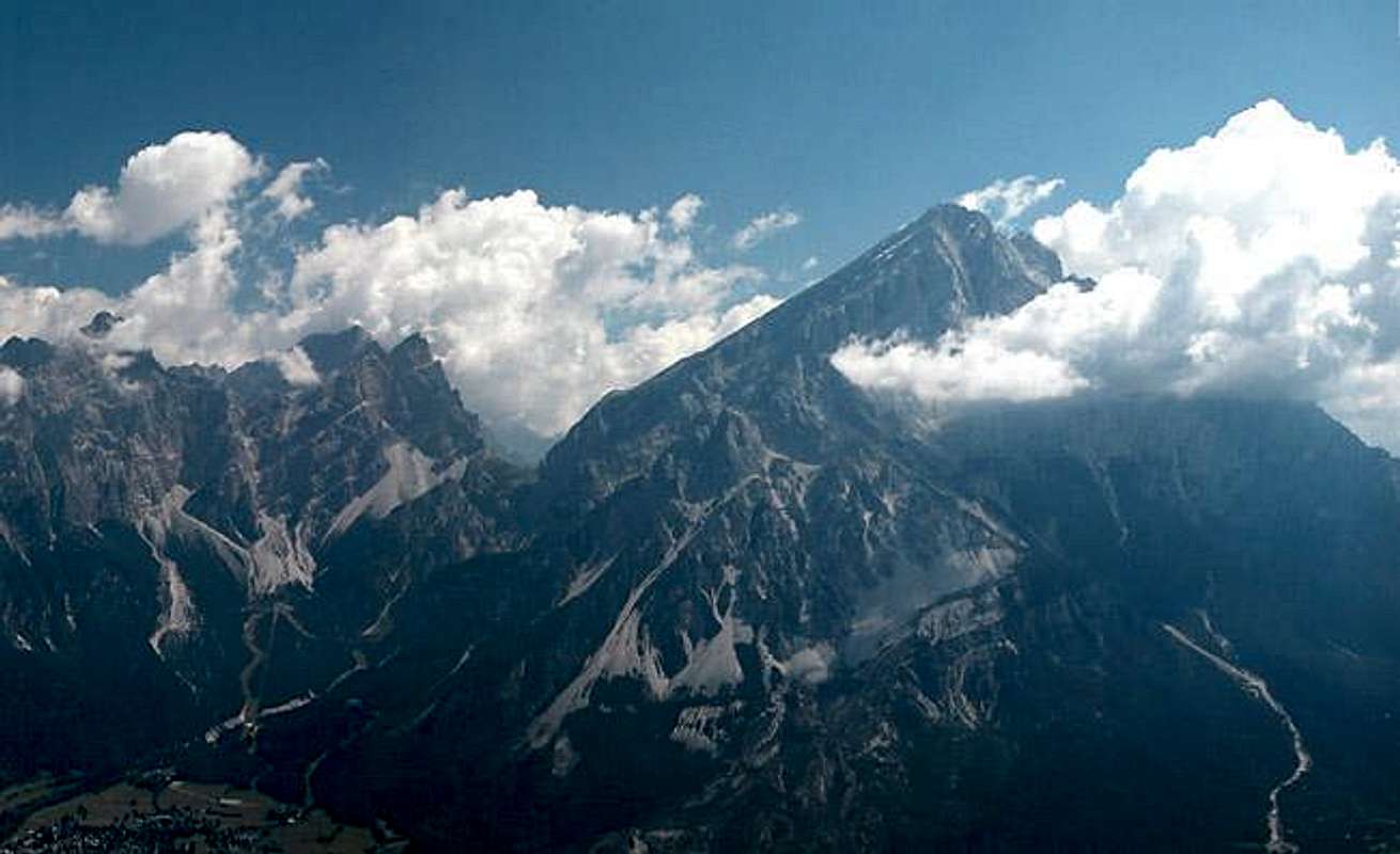
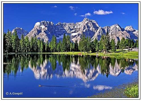
Panoramic view of Sorapiss & Antelao
The eastern Dolomiti d'Ampezzo as seen during the ascent to Forcella Val d'Arcia. Cristallo, Sorapiss, Cima Bel Pra and Antelao![]()
![]()
by Gangolf Haub
Red Tape
no fees no restrictions
External Links
- Ferrate
a good page, in italian language but with easy to understand schemes, about the "Ring of Sorapìss" - the Ring of Sorapiss
in English, short text, just meaning characteristics
- Ferrate