
|
|
Route |
|---|---|
|
|
44.12273°N / 113.778°W |
|
|
Mountaineering |
|
|
Summer |
|
|
One to two days |
|
|
R |
|
|
5.8 (YDS) |
|
|
13 |
|
|
III |
|
|
Overview
For anyone climbing the standard route on Mount Borah, the North face of Sacajawea is an imposing sight and impossible to miss. The North Face Direct climbs a fairly straight line of run-out rock pitches up the center of the face.Rock fall and very limited pro make this route hard to recommend.
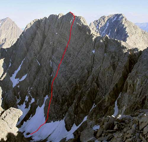 Sacajawea, North face Direct cuts a fairly straight line up the sweeping face.
 Getting There
From U.S. Hwy 93, 46 miles north of Arco (32 miles southof Challis), follow FS Road 116 northeast over Double springs
Pass for 10 miles to the turnoff of FS Road 117. Look for the Horse Haven Pass sign. Follow 11 7 over Horse heaven Pass for 6 miles to the junction with FS Road 118. Follow 118 up the West Fork road for
4.5 miles to its junction with FS Road 267. Follow 267 for 2.5
miles up the West Fork Pahsimeroi River to the end of the
road.
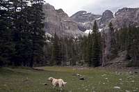 Meadows on the approach.
The approach is a moderate but very pretty 3.5-mile hike that gains just about 2,000 feet. From the end of the road, head due west; you’ll hike right between the creek and the makeshift toilet. Stay on the wide ridge keeping the creek to your left. The brush and trees are pretty sparse all the way up to the first big meadow at 9,000’ where you leave the ridge for more open country. You’ll get a good view of the mountain and you can either follow the meadows or the creek all the way to the upper cirque.
Route Description
The route starts high in the cirque where the rock cuts a V into the snowfield From there it follows 13 pitches in a fairly straight line all the way to the summit ridge and about 80’ below the actual summit. There isn’t any obvious crack system or line so route finding isn’t much of an issue. We used a 70 meter rope and probably could have stretched it out in 11 pitches but good belay anchors were not a thing to pass by for a few extra meters of climbing. The pitches ranged from 5.5 R to 5.8 R. on mostly great limestone holds.
pitches 4 and 5 are class 4 scrambling.
 Kevin belays the third pitch Kevin belays the third pitch |  Hangin' loose on pitch 8 Hangin' loose on pitch 8 | 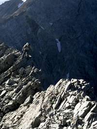 Kevin on the summit ridge at the top of the route. Kevin on the summit ridge at the top of the route. |
The descent
The DescentDescend about 1,000’ down a wide scree chute to bypass tedious ridgeline cliffs on the ridge between Sacajawea and Mount Idaho. Once past the cliffs and on the wide saddle, descend a nose of easy scree into the Merriam basin. Hike to the Merriam lake outlet and follow the trail back down to the West fork road.
 Upper Merriam lake. Lower Merriam Lake and the trailhead are just beyond the shadowed scree mounds at the end of the lake.
 Gear
Helmet! A set of small cams to number 2 and a set wired nuts. On average we were able to place 3 to 5 pieces per pitch. Crampons and axe were useful but not worth carrying up the route. We pitched them down the snowfield and returned the following day to retrieve them. Bivy gear was useful during brief rain and snow showers.Links
Lost River Ranger Districtother North face routs
Broken Wings
Gold Digger