
-
 6858 Hits
-
 78.27% Score
-
 9 Votes
|
|
Route |
|---|---|
|
|
39.41166°N / 105.21366°W |
|
|
Hiking |
|
|
Spring, Summer, Fall, Winter |
|
|
Half a day |
|
|
Class II to III - depending on route selection |
|
|
Getting there
Travel South on US 285 - west bound (Hampden Av. within city limits)
14.5 Miles to Foxton Road (Kennedy Gulch)
Take the exit and travel under the highway due south 8.2 Miles
Once at Platte River Rd (RD 96 = valley bottom of North Fork South Platte) turn left and travel along the waterfalls and rapids of the North Fork.
Cross the bridge at the confluence of North Fork South Platte River and South Platte River.
About 0.5 mile after the bridge you will see a big parking lot and a wooden bridge crossing the South Platte River to the right. This marks the trailhead for the Colorado Trail - which also serves as trailhead for Raleigh Peak.
Route Description


!!! Mytopo map (link from this site) is not showing the accurate location of the Colorado Trail - the trail does not start at the (ghost town) of South Platte, it actually starts right across the point where the Colorado Trail coming from Waterton Canyon meets the Platte River Rd (south of confluence North Fork South Platte with South Platte).
Most of the way it is an easy Class I hike along the Colorado Trail and further on along an abandoned dirt road.
Cross the bridge over the South Platte River, turn to you right and walk underneath the bridge.
Soon the Colorado Trail starts to climb through conifer forest to the ridge dividing the Spring Creek Valley from the valleys of smaller creeks heading north to join the North Fork South Platte.
You will gain quickly more than 800 feet in altitude.
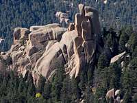
The trail starts to level out after about a mile and you enter the ghostlike landscape left behind by the Buffalo Creek Fire. The jagged twin summit of Raleigh Peak raises to the right, Long Scraggy Peak is to your left across the burnt valley of Spring Creek.
After hiking an estimated ¾ of a mile through this scorched land you will pass a yellow, rusted metal sign saying “No Motor Vehicles Allowed” to your right.
Right at this sign an abandoned dirt road crosses the Colorado Trail.
At this point the dirt road resembles more a very shallow ditch filled with burnt tree trunks and branches than a road, but the roadbed is clearly distinguishable after hiking up the road for a couple minutes.
Leave the Colorado Trail at the sign, turn to your left and follow the dirt road uphill. It offers a more straight forward approach to Raleigh Peak than the Colorado Trail. The road is unusable for vehicles as it is cluttered all the way to Raleigh Peak with tree trunks.
The dirt road follows most the time the crest of the ridge and offers sweeping views especially to the south (Devil’s Head, Long Scraggy Peak, Pike’s Peak) – Raleigh Peak is straight ahead.
Eventually, the dirt road circles around a side valley of Spring Creek north of Raleigh Peak – the two summits are now clearly distinguishable. At this point you have left Mordor again and hike through light conifer forest.
When you reach the upper end of the side valley, the dirt road starts to descend to eventually drop down to Ramona Gulch.
This point is again marked by a yellow, rusted sign identical to the one mentioned before (there are several other ones along the way).
Leave the road to your left and start hiking in direction of Raleigh Peak.
West and East Summit are of strikingly different character.
WEST SUMMIT:
The North Face of the West Summit – the higher of both summits – is forested almost all the way up to the top.
Head to the right side of the summit block, if you are lucky you will find a faint climbers trail which will lead you through a forested boulder field to the most western edge of the West Summit. But even without the trail you can easily bushwhack your way up to the summit ridge.
The summit ridge consists of two or three rows of spines – some can be easily climbed, others would require Class V moves. The cracks separating these rows of spines offer some fun opportunities for exploration – as long as you are skinny as a stick like me.
The highest spine raises next to the saddle between West and East Summmit (Class IV - V).
Sit up there and enjoy the views of Cathedral Spires and Long Scraggy Peak in the near and of Mount Evans, Pikes Peak and Lost Creek Wilderness in the farer distance.
If you are lucky you find the summit registry close by in what was once a large plastic salt shaker. A container which is unfortunately not designed to keep water out as registry was soaked when I found it. Perhaps a charitable soul can deposit a container up there better apt to keep the registry dry.
EAST SUMMIT
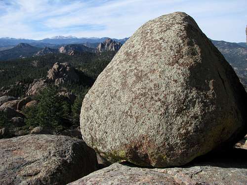
The East Summit is basically one huge boulder, with vertical cliffs on its East and South side. Trees stop growing way further down than at West Summit.
The saddle between both summits can be reached by a Class III down climb from the West Summit. Otherwise just bushwhack through the forest below the summit block and try to find the ravine which is separating both summits.
Climb up the ravine (easy Class II) and proceed on the Eastern Summit block itself after you passed the cliffs on your left. Getting up to the summit boulder requires one or two Class III moves.
While the highest spine of the West Summit has barely space for one person, a whole school class could have a pick nick on the East Summit. The views will make your head spin.
This is a great place to watch raptors…a falcon flew basically right over my head
Essential Gear

sturdy hiking boots will suffice - be protected against the sun especially during the summer and bring lots of water