
-
 11248 Hits
-
 74.92% Score
-
 5 Votes
|
|
Route |
|---|---|
|
|
36.93190°N / 102.9977°W |
|
|
Hike |
|
|
Less than two hours |
|
|
Class 1 (Walk-Up) |
|
|
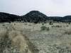
Approach
The Nature Conservancy has constructed a parking lot and trailhead for the Black Mesa Preserve. All hikes of Black Mesa should begin at this point in order to minimize damage to the area.
Route Description
The trail begins at the northeast end of the mesa and meanders around its base before ascending around 500 ft to the top. It then continues for a short distance to the summit marker in the midst of what seems to be a vast plain. All in all, the well-marked route encompasses 8.4 miles round-trip and only about 800 vertical feet. The mesa top used to be difficult to navigate, however, signs marking either "HIGHPOINT" or "TRAIL HEAD" (depending on direction of travel) lead the way.
 |  |  |
Essential Gear
None required
Miscellaneous Info
If you have information about this route that doesn't pertain to any of the other sections, please add it here.