
|
|
Route |
|---|---|
|
|
40.77750°N / 107.2495°W |
|
|
Hiking, Mountaineering |
|
|
Summer |
|
|
One to two days |
|
|
Overview
Like most other trails and routes in the Elkhead Mountains, this one is little used, and solitude is almost assured even on popular holiday weekends. The three trails in the area do exist, but since they are used much more by elk and other wildlife, than hikers, they are crisscrossed with many game trails and luck and paying close attention to where you are is essential when approaching Bears Ears from the south.The southern route is quite a bit longer than the northern route, but has the advantage that the trailhead can be reached almost a month earlier in the year. It is also a nice backpacking area and the terrain is fairly wild, but not rugged.
Two trails begin at the North Fork Elkhead Trailhead. Trail 1145 is the longer of the two. It is in fair condition, but is crossed by many game trails, so navigation skills are essential. Trail 1146 follows North Fork Elkhead River itself, so should be fairly easy to navigate. I couldn’t find the very beginning of the trail, and haven’t hiked it, though I have viewed it from above. Since Trail 1145 is the one we hiked, it is the one that will be discussed on this page.
 Bears Ears from Trail 1145
Navigational Warning
Warning: None of the maps available show the roads (and there are no trails) on Bears Ears accurately, and route is no exception. The closest one that bears resemblance to reality is the Forest Service Map-Routt National Forest, but even that one doesn't show all the roads, while showing others that have long faded away or that don't exist. The USGS maps do not show the last road to the trailhead at all. The USGS maps don’t show some of the other roads in the area as well, but seem to show roads and trails that don’t exist; at least not any more. The Northwest Ear as viewed from the west.
Getting There
Directions to the trailhead will be brief because you had better have a Routt National Forest map in hand. Don’t try finding the trail without it.My route from Craig, followed Highway 40 east to County Road 29 (CR29), turned north past Elkhead Reservoir, right on CR 18, left on CR 76 to a major junction (there are several minor junctions before this, and at one unmarked one, I took a short detour left at a ranch).
A sign will say the main road right is private. Turn left on the 4wd road and drive it to the trailhead. The road is rutted and rough in places, and stay off it when it is wet. It should open in mid-June in most years, but sometimes later. 4wd is definitely required for the last few miles, but you can walk it if you have a car. The trailhead is at an old stock pond dam and a trail sign.
If coming from Hayden, you can head directly north on CR 76 and stay on it all the way to the junction with the private road mentioned above. This will be the least complicated route for most people.
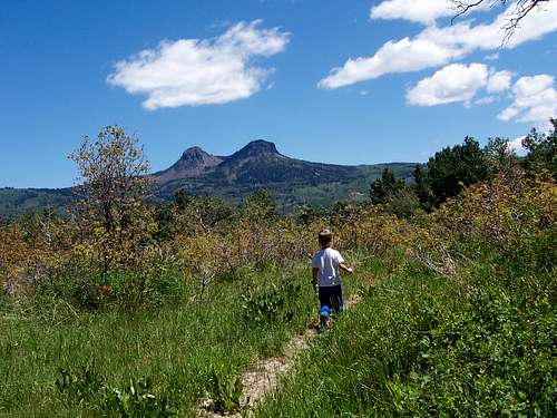
 We caught this ek splashing and playing in the first pond while hiking Trail 1145.
Route Description
From the trailhead, locate the sign and trail to the north and across an old dam. Follow the trail up the hill. It is easy to follow until reaching an old stock pond, at which point the trail is crossed by several game trails. We witnessed an elk splashing and playing in the pond, so be quiet when approaching.The correct path from the stock pond is the one marked with the post. These post are how this trail is marked in several locations.
Follow the trail up and over the hill. Once again the main path is confused by game trails. If the trail you choose on begins to get brushy and faded, try the another one. Remember that until Sawmill Creek is reached, the general trend in the trail is a northerly direction.
At one point after cresting the hill, the main trail appears to head right, but it really heads left. Try to follow the most used trail. Just before dropping to a creek, and at an old beaver pod the trail gets confusing again, so remember this spot for the return trip. Luckily just before crossing the creek (it was flowing in June 2006, but it may dry up in late summer?), a sign informs you that you are still on trail 1145. Follow the trail up the hill and up a shallow drainage.
One again the trail is crossed by a well used game trail, so look for post marking the correct trail. After cresting the next hill, take special note as to where you are and what trail you are on, because this area is more confusing on the return000 trip.
The trail drops down to Sawmill Creek, which appears to flow year round (?). Just after crossing the creek, a very old and faded sign states you are on the “Sawmill Creek Trail”. The trail fades a bit in the few places, but navigation is easy because the trail generally follows the north side of Sawmill Creek.
The trail reaches Trail 1144, the “Bears Ears Trail” after four miles from the trailhead. Turn right (east) here and follow the Bears Ears Trail towards the Bears Ears. I hiked this trail in the summer of 2005, and it to be fairly easy to follow, but with many fallen logs in places. Rumor has it that this trail is sometimes cleared by an outfitter during the elk hunting season, so it may be easier to follow (but more dangerous) in the fall.
It appears to be about six miles to the base of the Bears Ears from the junction with Trail 1145. Once near the Bears Ears, you could circle around to the North Route that we used to climb the higher of the two peaks in July 2005, but you may find another route if you look around?
To climb this route to the summit should take two days, but there are other options as well. See the next section.
 The trail comes and goes and disappears briefly in places, so keep a sharp eye out for it, and always pay attention to where you are.
Other Options
From the same trailhead, you could east down the gully and to the North Fork Elkhead River itself. This would be a shorter route than going up Trail 1145. I failed to find the beginning of the trail, but if you backtrack a ways down the road, there was a turnoff on the north side. It may lead to the trail?In any case, you can follow the drainage down to the river and follow it north. From above I could see that there definitely was a trail, and it appears to be an old logging road, so it should be fairly easy to follow once you reach it, at least the south end.
This trail reaches Cold Spring after six miles, at which point it joins Trail 1144. You can climb Bears Ears from Cold Spring, or circle around to the north side. Plan on a short two day trip.
A loop hike of Trails 1145, 1144, and 1146 would make an excellent two or three day trip, climbing Bears Ears along the way. I would suggest going up Trail 1145 because I think the correct trail would be too hard to find if coming from the other direction.