
-
 6227 Hits
-
 72.08% Score
-
 2 Votes
|
|
Route |
|---|---|
|
|
32.44900°N / 111.489°W |
|
|
Hiking, Mountaineering, Scrambling |
|
|
Spring, Fall, Winter |
|
|
Half a day |
|
|
Class 2/3 |
|
|
Approach
After parking your car at the parking lot, you will be able to see Ragged Top almost directly to the south. From this vantage point you can see the prominent gully on the north side (North Gully). There are no trails to the mountain, so it is a bushwhack straight to the route. There are several washes in the area that wind their way towards the mountain. These can be used as an alternative to winding through the desert flora...and are actually a great way to get around. It is about 1.3 miles to the mountain.Getting to the mountain is fairly straightforward as you can see it most of the time. Returning to the car is a different matter. The desert foliage is so dense, and the trees are tall enough that it is nearly impossible to see your car from the mountain or on the return hike. There are several different ways to overcome this difficulty:
1. Use a GPS to mark the location of your car and follow the GPS coordinates on the return.
2. Take a compass bearing towards the bottom of the North Gully and reverse the coordinates for the return.
3. Intentionally offset your return trip. Silverbell road runs east-west and you cannot wander into the desert without first crossing this road. Since this is the road you came in on, intentionally bear to the right (east) of your car and you will hit the road. Hang a left (west) and hike back to the parking lot and your car via the road.
When I climbed this peak, I took compass coordinates and intentionally offset to the right. We also tried to steer a bit by some small mountains to the north...but they were really small and we couldn't see them most of the time. As it turned out, we passed by the vehicle about 100 feet to the east. We barely saw it through the dense underbrush. But we would have hit the road in about 50 feet anyway.
One other interesting note: there is an old marked grave complete with a eulogy not far from the parking lot towards the mountain. I don't have any coordinates to give, but it could be fun to try and find it!
Route Description
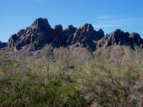
The photo above shows the North Gully Route marked in red. When you arrive at the base of the mountain and the North Gully, make sure you are on the left (east) side of the wash. The gully itself is steep, dirty, and loose. Just follow the gully straight up to the saddle. There may be vague trails at times, but just keep heading up and avoiding any plants with thorns.
You may be faced with the temptation to go left when an opportunity presents itself in the form of a passageway through the cliffs. Avoid this and keep heading up. The second temptation is when the gully forks and the right fork heads up and to the right side of a huge block. Avoid this temptation as well and continue straight up to the saddle.
Once the saddle is reached, the view is astounding! The Silver Bell Mountains stretch to the south, and the cliffs surrounding you on all sides make you feel as if you are on a much bigger mountain. The trail continues up and to the left. The steep incline leads to another gully. Scramble up this gully until you reach a notch and you can see to the north. Turn to your right and clamber up a single class 3 move onto the wall. Scramble the remaining 50 feet to the summit.
The summit views are rewarding! You can see the ASARCO copper mine to the southwest, the Silver Bell Mountains to the south, Baboquivari in the distance, and the Tucson Mountains to the southeast. Picacho Peak is to the north.
Return the way you came.