
|
|
Route |
|---|---|
|
|
38.14660°N / 119.5721°W |
|
|
Hike / scramble / technical route climb |
|
|
A few days |
|
|
5.2 ? |
|
|
Approach
The closest trailheads to the Saurian Crest are located at Leavitt Meadows from the north or at the Hetch Hetchy Reservoir from the south.1) From Leavitt Meadows Pack Station, follow the West Walker River trail south all the way to Tower Lake. Continue south over a low use trail over the saddle to Mary Lake. The Saurian Crest overlooks the western shoreline of Mary Lake.
2) From Hetch Hetchy Reservoir, take the trail north to Jack Main Canyon until you reach the PCT. Continue north until you reach the trail for Tilden Lake. Follow the trail on the western shore past the lake and continue northward until you reach Mary Lake. The Saurian Crest overlooks the western shoreline of Mary Lake. (23 miles total)
 |  |  |  |  |
Route Description
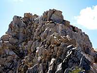
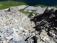
The ascent begins at the north end of Mary Lake. Start climbing the ridge due west. The lower part of the ridge is sandy but there are patches of granite and small boulders to aid your progress. As you gain elevation, the sand will yield to talus. The rocks are mostly stable, but as always, be careful for shifting rocks.Start traversing to the southwest towards the peak to avoid unnecessarily climbing the high ridgeline to the north. Aim for the orange rocks on the ridge near the saddle. Once you reach that point, the ridge will drop down to a snow covered saddle and then rise steeply up a talus field as shown here. The talus here is mostly stable but the ridge rises steeply enough to require some Class 3 climbing.
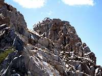
At the top of the rise, the ridge will become less steep but much narrower. This is where the fun begins. The ridge is quite narrow in places, full of jagged rocks and exposed on both sides. Carefuly make your way along the Class 3 ridgeline towards the summit, traversing on the left side when necessary.
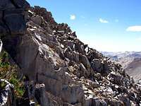
After some very enjoyable climbing along the ridge top, you will eventually reach the first and lower of the two main peaks. This is where I stopped and where the Class 5 climbing begins. The twin summit blocks both require what appears to be a few fairly easy low Class 5 moves. However, as I was climbing solo and unprotected, I didn't want to risk grabbing onto a loose rock as the route is exposed on both sides and a fall would be fatal here.
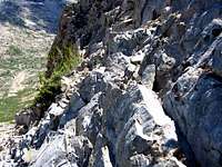
If you wish to only climb the true summit, the first summit block can be bypassed by traversing on the west (right side) as shown in this photo. This looks like an easy but very exposed Class 3 section. However, the south (and highest) summit block also looks like it requires a few low Class 5 moves to reach. Thus I decided to turn back at this point.
Start elevation: 9,650'
Summit: 11,095'
Elevation gain: 1,445'
Distance: ~ 1 mile
 |  |  |  |