|
|
Route |
|---|---|
|
|
37.88810°N / 108.2557°W |
|
|
Scramble |
|
|
Most of a day |
|
|
Class 2 |
|
|
Approach
From Norwood, drive 1.5 miles east. Turn south on County Road 44Z (Lone Cone Road). Turn east after 11 miles onto County Road 44M (Beef Trail Road) and follow it to County Road 46M and turn right (south) onto 46M. Road 46M becomes FS 611 once you reach the Forest Service boundary. 2.8 miles after the boundary, turn right onto FS 612. Turn right again after 1.7 miles and follow FS 612 for another 2.2 miles. Park at the vehicle barrier and the old logging road that takes off to the right. This place is at co-ordinates N37°54.390' W108°14.488'. Passenger cars, driven slowly and with lots of care could make it to the trailhead, but a high clearence vehicle is certainly recommended.Update from Jaypkk, August 2007: From the northeast along FS 612 as described was straightforward, GPS coordinates will get you to the right parking spot. Road would have been impossible in a low slung sedan; 4WD a must.
Route Description
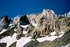
Note: I climbed this route in June, 2004 when much of the route was covered in snow. Because of this, the description may change some after the snow melts. This isn't a marked trail and there are several old logging roads in the area, so you must follow the topo map carefully.You will need a map to follow the route. From the trailhead at N37°54.390' W108°14.488', follow the old logging road up the ridge that is marked on the topo. There are a few side trails, but just stay close to the ridge until the old road ends at about 11,000 feet. Continue to follow the ridge on minor trails until you can see the huge rock glacier called the Devils Chair. Route find across the Devils Chair staying near the huge looming north face of Lone Cone, and while staying along the upper end of the rock glacier. The traverse will be easier before he snow melts off in early July or so. After crossing the Rock glacier, scramble up the very steep slop to the NW ridge of Lone Cone. This is the steepest part of the entire climb. One on the ridge, follow it to the summit. Boulder-hopping and minor scrambling is required before reaching the summit.