
|
|
Route |
|---|---|
|
|
40.81376°N / 107.37834°W |
|
|
Overview
This route is probably the easiest route to the summit of Mount Oliphant since it is the closest that any trail gets to the peak. The route follows the Willow Creek/Bears Ears Trail to the saddle between Mount Welba and Mount Oliphant before climbing the ridge south to the false summit. The crux of the route is a talus slope and then from the false summit there is much route finding through timber to reach the true summit.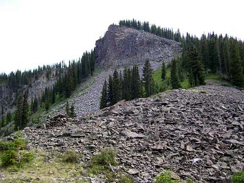 False Summit of Mount Oliphant as viewed from the Welba/Oliphant Saddle.
Getting There
Drive Highway 13 either north of Craig or south of Baggs to between Mile Markers 115 and 116 (this is about 25.5 miles north of Craig). Turn east on County Road 38 and follow it to Forest Road 109. The Forest Service boundary is about 9.7 miles from Highway 13 (after this point I took a wrong turn, so don’t have odometer readings).Stay on FR 109, ignoring all the named roads that branch from it. Before the Forest Service boundary, make sure to stay right at s junction (now marked). If you start heading away from the mountains, you are on the wrong road. After the Forest Service boundary, stay left at two junctions, while staying on FR 109. The second left is labeled “Willow Creek/Trail 1144”. Follow the road to a locked gate. The trail begins here on the east side of the road/parking lot.
Route Description
From the trailhead sign (marked for Willow Creek/Trail 1144), follow the trail east. (The trailhead is not marked on the map, but I believe it is near the "B" in "Bears Ears Trail" on the 7.5 minute quad). The trail is in very good condition by Elkhead Mountain standards and there were only a few logs to climb over in October 2005 and in August 2008. The stream crossings are even bridged.From the trailhead, the trail descends through the forest to Willow Creek, at which there is a bridge. Continue along the good trail through the forest. It will eventually switchback and climb east to the saddle between Mount Welba and Mount Oliphant. This is about 1.75 miles from the trailhead.
From the saddle, the trail descends east, but don’t take the trail. Instead, leave the trail and climb south up the ridge. Stay closed to and to the right of the cliffs while making your way up the steep talus slope. At the top of the false summit breathe easy as the route is easier from here on. Make sure to take lots of photos since the views are actually better from the false summit than the true summit.
To reach the true summit, head south keeping the steep slope to your left while route finding through the timber. If you head to far west you will reach another false summit. Persevere through the timber and look for the highest ground around. The summit area is more open than lower down. There is a register under the cairn at the summit.
I climbed the peak on August 17 2008 and there were only two other signatures in the log. The legendary Mike Garrat (Delores Colorado) placed the register on August 16 2003 and Ed Windal signed it on August 1 2007. I replaced the register jar with a larger and newer one.
Head back the same way. The round trip distance is about 5 miles with about 1900 feet elevation gain including the descent to Willow Creek and the ups and downs.
 The false summit of Mount Oliphant. The route goes just to the right of the cliff.
Essential Gear
A good pair of boots is needed. A trekking pole or poles is recommended to descend the talus slope.Make sure to have the Routt National Forest map to find the trailhead. The 7.5 minute quad map and a compass (or GPS) are useful for the hike itself.