
-
 8119 Hits
-
 73.06% Score
-
 3 Votes
|
|
Route |
|---|---|
|
|
40.79380°N / 110.6821°W |
|
|
Hike with routefinding and scrambling |
|
|
One to two days |
|
|
Class 3 |
|
|
Approach
This route to the summit of Mount Beulah begins at the East Fork Bear River trailhead. Refer to the main page 'Getting There' section for directions on accessing this trailhead. |  | 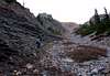 | 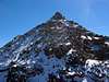 |
Stats
Round Trip Hiking Distance: 14.0 milesElevation Gain: 3,432 ft.
Trailhead Elevation: 9,125 ft.
Summit Elevation: 12,557 ft.
Route Description
This first part of this route follows the maintained trail leading to Allsop lake. This trail is well maintained and easy to follow. The route leaves the main trail approximately 2 miles prior to Allsop Lake, and proceeds by routefinding and scrambing to the north ridge and summit of Mount Beulah.From the trailhead the trail descends briefly for the first 0.5 miles, then begins a very gradual ascent as it follows the East Fork Bear River, staying on the right side of the river.
At 3.7 miles the trail splits, with the right fork continuing along the west fork of the river towards Priord and Norice Lakes. Take the left fork which continues south along the east fork of the river. The trail makes one brief switchback just after the the trail junction, then continues in a southward direction as it gradually gains elevation.
At approximately 5 miles (el. 9,800 feet) the trail begins to periodically break out of the forrested terrain, providing clear views of the steep and rugged west slopes of Mount Beulah. For those doing this hike as an overnight trip, this is a good place to begin looking for suitable campsites.
With the west side of Mount Beulah in view, leave the trail and begin routefinding east towards the slopes leading to the north ridge. A curving gully well to the north of the summit, as shown in this photo, provides a steep but suitable route to the north ridge. A second gully further to the south is an alternative path to the north ridge, but contains much loose rock and is not recommended.
Upon reaching the north ridge there will be a clear view of the summit. Begin following the ridge south. The large prominent pinnacle on the ridge is bypassed by scrambing around the base of the pinnacle on the west (right) side.
Past the pinnacle the ridge begins climbing more steeply. Stay generally on the ridge, but occasionally move to either side as required to ease the scrambing difficulty. There are many large and loose rocks on the ridge, so proceed with extreme caution.
The two large dropoffs on the ridge which were prominent from the Allsop Lake trail are bypassed with little difficulty by contouring on the east (left) side of the ridge.
The summit block is a large pinnacle which is most easily climbed by contouring around the right (west), then a quick scramble up the back (south) side.
Essential Gear
No special equipment is required for an ascent of Mount Beulah.Insect repellent is a must until late summer.
Water is abundant throughout the area - bring a suitable purification method.