
|
|
Route |
|---|---|
|
|
38.97940°N / 106.7998°W |
|
|
Most of a day |
|
|
Class 4 |
|
|
TOPO
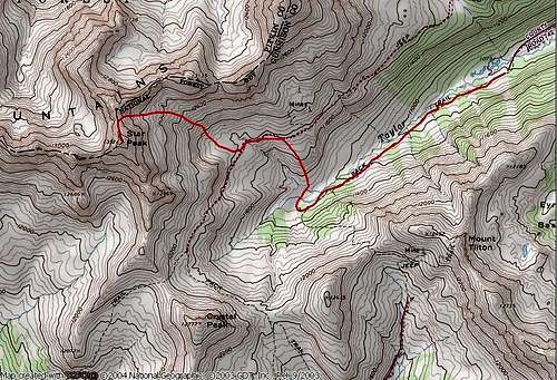
North Ridge on Star Peak
Getting There-Seemingly far away, the Taylor River area can easily be reached via a good road over Cottonwood Pass.
The Taylor River Trailhead (10,760-ft) can be approached from either Buena Vista or Crested Butte; I will describe the Buena Vista approach. From Buena Vista Colorado, drive west to Cottonwood Pass (12,126-ft.) on a paved road. Conditions permitting, the pass is usually open from mid to early May to mid to late October.
From Cottonwood Pass drive 13 miles on an improved dirt road to Taylor Reservoir. Measure from here: Turn right/north on the Taylor Park Road/742; it is an improved dirt road with plenty of “wash-board”. Pass the Spring Creek Reservoir/748 turn-off at mile 7. The Italian Creek Road at mile 9.6. The Taylor Pass Road at 15.5 and reach the very end of the road at 18.6 miles. There is a nice parking area here.
North Ridge
RT-6 miles & 2,600-ft
With a high trailhead start in the upper Taylor River area, Star Peak’s RT data is very reasonable. Climbing Star Peak from the Castle Creek/Pearl Basin area requires a lot more of effort. From the Montezuma Road/Pearl Pass intersection the route is 13 miles and 3,800-ft.
Begin your day at the Taylor River TH at 10,760-ft. You can see Star Peak’s summit from here up the valley and to the right. The talus ridden basin below the mountain is your first objective. From here, easily locate a good trail that runs parallel and south of Taylor Creek. Hike about 1.30 miles and locate a small drainage to the northwest. The shoulder on the right side of the drainage provides a good route up into the basin. This basin is leeward facing and might hold snow for much of the early summer months, however it does face south. With an early start, attacking this basin in June or July makes sense since snow cover would really expedite the approach.
Ascend the drainage about 500 vertical feet and reach an old mining road that traverses the lower basin. The road is not wide enough for a vehicle. Use this road or trail, and traverse maybe a quarter mile west. Leave the road and begin boulder hopping up the steepening slope. From here you can easily preview your route up the loose talus slope to a saddle between Star’s summit and point 13,362 (not listed on TOPO.) From here, put your helmet on. Continue up this moving slope (without snow) and take advantage of any lingering snow to help with the tedious ascent. Star Peak's summit is 1,500-ft above you. Generally, the footing is better on the right side of this slope, however be very aware of rock fall potential from the nasty ridge directly north.
After finally attaining the saddle, you are presented with the climbing crux of the climb. From the saddle, the north ridge makes a steep jump to the ridge crest. Take the ridge head on, and be aware of loose blocks. Remember, this route doesn’t get climbed often so anything loose has been loose for a long time. Much of it is ready to go. After maybe 20 feet of class 3+ climbing, the ridge becomes to narrow and steep. From here do a slight traverse to the left and down climb maybe 10 ft onto the exposed east face. Bypass the festooned ridge crest by ascending steep snow and rock and eventually make your way back up to the ridge crest (class 3.)
From here, the remaining climb to the summit is directly on the ridge crest and is only class 2+. There are no notches to deal with but there is considerable exposure on both sides of the north ridge. The summit view is spectacular. Descend you ascent route.