
-
 4405 Hits
-
 77.48% Score
-
 8 Votes
|
|
Route |
|---|---|
|
|
38.65530°N / 106.283°W |
|
|
Hiking, Scrambling |
|
|
Spring, Summer, Fall, Winter |
|
|
Most of a day |
|
|
Class 3 |
|
|
Overview
This route is the primary route on Cronin Peak when climbing from Baldwin Gulch. The route as described here is a variation of the route described in Gerry and Jennifer Roach's "Colorado Thirteeners". We started the route from much closer to the base of the ridge than their description. This route is mainly class 2, but there is one short section on the lower portion of the ridge that involves class 3 scrambling with exposure on not always stable rock. There is good rock to be had, but pick your holds with care. To avoid this section it is best to follow the Roach route. (Note, all images in this description were taken October 28, 2006)From 4WD parking area:
6 Miles RT
Appx 3050' elevation gain
Getting There
Turn west onto Chaffee Cty 162 from US 285 near Nathrop. Follow the initially paved road for about 12 miles to the signed Baldwin Gulch Jeep Road. From Cty 162 either walk or drive up the Baldwin Gulch Jeep Road to the Baldwin Lake/Mt Antero road split at a creek crossing at 10,840'. This point is roughly 3 miles and 1400' from Cty 162. Add this distance and vertical gain to the totals above if starting at the base of the road.Route Description
Cross the creek and follow the Mt Antero road to approximately 11,400'. At this point there is a knoll on the right that the main road goes around. Leave the road before this knoll, cross the creek, and head up the slopes through the trees to the base of the ridge at approximately 11,500'. Follow the initial ridge crest on talus, there is nearly 2 miles and 2300 vertical feet to go. As you climb the views around you will open up on this scenic ridge. Near 12,000' there is a section of exposed class 3 scrambling on sometimes loose rock. Carefully climb directly on the ridge crest through this section taking care to test your holds. Above this section, continue on the ridge crest over a series of small false to summits to a large false summit marked on the USGS topo map as PT 12591. The saddle on the south side of this ridge is the point where the Roach route joins the ridge. From this point the ridge's steepness relents some and progress is quick and straightforward. There are a couple of more small false summits before the final summit pitch is revealed. 250' of more talus climbing puts you on the summit, suspended in an ocean of Sawatch peaks. On a clear day you can see from Pikes Peak to Uncompahgre Peak. |  | 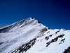 |  |
Essential Gear
In dry conditions nothing besides normal hiking gear is required. There are cornices that can develop on the ridge and when there is snow an ice axe may come in handy.Winter Considerations:
There is some definite avalanche prone terrain on the road leading into Baldwin Gulch, however, this ridge would make for a practical winter route when the conditions in the surrounding basin are safe. Ice axe and crampons recommended.
Route Map
See below for a map of this route: