
|
|
Route |
|---|---|
|
|
40.76810°N / 110.8332°W |
|
|
Hiking |
|
|
Spring, Summer, Fall, Winter |
|
|
Most of a day |
|
|
Class 2 |
|
|
 North ridge of A-1 Peak
Overview
A-1 peak (12377) is located at the northeast end of the Mirror Lake Highway in the Uinta Mountains of Utah about 35 miles south of Evanston Wyoming. In the summer when the highway is open, it is one of the easiest 12000 footers to climb in the Uintas. Most of the Uinta peaks are made difficult by the long approach hikes to their bases, but A-1 sits only 2.6 miles away from the highway as the crow flies.When the highway is closed, things are more difficult. This page describes a route up the north ridge of A-1 that is reasonable to do in the winter or spring when the highway is impassable.
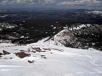
From the summit, many other 12000 footers are visible. The two most striking from this vantage point are Ostler Peak (12718) and East Hayden Peak (12284).
 Ostler Peak
 East Hayden Peak
Stats
Length (MLH gate open): 15 miles round tripLength (MLH gate closed): 23 miles round trip
Start elevation (MLH gate open): 8520 feet
Start elevation (MLH gate closed): 8360 feet
Summit elevation: 12377 feet
Getting There
 View east from route 150
 The north ridge of A-1 is clearly visible as you turn onto the Christmas Meadows road
When to Climb
 Hayden Fork
The best time for this route is winter or spring, but it can be done all year. In the summer or fall the Mirror Lake Highway will be open and a much shorter route exists that takes you over Kletting Peak too.
The ideal time to climb the north ridge of A-1 Peak is in the spring after the gate on the east end of the highway has been opened and you can drive all the way to the trailhead. If the gate is still closed it will add an additional 4 miles each way to the route. In 2009, the east end gate was opened on April 30. The date changes year to year depending upon snow conditions. Early in the year, even though the gate is open, the road is still officially closed and if you drive very far you will encounter snow and have to stop. However, if there is so little snow that the gate is open, you will probably be able to drive to the trailhead with no problem.
Those familiar with the area might be wondering if the MLH gate is open, why not drive on the road as far as you can go and then head for A-1, possibly over Kletting. I tried this and was able to drive as far as the Beaver View Campground. I walked about 3/4 mile farther on the road and then turned east to head for Kletting's north ridge. After encountering a few minor obstacles I hit a major one which was Hayden Fork. It is not crossable this time of year unless you are into swimming. I stuck my pole in to test its depth and it did not touch bottom.
Route Description
 The Hell Hole Basin road The Hell Hole Basin roadFrom the gate follow the dirt Hell Hole Basin road 4 miles until it ends. This road is gently graded and only climbs 1000 feet. Occasional glimpses of the peak will be visible through the trees but mostly it is just a nice walk through the woods with no views. |
 The first part of the ridge looks like this The first part of the ridge looks like thisWhen the road ends, continue east through the woods and shortly you will encounter a steep 200 foot climb to the top of the north ridge of A-1 which is reached in another .15 miles. Once the terrain levels off, turn south along the ridge. The first 2 miles of this ridge is gently sloped, forested, and is fairly wide. Mostly, it won't be obvious you are even on a ridge. You will gain another 1000 feet in this section. |
 The start of the narrow section The start of the narrow sectionFinally the ridge narrows and steepens and you go over a series of small bumps for the next half mile with views on either side. |
 Kletting Peak Kletting PeakTo the right is the north ridge of Kletting (12055). |
 Lamotte Peak Lamotte PeakTo the left is Lamotte (12720). |
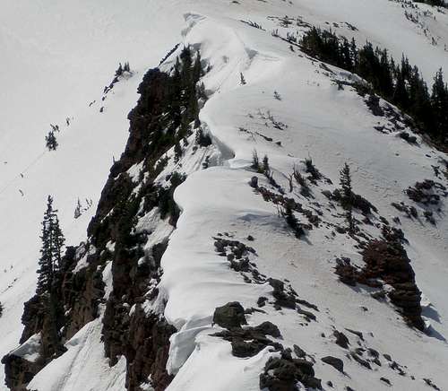 Cornices CornicesYou need to be careful not to step too close to the east side in this section since there are some large overhanging cornices there. |
 Approaching the summit Approaching the summitAfter the last small bump it is a steady 1500 foot climb in .9 miles to the summit. |
 Heading back down Heading back down |  Heading back down Heading back down |  Heading back down Heading back down |
Time needed
I did this route when the MLH gate was open so it was only 15 miles. It took 10 hours and 15 min round trip, but I got a late start and the snow was already soft. With an earlier start or a colder day it could be done much faster. If you start by 6am you should be able to make it to the top before things soften up.Essential Gear
If the snow is gone, nothing special is needed. If there is snow you will definitely need snowshoes and you might find crampons and an ice axe useful.Red Tape
There is a fee for parking at the trailhead as well as anyplace along the Mirror Lake Highway. You can buy an annual pass for $45, a 7 day pass for $12, or a 3 day pass for $6. You can also purchase an Interagency Annual Pass (America the Beautiful) for $80 which is good locally for the Mirror Lake Highway and American Fork Canyon, as well as all Forest Service, National Park Service, Bureau of Land Management, Bureau of Reclamation, and US Fish & Wildlife Service sites charging entrance or standard amenity fees. Considering that the annual pass for just the Mirror Lake Highway is $45, the $80 pass good everywhere is a real bargain. The $45 and $80 passes can be purchased at the Kamas Ranger Station at the beginning of the Mirror Lake Highway in Kamas. The $6 and $12 passes are available all along the highway in self pay tubes. The $80 America the Beautiful Pass can also be purchased at the customer service desk at the REI store in Salt Lake City located on 3300 East.Map
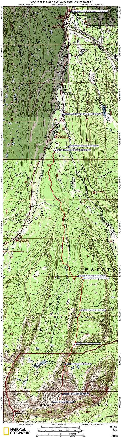 Topo map of route