-
 15627 Hits
-
 86.05% Score
-
 22 Votes
|
|
Route |
|---|---|
|
|
39.46650°N / 106.481°W |
|
|
Hiking |
|
|
Summer, Fall |
|
|
Most of a day |
|
|
Trail hike with some off trail talus |
|
|
Overview
A long trail hike through a rugged wilderness over a mountain pass and across a stream leads to a steep rugged trail through tundra and talus to the final off trail talus "boulder hopping".11.5 miles round trip
5600 vertical feet round trip (including reclimb of Halfmoon Pass)
Mostly Class 1 with Class 2 finish
Halfmoon Trailhead (see "getting there" on main page)
Approach
The route starts out from the parking area and follows the Halfmoon Trail, located at the end of the parking lot (not to be confused with the Fall Creek Trail which starts next to the campground). Fill out the free wilderness permit at a box near the trailhead. Follow this trail through the forest until it grazes treeline at 11,640' Halfmoon Pass, approximately 1 3/4 miles from the trailhead. Contour on the trail around the northwest slopes of Notch Mountain as you gain your first views of Holy Cross and Mt Jackson. You get a good view of the Angelica Couloir from here, but not the Cross.Descend steep switchbacks to 10,670' and East Cross Creek and cross it on a spindly log bridge that in early season can have water running over it. There are some camping sites here, but due to user impacts no campfires are allowed. All camping must be in designated sites only, refer to the main page for a map of sites. Breaking up the climb with a camp here can make your ascent easier, but as this area is overused it may be best to limit your impact and day climb instead. Take care to stay on the main trail through here, there are some side trails to the campsites and also to Lake Patricia that may be confusing.

Route Description
Once past the camping areas you will climb through a few short rock benches then enter the woods around 11,000' on a well defined but steep trail. Continue up the steep trail to treeline at around 11,600'. While earlier guide books will tell you the trail ends here, in recent years the CFI extended it. The trail remains well defined through the lower tundra covered ridge. Just below 12,000' you will get a view of the summit and the upper talus covered ridge.The trail stays in pretty good shape through here and is well cairned, just pay attention and you should be able to stay on route. The trail will eventually lead you to a long flat section of ridge near 13,500' and a good view of the remaining route. As you cross this flat area, stay on the trail or the rock. People often walk on the snow to the east (left), but this is not a good idea as that snow is the remnant of a cornice and if it were to collapse you would be sent tumbling down steep rocks.
At the end of this long section the trail starts to get less discernible as you begin the final steep talus ascent. At 13,700' you cross the top of Angelica Couloir and this is the effective end of any trail. Be careful not to knock any rocks down the couloir as there could be climbers below. The final 300' you are actually no longer traveling north-south, but almost due east. Scramble through the talus boulders to reach the summit.


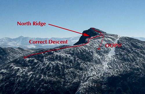
Descent
Holy Cross has a reputation for getting people lost, this is mainly due to the final 300-500' which curve to the east. On the descent many people do not realize they need to curve back to the north (the right on your descent) to get the main ridge and end up going straight down to Cross Creek. Many a rescue has been initiated by the local Search and Rescue team due to this common error. To ensure you don't need to be rescued, pay close attention on your ascent from the end of the flat ridge to the summit, turn around frequently to note landmarks for your return. You should be able to see the flat section of the north ridge within a few minutes of your descent, if not, keep traversing right until you do.Descend the trail back to the trailhead, reclimbing Halfmoon Pass en route (almost 1000' of vertical!).