
-
 7685 Hits
-
 86.37% Score
-
 22 Votes
|
|
Mountain/Rock |
|---|---|
|
|
37.94846°N / 122.28727°W |
|
|
Contra Costa |
|
|
Hiking |
|
|
Spring, Summer, Fall, Winter |
|
|
1057 ft / 322 m |
|
|
Overview

North from San Pablo Ridge
A good system of trails lead through some cattle country to the highpoint of 1,057'. The unobstructed 360 views of the northbay from this point are quite outstanding.
The hike to the peak can be done as part of a 6 mile loop or a hill climb over a few rollers from several trailheads.
Getting There
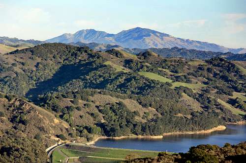
Over San Pablo Reservoir to Mt. Diablo from San Pablo Ridge peak
From Interstate 80 north get off on San Pablo Dam Road. Go right .3 miles to San Pablo Ave. Turn left and go .4 miles to Mc Bryde Ave. Turn left and go .5 miles (back under the freeway) to the stop sign across from with the Alvarado Park stone pillars. Continue on Park Ave. another 1/4 mile to the Wildcat Canyon Staging Area (el. 180'). This parking lot packs out on popular days but there is additional parking along the road to the right.
From Interstate 80 south get off on San Pablo Ave. and go north .7 miles to Mc Bryde Ave.. Turn right and go .5 miles to the stop sign across from Alvarado Park. Continue another 1/4 mile to the staging area parking lot.
The 6 mile loop takes the Wildcat Creek Trail 2 miles along the base of the ridge on an utterly boring deserted asphalt road bordering a neighborhood with no views. Then it climbs to the left up the Mezue Trail for 1.2 miles to the San Pablo Ridge Trail and turns left .3 miles to the 1,057' peak with fine views opening up along the way. There is a bench at the top facing west to relax and enjoy the views.
From there the San Pablo Ridge Trail continues northwest down from the highpoint and over some rollers approximately 1 mile where it connects with the Belgum Trail. The Belgum Trail goes west about .8 mile back down to the Wildcat Creek Trail. Turn right .4 miles back to the parking lot.
The direct route to the top takes the Wildcat Creek Trail .4 miles to the Belgum Trail. Go left up the Belgum Trail about .8 miles and continue to the southeast on the San Pablo Ridge over some steep little rollers to the 1,057' peak.
Other trailheads are:
Rifle Range Road Go .5 miles to the Wildcat Canyon Road then left .3 miles to the Mezue Trail.
Clark Road Go .7 miles up to the junction with the Belgum Trail.
The San Pablo Ridge peak is also accessible from the Conlon Trail and the Wildcat Creek Trail out of Tilden Natural Area to the southeast.
If you're lazy, have time constraints or want instant gratication you can drive along the top of the ridge on Nimitz Way to a highpoint of 1,040' and hike .8 miles along the top to the 1,057'.
Red Tape

Sunset over the Golden Gate from San Pablo Ridge

San Pablo Ridge from the northwest (from the Belgum Trail)
For details on rules and regulations go to Park Activities in Wildcat Regional Park
Camping

Sky over San Pablo Ridge
Current weather and 5 day forecast

Across the northbay to San Pablo Ridge from Marin County