
|
|
Route |
|---|---|
|
|
46.31092°N / 14.55886°E |
|
|
Hiking, Skiing |
|
|
Spring, Summer, Fall, Winter |
|
|
Most of a day |
|
|
Walk up (tour skiing) |
|
|
Overview
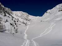 Winter idyll
Korošica is the first right bank affluent to the Kamniška Bistrica. It comes down from the east part the Krvavec group.
Upon reaching the upper end of the Korošica valley, one may head left (SW) to Krvavec and its ski resort, or right (NE) to summits such as Vrh Korena, Kompotela and Košutna that offer more of a tour-skiing idyll in winter, and quite easy hiking in the summer.
This page presents the standard ascent to Košutna, the last part being unmarked.
Uneasy orientation in the lower (marked) part.
Getting There
At km 5 of the road entering the Kamniška Bistrica valley (516 m, parking lot of the Velika Planina cableway, regular bus line from Kamnik), split W along a macadamized road, first descending, next crossing a bridge over the Bistrica stream. After the bridge, continue westward along the macadamized road entering the Korošica valley, ignoring the right-hand, the left-hand, and a further right-hand split in a left U turn. Park at Markova raven (979 m on maps), before the road crosses left to the opposite bank.Route Description
Follow the marked and secured path (red and white blazes) continuing up the valley.> Whenever splits come up, always choose the marked option to the right.
Pass a few clearings/pastures (Spodnja and Zgornja Frata, hutlet) and, heading now NE, reach the Planina Koren pasture (1675 m, hut leftover). Continue (the Jež ridge is to our left and the Košutna W slopes to our right) towards the end of the valley, finally ascending a chossy/pine-bushy slope to the col between Vrh Korena (left) and Kompotela. At the col, follow the inscription and blazes to the right (E), soon reaching the Kompotela summit. From Kompotela turn SW (back) towards Košutna (unmarked), searching for passages among pine bush (30 min + from the Kompotela summit).
Descend by the same route.
> In winter one needn't first reach the Kompotela summit: from the col one heads south, directly up the Košutna N slopes.
Essential Gear
Good hiking shoes, in Winter total equipment for tour skiing.Map
External Links
Grintovci 1:25000 mapKamnik-Savinja Alps hiking guide in Slovenian
Tips for Safe Trips to the Mountains